Archive for May, 2016
UNHCR, the UN refugee agency, says over 700 migrants are feared dead in 3 Mediterranean Sea shipwrecks south of Italy in the last few days .
Sunday, May 29th, 2016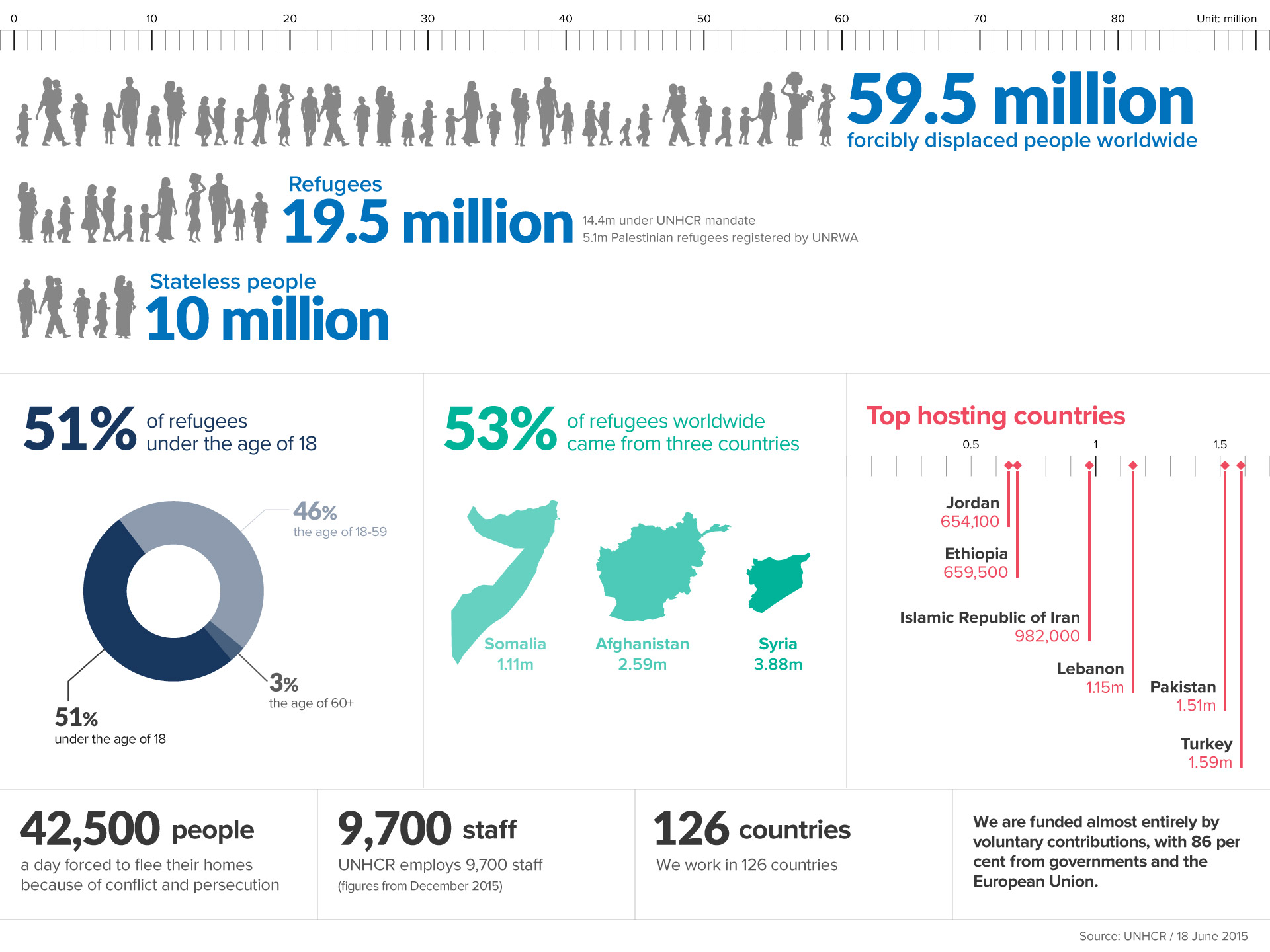
TS Bonnie
Sunday, May 29th, 2016![[Image of WPC QPF U.S. rainfall potential]](http://www.nhc.noaa.gov/storm_graphics/AT02/refresh/AL0216WPCQPF+gif/023507WPCQPF_sm.gif)
At 1100 PM EDT (0300 UTC), the center of Tropical Storm Bonnie was
located by an Air Force Reserve Hurricane Hunter aircraft near
latitude 31.0 North, longitude 79.5 West. Bonnie is currently
stationary. A motion toward the north-northwest is expected to begin
overnight, followed by a turn toward the north as the center of
Bonnie moves near the coast in the warning area on Sunday. A slow
northeastward motion near the central and northern coast of South
Carolina is expected Sunday night and Monday.
Data from the aircraft indicate that maximum sustained winds have
increased to near 45 mph (75 km/h) with higher gusts. Little change
in strength is expected overnight. Some weakening is expected to
begin by late Sunday.
Tropical-storm-force winds extend outward up to 70 miles (110 km),
mainly to the northwest of the center.
The latest estimated minimum central pressure based on data from
the aircraft is 1008 mb (29.77 inches).

HAZARDS AFFECTING LAND
———————-
RAINFALL: Bonnie is expected to produce total rainfall accumulations
of 2 to 4 inches with maximum amounts around 6 inches from central
and eastern South Carolina to the Georgia border. Rainfall
accumulations of 1 to 3 inches are expected across southeastern
North Carolina.
WIND: Tropical storm conditions are expected to first reach the
coast within the warning area overnight or early Sunday.
STORM SURGE: Storm surge inundation of 1 to 2 feet above ground
level is possible within the tropical storm warning area during the
next high tide on Sunday morning.
SURF: Bonnie is expected to produce life-threatening surf and rip
current conditions along portions of the southeastern United States
coast through the weekend. Please consult products from your local
weather office.
TORNADOES: An isolated tornado will be possible late tonight and
early Sunday over the immediate South Carolina coastal region.
NEXT ADVISORY
————-
Next intermediate advisory at 200 AM EDT.
Next complete advisory at 500 AM EDT.
$$
Forecaster Brennan
![[Image of 5-day forecast and coastal areas under a warning or a watch]](http://www.nhc.noaa.gov/storm_graphics/AT02/refresh/AL0216W5_NL+gif/023507W5_NL_sm.gif)
NOAA: The 2016 Atlantic hurricane season (June 1 — November 30) will most likely be near-normal, but forecast uncertainty in the climate signals that influence the formation of Atlantic storms make predicting this season particularly difficult.
Saturday, May 28th, 2016Near-normal Atlantic hurricane season is most likely this year
")
NOAA predicts a 70 percent likelihood of 10 to 16 named storms (winds of 39 mph or higher), of which 4 to 8 could become hurricanes (winds of 74 mph or higher), including 1 to 4 major hurricanes (Category 3, 4 or 5; winds of 111 mph or higher). While a near-normal season is most likely with a 45 percent chance, there is also a 30 percent chance of an above-normal season and a 25 percent chance of a below-normal season. Included in today’s outlook is Hurricane Alex, a pre-season storm that formed over the far eastern Atlantic in January.
“This is a more challenging hurricane season outlook than most because it’s difficult to determine whether there will be reinforcing or competing climate influences on tropical storm development,” said Gerry Bell, Ph.D., lead seasonal hurricane forecaster with NOAA’s Climate Prediction Center. “However, a near-normal prediction for this season suggests we could see more hurricane activity than we’ve seen in the last three years, which were below normal.”
Bell explained there is uncertainty about whether the high activity era of Atlantic hurricanes, which began in 1995, has ended. This high-activity era has been associated with an ocean temperature pattern called the warm phase of the Atlantic Multi-Decadal Oscillation or AMO, marked by warmer Atlantic Ocean temperatures and a stronger West African monsoon. However, during the last three years weaker hurricane seasons have been accompanied by a shift toward the cool AMO phase, marked by cooler Atlantic Ocean temperatures and a weaker West African monsoon. If this shift proves to be more than short-lived, it could usher in a low-activity era for Atlantic hurricanes, and this period may already have begun. High- and low-activity eras typically last 25 to 40 years.
In addition, El Niño is dissipating and NOAA’s Climate Prediction Center is forecasting a 70 percent chance that La Niña — which favors more hurricane activity — will be present during the peak months of hurricane season, August through October. However, current model predictions show uncertainty as to how strong La Niña and its impacts will be.
")
Despite the challenging seasonal prediction, NOAA is poised to deliver actionable environmental intelligence during the hurricane season with more accuracy to help save lives and livelihoods and enhance the national economy as we continue building a Weather-Ready Nation.
“This is a banner year for NOAA and the National Weather Service — As our Hurricane Forecast Improvement Programoffsite link turns five, we’re on target with our five-year goal to improve track and intensity forecasts by 20 percent each,” said NOAA Administrator Kathryn Sullivan, Ph.D. “Building on a successful supercomputer upgrade in January, we’re adding unprecedented new capabilities to our hurricane forecast models — investing in science and technology infusion to bring more accuracy to hurricane forecasts in 2016.”
Coming online later this season are major new investments to further improve NOAA’s ability to monitor hurricanes as they form and provide more timely and accurate warnings for their impacts. NOAA’s new National Water Model — set to launch later this summer — will provide hourly water forecasts for 700 times more locations than our current flood forecast system, greatly enhancing our ability to forecast inland flooding from tropical systems. In the fall, NOAA will launch GOES-R, a next generation weather satellite that will scan the Earth five times faster, with a resolution four times greater than ever before, to produce much sharper images of hurricanes and other severe weather.
NOAA works with a number of partners in the private and public sectors to ensure communities and businesses have the information they need to act well ahead of a land-falling hurricane.
“While seasonal forecasts may vary from year to year — some high, some low — it only takes one storm to significantly disrupt your life,” stated FEMA Deputy Administrator Joseph Nimmich. “Preparing for the worst can keep you, your family, and first responders out of harm’s way. Take steps today to be prepared: develop a family communications plan, build an emergency supply kit for your home, and make sure you and your family know your evacuation route. These small steps can help save your life when disaster strikes.”
NOAA will issue an updated outlook for the Atlantic hurricane season in early August, just prior to the peak of the season.
")
NOAA also issued its outlook for the eastern Pacific and central Pacific basins. The central Pacific hurricane outlook calls for equal 40 percent chance of a near-normal or above-normal season with 4-7 tropical cyclones likely. The eastern Pacific hurricane outlook calls for a 40 percent chance of a near-normal hurricane season, a 30 percent chance of an above-normal season and a 30 percent chance of a below-normal season. That outlook calls for a 70 percent probability of 13-20 named storms, of which 6-11 are expected to become hurricanes, including 3-6 major hurricanes.
NOAA’s mission is to understand and predict changes in the Earth’s environment, from the depths of the ocean to the surface of the sun, and to conserve and manage our coastal and marine resources. Join us on Twitter, Facebook, Instagram and our other social media channels.
The National Institute of Allergy and Infectious Diseases (NIAID) of NIH has exercised an option to fund animal efficacy and toxicology studies for Soligenix’s RiVax ricin vaccine as a bioterror preparedness measure
Saturday, May 28th, 2016
Local transmission of Zika virus infection has been reported in Tucumán Province, Argentina.
Friday, May 27th, 2016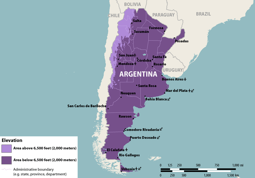
Zika Virus in Pregnancy
A pregnant woman can pass Zika virus to her fetus. Infection during pregnancy can cause serious birth defects. CDC recommends special precautions for the following groups:
- Women who are pregnant:
- Should not travel to any area of Argentina below 6,500 feet (see map).
- If you must travel to one of these areas, talk to your doctor first and strictly follow steps to prevent mosquito bites during your trip. If your itinerary is limited entirely to areas above 6,500 feet, there is minimal risk of getting Zika from a mosquito.
- If you have a male partner who lives in or has traveled to Argentina, either use condoms or do not have sex (vaginal, anal, or oral) during your pregnancy.
- Women who are trying to become pregnant:
- Before you or your male partner travel, talk to your doctor about your plans to become pregnant and the risk of Zika virus infection.
- See CDC guidance for how long you should wait to get pregnant after travel to Argentina.
- You and your male partner should strictly followsteps to prevent mosquito bites.
- Men who have traveled to an area with Zika and have a pregnant partner should use condoms or not have sex (vaginal, anal, or oral) during the pregnancy.
CDC researchers estimate that the risk of microcephaly is 1% to 13% in those sickened with Zika during their first trimester.
Friday, May 27th, 2016Indonesia: Child sex abuse is now punishable by death and chemical castration
Thursday, May 26th, 2016The new law was issued by the president following the brutal gang rape and murder of a 14-year-old girl.
PAHO reported 27,505 new suspected and confirmed chikungunya cases—almost all in Brazil—bringing the 2016 total to 114,199 cases.
Thursday, May 26th, 2016
Idomeni refugee camp: The evacuation will last several days and will move refugees and migrants to camps farther south that are designed to hold thousands of people.
Wednesday, May 25th, 2016“….Idomeni is an informal camp, with individuals pitching tents and some humanitarian groups providing assistance…..
Conditions in the crowded camp were often grim, with frigid nights in the winter, flimsy tents doused by rain, and the ground churned up into mud….”