Kilauea: Hundreds of homes in the Kapoho Beach Lots and Vacationland communities have been destroyed.
June 7th, 2018HAWAIIAN VOLCANO OBSERVATORY STATUS REPORT
U.S. Geological Survey
Wednesday, June 6, 2018, 2:34 PM HST (Thursday, June 7, 2018, 00:34 UTC)
KILAUEA VOLCANO (VNUM #332010)
19°25’16” N 155°17’13” W, Summit Elevation 4091 ft (1247 m)
Current Volcano Alert Level: WARNING
Current Aviation Color Code: RED
Kīlauea Volcano Lower East Rift Zone
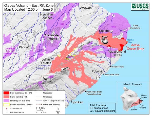
Vigorous eruption of lava continues from the lower East Rift Zone (LERZ) fissure system in the area of Leilani Estates.
This morning, lava fountaining at Fissure 8 continued to reach heights of 150-180 feet, feeding a stable channel to the east to the ocean entry in the Kapoho Bay area. Lava is entering the ocean in the Vacationland subdivision. Vacationland has been completely covered by lava, and overnight the flow expanded north by 100 m within Kapoho Beach Lots. The lava delta that formed at Kapoho Bay extended slightly overnight.
The northern lobe of the Fissure 8 flow shows no signs of activity this morning, and there is only wispy smoke at the flow front. No other fissures are active.
Pele’s hair and other lightweight volcanic glass from high fountaining of Fissure 8 are falling downwind of the fissure and accumulating on the ground within Leilani Estates. Winds may waft lighter particles to greater distances. Residents are urged to minimize exposure to these volcanic particles, which can cause skin and eye irritation similar to volcanic ash.
The most recent map of lava flows can be found at https://volcanoes.usgs.gov/volcanoes/kilauea/multimedia_maps.html
HVO field crews are on site tracking the fountains, lava flows, and spattering from multiple fissures as conditions allow and are reporting information to Hawaii County Civil Defense.
Volcanic gas emissions remain very high from the fissure eruptions. For the next few days wind conditions may bring vog not only to the south and west sides of the Island of Hawaii, but also the island’s interior.
The ocean entry is a hazardous area. Hazards include walking on uneven, glassy lava flow surfaces and around unstable, vertical sea cliffs. Venturing too close to an ocean entry on land or the ocean exposes you to flying debris from sudden explosive interaction between lava and water. Also, the lava delta is unstable because it is built on unconsolidated lava fragments and sand. This loose material can easily be eroded away by surf, causing the new land to become unsupported and slide into the sea. In several instances, such collapses have also incorporated parts of the older sea cliff. Additionally, the interaction of lava with the ocean creates “laze”, a corrosive seawater plume laden with hydrochloric acid and fine volcanic particles that can irritate the skin, eyes, and lungs.
Magma continues to be supplied to the lower East Rift Zone. Earthquake locations have not moved farther downrift in the past few days and the number of located earthquakes remains low. Seismicity remains relatively low with numerous small magnitude earthquakes and low amplitude background tremor.
Additional ground cracking and outbreaks of lava in the area of the active fissures are possible. Residents downslope of the region of fissures should heed all Hawaii County Civil Defense messages and warnings.
USGS/HVO continues to monitor the lower East Rift Zone activity 24/7 in coordination with Hawaii County Civil Defense.
Kīlauea Volcano Summit
Earthquake activity is increasing after Tuesday morning’s small explosion, with ten M3+ earthquakes since 5 am in the Kīlauea summit area. This pattern suggests that more felt earthquakes and a small explosion are likely within the next few hours. Monitoring data indicate that subsidence at the summit and inward slumping of the rim and walls of Halema`uma`u continues.
Over the last week, sulfur dioxide emissions from the volcano’s summit have decreased, but emission rates remain high enough to impact air quality in downwind regions. Additional bursts of gas released with intermittent explosive activity are also transported downwind and may temporarily affect air quality as well.
For forecasts of where ash would fall under forecast wind conditions, please consult the Ash3D model output here: https://volcanoes.usgs.gov/observatories/hvo/activity_2018.html
Information on volcanic ash hazards and how to prepare for ash fall maybe found at http://www.ivhhn.org/information#ash (health impacts) OR https://volcanoes.usgs.gov/volcanic_ash/ (other impacts).
MORE INFORMATION
Activity Summary also available by phone: (808) 967-8862
Subscribe to these messages: https://volcanoes.usgs.gov/vns2/
Webcam images: https://volcanoes.usgs.gov/volcanoes/kilauea/multimedia_webcams.html
Photos/Video: https://volcanoes.usgs.gov/volcanoes/kilauea/multimedia_chronology.html
Lava Flow Maps: https://volcanoes.usgs.gov/volcanoes/kilauea/multimedia_maps.html
Definitions of terms used in update: https://volcanoes.usgs.gov/volcanoes/kilauea/extra/definitions.pdf
Overview of Kīlauea summit (Halemaʻumaʻu) and East Rift Zone (Puʻu ʻŌʻō ) eruptions:
https://volcanoes.usgs.gov/volcanoes/kilauea/extra/background.pdf
Summary of volcanic hazards from Kīlauea eruptions:
https://volcanoes.usgs.gov/volcanoes/kilauea/extra/hazards.pdf
Recent Earthquakes in Hawai’i (map and list):
https://volcanoes.usgs.gov/hvo/earthquakes/
Explanation of Volcano Alert Levels and Aviation Color Codes:
https://volcanoes.usgs.gov/activity/alertsystem/index.php
https://pubs.usgs.gov/fs/2006/3139/
CONTACT INFORMATION:
askHVO@usgs.gov
The Hawaiian Volcano Observatory is one of five volcano observatories within the U.S. Geological Survey and is responsible for monitoring volcanoes and earthquakes in Hawai`i.