Archive for the ‘Earthquake’ Category
Eight people were killed after back-to-back earthquakes (5.9M/4.5M) struck the northern Philippines Saturday
Saturday, July 27th, 2019
|
 |


A 5.3M earthquake hit Friday near Athens, Greece
Friday, July 19th, 2019
|
 |


“The two powerful earthquakes that rocked the Mojave Desert this month were part of a swarm of thousands of other earthquakes, many too weak to be felt, that continue to hit the area every few minutes…..”
Friday, July 19th, 2019“….The 6.4-magnitude earthquake on July 4 was a precursor, or foreshock, to the much larger 7.1-magnitude quake the next evening, which released about 11 times more energy than the first…..”
7/16/1990: More than 1,000 people are killed when a 7.7-magnitude earthquake strikes Luzon Island in the Philippines.
Tuesday, July 16th, 2019NASA: How California Earthquakes Moved The Earth
Saturday, July 13th, 2019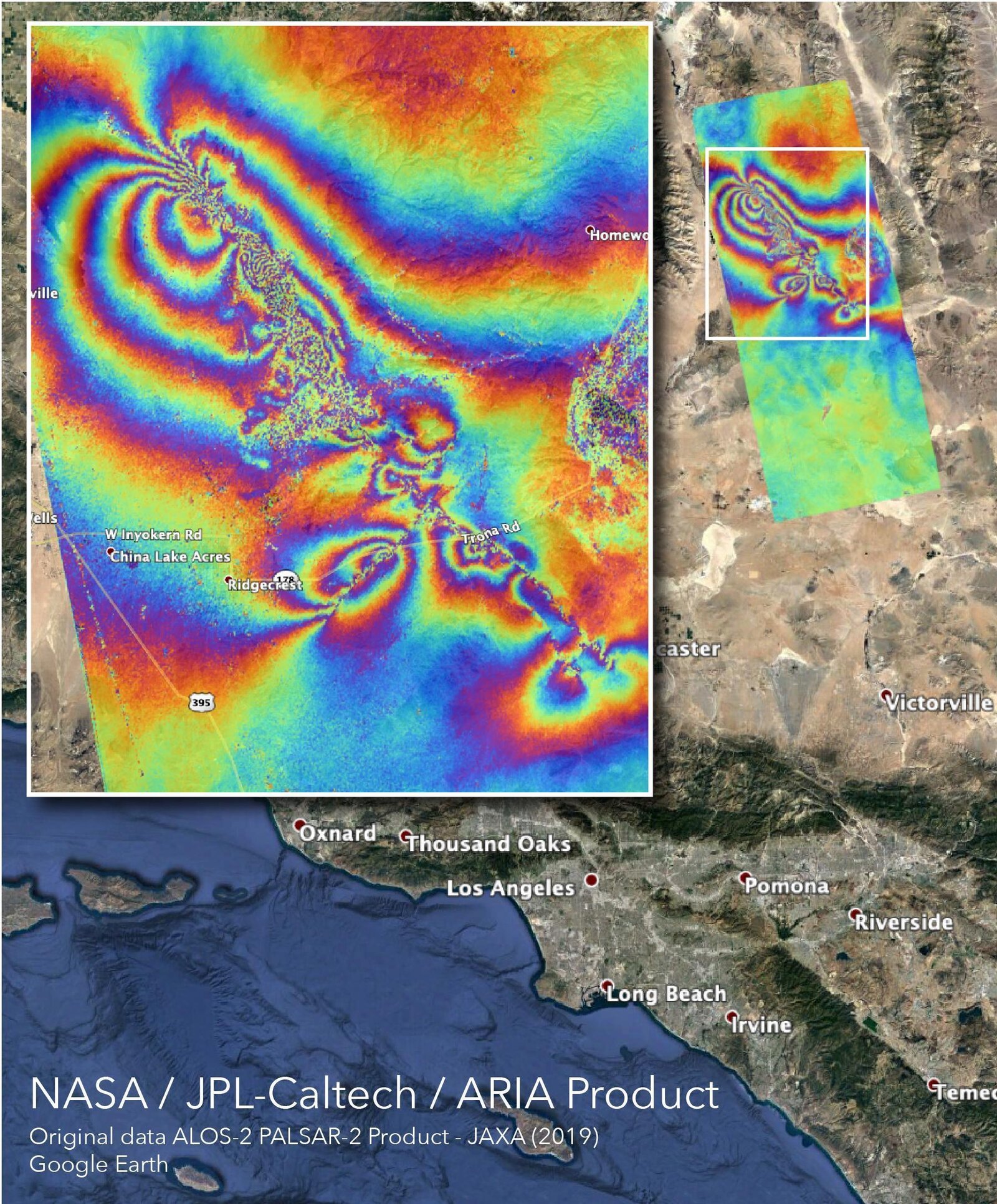
“……The map was created by the Advanced Rapid Imaging and Analysis team at NASA’s Jet Propulsion Laboratory. It shows rippling rainbows forming a circular pattern around the faults of the two quakes.
Each rainbow stripes means that the ground has been displaced there by some 4.8 inches…..”
California: When will The Big One come?
Sunday, July 7th, 2019
Tectonic Summary
The July 6th, 2019, 03:19 UTC (July 5th 20:19 locally) Mw 7.1 earthquake in eastern California, southwest of Searles Valley, occurred as the result of shallow strike slip faulting in the crust of the North America plate. Focal mechanism solutions for the earthquake indicate rupture occurred on a steeply dipping fault as the result of either right lateral slip on a plane striking NW-SE, or as left lateral slip on a plane striking SW-NE. At the location of this earthquake, approximately 150 km northeast of San Andreas Fault – the major plate boundary in the region – the Pacific plate moves to the northwest with respect to the North America plate at a rate of approximately 48 mm/yr. The location of the earthquake falls within the Eastern California shear zone, a region of distributed faulting associated with motion across the Pacific:North America plate boundary, and an area of high seismic hazard. More detailed studies will be required to precisely identify the causative fault associated with this event, though seismic activity over the past 2 days has been occurring on two conjugate fault structures in the Airport Lake Fault Zone.
This earthquake occurs approximately 34 hours after and 11 km northwest of a M 6.4 event in the same region, on July 4th, 2019, at 17:33 UTC. The July 4th event was preceded by a short series of small foreshocks (including a M4.0 earthquake 30 minutes prior), and was followed by a robust sequence of aftershocks, including almost 250 M 2.5+ earthquakes (up until the M 7.1 event). Those events aligned with both nodal planes (NE-SW and NW-SE) of the focal mechanism solution of the M 6.4 event, which was very similar in faulting style to today’s M 7.1 earthquake. The sequence includes two other M5+ earthquakes, one of which occurred 20 seconds before the M 7.1 event. The M 7.1 earthquake occurred at the NW extension of the prior sequence.
While commonly plotted as points on maps, earthquakes of this size are more appropriately described as slip over a larger fault area. Strike-slip-faulting events of the size of the July 6, 2019, earthquake are typically about 70×15 km (length x width).
This region of eastern California has hosted numerous moderate sized earthquakes. Over the past 40 years, prior to the July 4th event, 8 other M5+ earthquakes have occurred within 50 km of the July 6th, 2019 earthquake. The largest of these was a M 5.8 event on September 20, 1995, just 3 km to the west of today’s event, which was felt strongly in the China Lake-Ridgecrest area, and more broadly from Los Angeles to Las Vegas.
6/21/1990: A 7.7M earthquake near the Caspian Sea in Iran kills an estimated 50,000 and injures another 135,000 people
Friday, June 21st, 20196/17/2019: M 5.8 – 19km S of Changning, China: Left 12 people dead and 135 others injured.
Tuesday, June 18th, 2019
The June 17, 2019, M 5.8 earthquake in the Chinese province of Sichuan occurred as the result of oblique reverse and strike-slip faulting at shallow depths in the crust of the Eurasia plate. Focal mechanism solutions for the event indicate rupture occurred on either a steeply dipping fault striking towards the south, or on a more moderately dipping fault striking towards the northwest. The location, depth and preliminary focal mechanism solution for this earthquake indicate the event occurred as the result of intraplate faulting within the Eurasia plate.
On a continental scale, the seismicity of central and eastern Asia is a result of northward convergence of the India plate against the Eurasia plate at a velocity of about 50 mm/yr. The convergence of the two plates is broadly accommodated by the uplift of the Asian highlands and by the motion of crustal material to the east away from the uplifted Tibetan Plateau. The June 17 event occurred near the edge of a major uplifted plateau to the south and the Sichuan Basin to the north and may relate to the active tectonics of this juxtaposition.
Seismicity in the region is relatively common, with five earthquakes above M 6.0 within 250 km distance since 1900. The most recent such event was the August 3, 2014 M 6.2 event near Wenping China, about 200 to the southwest. Slightly further away, the very large May 12, 2008, M 7.9 Wenchuan earthquake occurred about 330 km northwest of June 17 event. That event killed more than 69,000 people, with an estimated economic loss of 86 Billion US dollars.