Archive for the ‘Volcano’ Category
Guatemala’s Fuego volcano exploded again on Tuesday, sending rescue workers scrambling for cover beneath the smoking peak, as the death toll from the weekend’s eruption rose to at least 72.
Wednesday, June 6th, 2018At least six people are dead and 20 were injured after Volcan de Fuego erupts
Monday, June 4th, 2018Volcán de Fuego y sus erupciones… pic.twitter.com/6T9TxQ6hOo
— Guía espiritual. (@renato_lechuga) June 3, 2018
USGA on Kilauea: The current lava flows east of Pahoa have forced the evacuation of thousands of residents and destroyed close to 100 structures, including at least 41 homes.
Friday, June 1st, 2018NASA: Kilauea’s lava flow from space
Thursday, May 31st, 2018
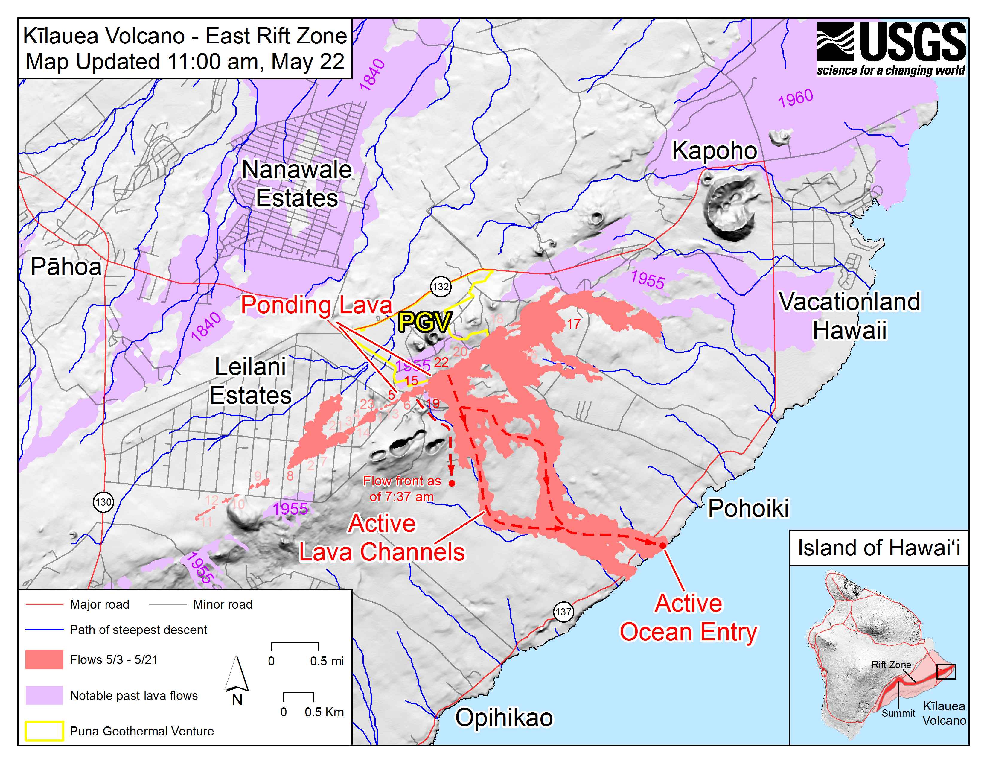
Though Kilauea has been erupting continuously from the Pu’u O’o vent since 1983, the eruption took a dangerous turn on May 3, 2018, when new fissures opened in the residential neighborhood of Leilani Estates. Three weeks later, some fissures have become less active but several others have emerged along the Lower East Rift Zone, including a few just northeast of Leilani Estates.
As of May 25, 2018, geologists with the U.S. Geological Survey were tracking 23 fissures. One of the most active is fissure 22, which has shed enough lava to create a channel that extends all the way to Hawaii’s southeastern coast. That lava is entering the ocean near MacKenzie State Park. Though it is routine for lava from Kilauea to reach the ocean, this is a new entry point.
The Operational Land Imager (OLI) on Landsat 8 acquired the data for this false-color view of the lava flow as it appeared on the night of May 23, 2018. The image is based on OLI’s observations of shortwave infrared and green light (bands 6-5-3). It was cloudy when the data was acquired, but a small break in the clouds made it possible to image the lava flows. The purple areas surrounding the flows are clouds lit from below. The animation also makes use of a daytime-image from OLI, with information about the location of roads and coastlines.
Geologists with the Hawaiian Volcano Observatory are monitoring the fissure eruptions closely. While seismometers and other ground-based instruments can track the underground movement of magma to some degree, it is not possible to predict with a high degree of accuracy how long a particular fissure will remain active or how much lava it will produce.
In the coming weeks, magma may continue to emerge from new fissures or slip back and forth between existing fissures. “Or the eruption could concentrate on some central vent,” explained Patrick Whelley, a planetary geologist working at NASA Goddard Space Flight Center. “It’s uncertain if this is a new phase for Kilauea or if this is just a short-lived escalation, and the activity will go back to Pu’u O’o in a month or so.”
The U.S. Geological Survey and Hawaii County Civil Defense are the best sources of information about the most recent activity at Kilauea.
-
References and Further Reading
- Global Volcanism Program (2018) Kilauea. Accessed May 24, 2018.
- In the Company of Volcanoes (2018, February 21) Communicating volcanoes: resources for media. Accessed May 24, 2018.
- Hawaii County Civil Defense (2018) Kilauea Eruption Information Resources. Accessed May 24, 2018.
- NASA Earth Science Disasters Program (2018) Kilauea, Hawaii Eruption 2018. Accessed May 24, 2018.
- United States Geological Survey Kilauea. Accessed May 24, 2018.
NASA Earth Observatory image by Joshua Stevens, using Landsat data from the U.S. Geological Survey. Story by Adam Voiland.
- Instrument(s):
- Landsat 8 – OLI
FEMA: Latest update on Kilauea
Tuesday, May 22nd, 2018Situation Moderate-level eruption of lava continues from multiple points along the northeast end of the active fissure system and additional outbreaks of lava are possible.
Ground deformation has slowed and seismicity levels have decreased.
Lava is entering the ocean just north of MacKenzie State Park and producing laze (an acidic plume of hydrochloric acid gas, steam, and tiny volcanic glass particles).
USCG has issued a Notice to Mariners establishing a safety zone 300 meters in all directions around all entry points of lava into the ocean – all vessels are to remain clear of this zone.
USGS Volcano Alert Level: WARNING; Aviation Color Code: RED
Impacts
• Injuries / Fatalities: 4 injuries / 0 fatalities
• Evacuations: Mandatory for 2k residents; a community of 40 homes isolated by lava flow was evacuated over the weekend
• Shelters: 5 / 139 (+21) (ARC Midnight Shelter Count, 7:17 a.m. EDT)
• Damage: 40 structures (27 homes)
• Transportation: FAA Temporary Flight Restriction in effect through May 26
State / Local Response
• HI EOC at Partial Activation (days only)
• Governor declared a State of Emergency and activated HI National Guard FEMA Response
• Region IX: LNO demobilized from HI EOC; RWC and Pacific Area Watch at Steady State
• National IMAT East-1 (with elements of National East-2), and Bothell MERS deployed to HI
• NWC continues to monitor
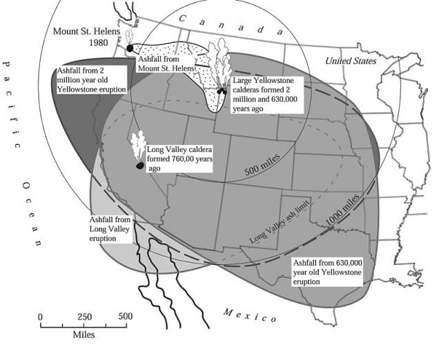
May 18, 1980: Mt. St. Helens erupts; 60 killed
Friday, May 18th, 2018Prior to 1980, Mount St. Helens had the shape of a conical, youthful volcano sometimes referred to as the Mount Fuji of America. During the 1980 eruption the upper 400 m (1,300 ft) of the summit was removed by a huge debris avalanche, leaving a 2 x 3.5 km (1.2 x 2.2 mi) horseshoe-shaped crater now partially filled by a lava dome and a glacier. It is primarily an explosive dacite volcano with a complex magmatic system.
Mount St. Helens was formed during four eruptive stages beginning about 275,000 years ago and has been the most active volcano in the Cascade Range during the Holocene. Prior to about 12,800 years ago, tephra, lava domes, and pyroclastic flows were erupted, forming the older St. Helens edifice, but a few lava flows extended beyond the base of the volcano. The bulk of the modern edifice (above the 1980 crater floor) was constructed during the last 3,000 years, when the volcano erupted a wide variety of products from summit and flank vents. Historical eruptions in the 19th century originated from the Goat Rocks area on the north flank, and were witnessed by early settlers. New unpublished data on the timing for Mount St. Helens eruptive activity have been analyzed, which improves some of the eruption dates cited in published literature. This website contains the most up to date information.
Since its 1980 eruption, the summit elevation has decreased. A survey in 1982 gave a measurement of 2549.7 m (8365 ft). However, a lidar survey done in 2009 found the maximum elevation to be 2539 m (8330 ft). The difference in elevation is likely due to erosion and loss of rimrock by crater-wall collapses.

USGS on Kilauea: Sunday, May 13, 2018, 8:28 PM HST (Monday, May 14, 2018, 06:28 UTC)
Monday, May 14th, 2018HAWAIIAN VOLCANO OBSERVATORY STATUS REPORT
U.S. Geological Survey
Sunday, May 13, 2018, 8:28 PM HST (Monday, May 14, 2018, 06:28 UTC)
KILAUEA VOLCANO (VNUM #332010)
19°25’16” N 155°17’13” W, Summit Elevation 4091 ft (1247 m)
Current Volcano Alert Level: WARNING
Current Aviation Color Code: ORANGE
Lower East Rift Zone Eruption
Eruption of lava continues from the northeast end of the active fissure system. Residents in lower Puna should remain informed and heed Hawaii County Civil Defense closures, warnings, and messages (http://www.hawaiicounty.gov/active-alerts).
As of late today, activity was dominated by lava fountaining, explosion of spatter bombs hundreds of feet into the air, and several advancing lava flow lobes moving generally northeast from fissure 17 at the downrift (northeast) end of the new fissure system. As of about 7 pm, one lobe was 2 yards thick and advancing roughly parallel to Highway 132. The flow front was just over a half mile southeast of the intersection of Highway 132 and Noni Farms Road.
Based on overflight images late this afternoon, additional lava from fissure 17 was also moving slowly southeast. Volcanic gas emissions remain elevated.
For the most recent map showing the locations of activity, please see https://volcanoes.usgs.gov/volcanoes/kilauea/multimedia_maps.html
HVO field crews are on site overnight tracking the lava flow as conditions allow and reporting information to Hawaii County Civil Defense.
This eruption is still evolving and additional outbreaks of lava are possible. The location of future outbreaks could include areas both uprift (southwest) and downrift (northeast) of the existing fissures, or, existing fissures can be reactivated. Communities downslope of these fissures could be at risk from lava inundation. Activity can change rapidly.
For information on volcanic air pollution, please see: http://www.ivhhn.org/vog/
Kīlauea Volcano Summit
Deflationary tilt continues. A robust plume of steam and volcanic gas, occasionally mixed with ash, has risen from the Overlook crater within Halemaumau. Over the course of the day, rockfalls from the steep walls enclosing the Overlook crater generated ash clouds mixed with steam and gas intermittently throughout the day. These ash clouds have been relatively low concentration and have risen at most only a few thousand feet above the ground, a few generating very localized ashfall downwind. More explosive activity generating larger ash clouds remains possible and can occur with no warning.
Earthquake activity in the summit remains elevated with several strongly felt events at HVO today. Most of these earthquakes are related to the ongoing subsidence of the summit area and earthquakes beneath the south flank of the volcano.
For information on volcanic ash, please see: https://volcanoes.usgs.gov/volcanic_ash/
MORE INFORMATION
Activity Summary also available by phone: (808) 967-8862
Subscribe to these messages: https://volcanoes.usgs.gov/vns2/
Webcam images: https://volcanoes.usgs.gov/volcanoes/kilauea/multimedia_webcams.html
Photos/Video: https://volcanoes.usgs.gov/volcanoes/kilauea/multimedia_chronology.html
Lava Flow Maps: https://volcanoes.usgs.gov/volcanoes/kilauea/multimedia_maps.html
Definitions of terms used in update: https://volcanoes.usgs.gov/volcanoes/kilauea/extra/definitions.pdf
Overview of Kīlauea summit (Halemaʻumaʻu) and East Rift Zone (Puʻu ʻŌʻō ) eruptions:
https://volcanoes.usgs.gov/volcanoes/kilauea/extra/background.pdf
Summary of volcanic hazards from Kīlauea eruptions:
https://volcanoes.usgs.gov/volcanoes/kilauea/extra/hazards.pdf
Recent Earthquakes in Hawai’i (map and list):
https://volcanoes.usgs.gov/hvo/earthquakes/
Explanation of Volcano Alert Levels and Aviation Color Codes:
https://volcanoes.usgs.gov/activity/alertsystem/index.php
https://pubs.usgs.gov/fs/2006/3139/
CONTACT INFORMATION:
askHVO@usgs.gov
The Hawaiian Volcano Observatory is one of five volcano observatories within the U.S. Geological Survey and is responsible for monitoring volcanoes and earthquakes in Hawai`i.