Archive for the ‘Tropical cyclones’ Category
Melioidosis & Hurricanes
Friday, October 11th, 2019


Hagibis: Cat. 5: FEMA Region IX (Commonwealth of the Northern Mariana Islands)
Tuesday, October 8th, 2019
Impacts: Safety and Security: • CNMI: Schools and government offices closed (FEMA Region IX Update) • CNMI: People in tents from Yutu have transitioned into shelters; Fire and Medical Services assisted residents in breaking down tents and securing personal belongings (DFEMS Website) Food, Water, Shelter: • Saipan: o Water system restoration concurrent with electrical restoration (FEMA Region IX) o Precautionary “Boil Water” notice has been issue per CNMI Bureau of Environmental Quality (BECQ) policy o 7 of 14 tanks meet chloritization levels the remainder are being chlorinated by crews (FEMA Region IX) • Shelters: Saipan: 3 (-10) shelters open with 166 (-296) occupants (FEMA Region IX) Health and Medical: • Commonwealth Healthcare Corporation: well stocked and prepared with generator fuel topped off with 2-weeks supply; water tanks also have 2-weeks supply (CHCC Website) Transportation: • Road: Department of Public Works continued to clear drainage areas as long as possible to minimize impacts • Air: All Airports returned to Normal Operations • Sea: Saipan and Guam: Port Condition WHISKEY (Open with restrictions) (FEMA Region IX)
Energy: • Saipan: Island wide power outage re-energization on-going; USACE mission assigned to support power restoration (FEMA Region IX) Response • CNMI EOC at Full Activation; Governor declared a state of emergency o FEMA-3424-EM-CNMI approved • Guam EOC returned to Normal Operations • Region IX IMAT-2 deployed to Saipan • Region IX Movement Control Center activated • Bothell MERS in Guam – awaiting forward movement • CNMI Long Term Recovery Office is closed until after the storm passes • FEMA ISB teams enroute to Guam • NWC and Region IX RWC remains at Steady State, continues to monitor
Political Status
The Commonwealth of the Northern Mariana Islands (CNMI) emerged from the Trust Territory of the Pacific Islands (TTPI) which the United States administered on behalf of the United Nations from 1947 until Palau, the last member of the TTPI to choose its own political future, became an independent country 1994. The Federal law (the Covenant) making the CNMI a U.S. territory passed in 1975. The CNMI adopted its constitution in 1977, and its first constitutional government took office in 1978. The CNMI came under Federal minimum wage regulations in 2007 and immigration law in 2008. In June 2009, the U.S. Department of Homeland Security takes over the CNMI’s immigration and border controls.
Population & Demography
Population: 52,300 (2015)
Pacific Islanders: 34.9% (2010 census)
Chamorro: 23.9%
Carolinian: 4.6%
Asian: 49.9%
Filipino: 35.3%
White: 2.1%
Median age: 32.5 years
U.S. median age: 36.7 years
Labor Force & Employment
Total civilian labor force: 27,949 (2010 census)
Total employment: 24,826
Unemployed: 3,123
Private sector wage & salary workers: 19,092,
Government workers: 5,313
Self-employed: 421
Private sector employment as a % of total: 76.9
Government employment as a % of total: 21.4
Self-employed as a % of total: 1.7
Unemployment rate: 8.1%
Economy & Income Sources
GDP: $922 million (BEA 2015)
Per capita GDP: $17,629
Total population: 52,300 (2015)
Tourism
530,671 tourists in 2016
506,846 tourists in 2005
528,608 tourists in 2000
Japanese tourists: 11.7 percent of total (FY 2016)
Korean tourists: 37.9 percent of total
Services
Wholesale and retail trade
Hotels and restaurants
Tourist and recreational services
Government services
Government Finances
Total revenues: $274.2 million (FY 2015)
Total spending: $288.1 million
Federal grants: $72.0 million
Geography
Located just north of Guam, the CNMI is a three-hundred mile archipelago consisting of 14 islands, with a total land area of 183.5 square miles. The principal inhabited islands are Saipan, Rota and Tinian. The northern, largely uninhabited islands are Farallon de Medinilla, Anatahan, Sariguan, Gudgeon, Alamagan, Pagan, Agrihan, Asuncion, Maug Islands, and Farallon de Pajaro. Saipan is 3,300 miles from Honolulu; 5,625 from San Francisco; 1,272 miles from Tokyo; and 3,090 miles from Sydney.
The Mariana Islands are on the edge of the Philippine Plate. They were formed by underwater volcanoes along the Marianas Trench. The northern islands are high volcanic islands and the southern islands are raised limestone.
Anatahan is currently an active volcano with the first recorded volcanic eruption on May 10, 2003.
Visit the Anatahan Volcano home page.
Culture
The U.S. citizen population of the Northern Marianas is predominantly of Chamorro cultural extraction, although a number of Carolinians (Chuukese, Kosraeans, Pohnpeians and Yapese) and immigrants from other areas of East Asia and Micronesia have also settled in the islands. English is the official language of the CNMI, but Chamorro and Carolinian are the spoken native tongues. The Spanish culture, which influenced the Chamorro culture for nearly four centuries, is still present today. Japanese is also spoken in many of the hotels and shops, reflecting the heavy tourism industry. The non-citizen population is made up primarily of Filipino and Chinese, with some representation from several other Asian countries.
![[Key Messages]](https://www.nhc.noaa.gov/storm_graphics/AT10/refresh/AL102019_key_messages+png/024009_key_messages_sm.png)
Final FEMA SitRep on the flooding situation in TX after Imelda
Saturday, September 21st, 2019Situation:
• Remnants of Imelda have moved north into KS
• Moderate risk of flash flooding in KS and MO for today
• Houston area bayous have crested
Lifelines:
Food, Water, Shelter: 14 (-4) shelters / 1,106 (+202) occupants (ARC; 6:00 a.m.)
Energy: Minimal power outages (DOE EAGLE-I as of 7:00 a.m. EDT)
Transportation: • I-10 (Houston): San Jacinto River bridge closed (CISA-IOCC as of 4:27 a.m. EDT) • I-10 between Beaumont and Winnie closed in both directions; expected to reopen this evening (TX DOT as of 7:00 a.m. EDT)
State / Local Response:
• Governor declared a state of emergency for 13 counties
• TX EOC at Partial Activation
FEMA Response:
• Region VI IMAT-2 & a Region VI LNO deployed to TX EOC
• IA Preliminary Damage Assessments will begin 9/23
• FEMA ROC & Region VI Enhanced Watch deactivated

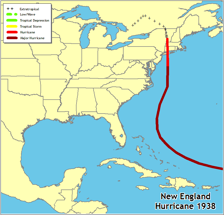
9/21/1938: The Long Island Express, a powerful Category 3 hurricane slams into Long Island and southern New England, causing 600 deaths and devastating coastal cities and towns.
Saturday, September 21st, 2019New England Hurricane 1938
The “Long Island Express” was first detected over the tropical Atlantic on September 13, although it may have formed a few days earlier. Moving generally west-northwestward, it passed to the north of Puerto Rico on the 18th and 19th, likely as a category 5 hurricane. It turned northward on September 20 and by the morning of the 21st it was 100 to 150 miles east of Cape Hatteras, North Carolina. At that point, the hurricane accelerated to a forward motion of 60 to 70 mph, making landfall over Long Island and Connecticut that afternoon as a Category 3 hurricane. The storm became extratropical after landfall and dissipated over southeastern Canada on September 22.
Blue Hill Observatory, Massachusetts measured sustained winds of 121 mph with gusts to 183 mph (likely influenced by terrain). A U.S. Coast Guard station on Long Island measured a minimum pressure of 27.94 in. Storm surges of 10 to 12 ft inundated portions of the coast from Long Island and Connecticut eastward to southeastern Massachusetts, with the most notable surges in Narragansett Bay and Buzzards Bay. Heavy rains before and during the hurricane produced river flooding, most notably along the Connecticut River.
This hurricane struck with little warning and was responsible for 600 deaths and $308 million in damage in the United States.

IMELDA MOVING FARTHER INLAND… …HEAVY RAINS AND LIFE-THREATENING FLASH FLOODING WILL CONTINUE TO SPREAD INLAND OVER SOUTHEAST TEXAS DURING THE NEXT DAY OR TWO
Wednesday, September 18th, 2019![[Key Messages]](https://www.nhc.noaa.gov/storm_graphics/AT11/refresh/AL112019_key_messages+png/024933_key_messages_sm.png)
![[Key Messages]](https://www.nhc.noaa.gov/storm_graphics/AT09/refresh/AL092019_key_messages+png/030116_key_messages_sm.png)
Challenges to Completing Rabies Postexposure Prophylaxis After Hurricane Irma
Tuesday, September 17th, 2019O’Sullivan B, Burke R, Bassaline D. Notes from the Field: Rabies Exposures from Fox Bites and Challenges to Completing Postexposure Prophylaxis After Hurricane Irma — Palm Beach County, Florida, August–September 2017. MMWR Morb Mortal Wkly Rep 2019;68:795–797. DOI: http://dx.doi.org/10.15585/mmwr.mm6836a4external icon
