Archive for May, 2019
People infected with the outbreak strain of E. coli O103, by state of residence, as of May 10, 2019 (n=196)
Wednesday, May 15th, 2019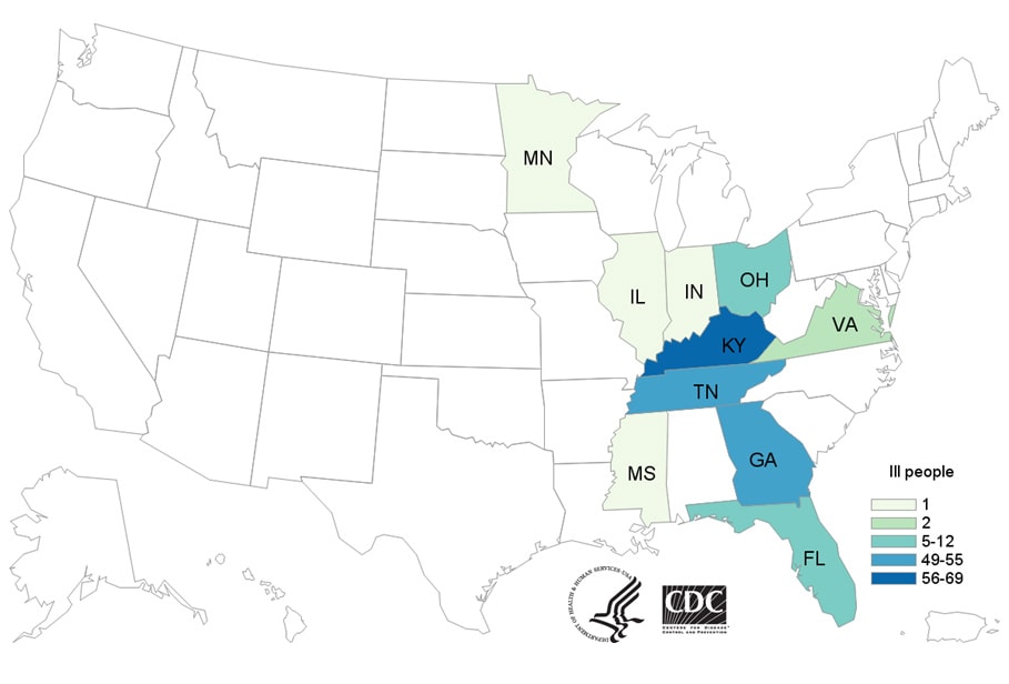
The Mauna Loa Observatory, which has measured the parts per million (ppm) of CO2 in the atmosphere since 1958, took a reading of 415.26ppm in the air on 11 May – thought to be the highest concentration since humans evolved.
Wednesday, May 15th, 2019
Site: https://www.ncdc.noaa.gov/paleo-search/study/6091
DOI: https://doi.org/10.1038/nature06949
Citation: Lüthi, D., M. Le Floch, B. Bereiter, T. Blunier, J.-M. Barnola, U. Siegenthaler, D. Raynaud, J. Jouzel, H. Fischer, K. Kawamura, and T.F. Stocker. 2008. High-resolution carbon dioxide concentration record 650,000-800,000 years before present. Nature, Vol. 453, pp. 379-382, 15 May 2008.
NOAA: Storm surge, the deadliest threat from tropical cyclones
Tuesday, May 14th, 2019")
Credit: NOAA
“……These storm surge hazard mapsoffsite link enable people living in hurricane-prone coastal areas to evaluate their risk of coastal flooding due to storm surge. And don’t forget, storm surge is not just a beachfront problem. The hazard extends many miles inland from the immediate coastline in some areas. Understanding this risk gives you the time to take action when emergency managers tell you to evacuate……”
1. Storm surge is often the greatest threat to life and property from a hurricane. It poses a significant threat for drowning. A mere six inches of fast-moving flood water can knock over an adult. It takes only two feet of rushing water to carry away most vehicles— including pickups and SUVs.
2. Storm surge can cause water levels to rise quickly and flood large areas—sometimes in just minutes, and you could be left with no time to take action if you haven’t already evacuated as instructed.
3. Storm surge values do not correspond well to the hurricane wind categories (of the Saffir-Simpson Hurricane Wind Scale) that range from 1 to 5. These categories are based only on winds and do not account for storm surge.
4. Tropical storms, category 1 or 2 hurricanes, major (category 3 to 5) hurricanes, and post-tropical cyclones can all cause life-threatening storm surge.
5. Storm surge can also occur with non-tropical storms like Nor’easters and other winter storms.
6. Many U.S. Gulf and East Coast areas are vulnerable to storm surge, including areas up to several miles inland from the coastline. Find out today, well before a hurricane ever approaches, if you live in a storm surge evacuation zone.
7. Storm surge can occur before, during, or after the center of a storm passes through an area. Storm surge can sometimes cut off evacuation routes, so do not delay leaving if an evacuation is ordered for your area.
8. During the peak of a storm surge event, it is unlikely that emergency responders will be able to reach you if you are in danger.
9. Even if your community is not directly affected by storm surge, it could experience other hazards from the storm and face dangerous conditions such as impassable roads, water and sewage problems, and power outages. If power remains on, downed electrical wires can pose an electrocution risk.
10. Weather conditions and the forecast can change. Local officials could issue evacuation or other instructions for many reasons. Always follow the instructions of local officials.
Over the weekend and through Monday: The DRC’s ministry of health recorded 56 new Ebola cases, including 4 in healthcare workers, and 19 new deaths.
Tuesday, May 14th, 2019
Hajj Requirements
Tuesday, May 14th, 2019Embassy of Saudi Arabia

Hajj Requirements: (Updated Annually)
5/13/1972: A fire breaks out at the Playtown Cabaret in Osaka, Japan, killing 118.
Monday, May 13th, 2019Burden of emergency medical diseases around the world
Monday, May 13th, 2019Global Medical Emergencies Document
Razzak J, Usmani MF, Bhutta ZA. Global, regional and national burden of emergency medical diseases using specific emergency disease indicators: analysis of the 2015 Global Burden of Disease Study. BMJ Glob Health 2019;4:e000733. doi:10.1136/ bmjgh-2018-000733
“……In general, an emergency condition was defined as those requiring interventions within minutes to hours to reduce the chance of disability and death and improve health outcomes.
Razzak and his team’s results show a 6 percent increase in deaths of adults and children due to emergency conditions between 1990 and 2015. Over the 25-year period, the most significant decrease was found in upper-middle-income countries, and the lowest level of decrease — between 11 and 15 percent — in poorer nations. Overall, the mortality burden of medical emergencies was found to be more than four times to five times higher in low-income countries around the world compared to high-income countries.
Globally, injuries from accidents, falls and burns (22 percent), heart attacks (17 percent), lung infections (11 percent) and strokes (7 percent) made up the top emergency conditions and diseases in 2015. Other conditions such as diarrheal diseases and malaria had a lower overall global burden, but were more prevalent in low-income countries. The analysis also showed that emergency diseases affect men much more than women, and half of all the emergency disease burden was among people younger than 45 years old.
Countries with the lowest mortality and morbidity burden of medical emergencies included Bahrain, Israel and Kuwait, while Chad, Niger and Mali had the highest burdens. China, India and the United States, the three most populous countries studied, were ranked globally at 64th, 144th and 47th out of 195, respectively, in terms of the lowest burden of emergency diseases……”
M 6.1 – 8km N of Canoas, Costa Rica
Monday, May 13th, 2019
Tectonic Summary
Seismotectonics of the Caribbean Region and Vicinity
Extensive diversity and complexity of tectonic regimes characterizes the perimeter of the Caribbean plate, involving no fewer than four major plates (North America, South America, Nazca, and Cocos). Inclined zones of deep earthquakes (Wadati-Benioff zones), ocean trenches, and arcs of volcanoes clearly indicate subduction of oceanic lithosphere along the Central American and Atlantic Ocean margins of the Caribbean plate, while crustal seismicity in Guatemala, northern Venezuela, and the Cayman Ridge and Cayman Trench indicate transform fault and pull-apart basin tectonics.
Along the northern margin of the Caribbean plate, the North America plate moves westwards with respect to the Caribbean plate at a velocity of approximately 20 mm/yr. Motion is accommodated along several major transform faults that extend eastward from Isla de Roatan to Haiti, including the Swan Island Fault and the Oriente Fault. These faults represent the southern and northern boundaries of the Cayman Trench. Further east, from the Dominican Republic to the Island of Barbuda, relative motion between the North America plate and the Caribbean plate becomes increasingly complex and is partially accommodated by nearly arc-parallel subduction of the North America plate beneath the Caribbean plate. This results in the formation of the deep Puerto Rico Trench and a zone of intermediate focus earthquakes (70-300 km depth) within the subducted slab. Although the Puerto Rico subduction zone is thought to be capable of generating a megathrust earthquake, there have been no such events in the past century. The last probable interplate (thrust fault) event here occurred on May 2, 1787 and was widely felt throughout the island with documented destruction across the entire northern coast, including Arecibo and San Juan. Since 1900, the two largest earthquakes to occur in this region were the August 4, 1946 M8.0 Samana earthquake in northeastern Hispaniola and the July 29, 1943 M7.6 Mona Passage earthquake, both of which were shallow thrust fault earthquakes. A significant portion of the motion between the North America plate and the Caribbean plate in this region is accommodated by a series of left-lateral strike-slip faults that bisect the island of Hispaniola, notably the Septentrional Fault in the north and the Enriquillo-Plantain Garden Fault in the south. Activity adjacent to the Enriquillo-Plantain Garden Fault system is best documented by the devastating January 12, 2010 M7.0 Haiti strike-slip earthquake, its associated aftershocks and a comparable earthquake in 1770.
Moving east and south, the plate boundary curves around Puerto Rico and the northern Lesser Antilles where the plate motion vector of the Caribbean plate relative to the North and South America plates is less oblique, resulting in active island-arc tectonics. Here, the North and South America plates subduct towards the west beneath the Caribbean plate along the Lesser Antilles Trench at rates of approximately 20 mm/yr. As a result of this subduction, there exists both intermediate focus earthquakes within the subducted plates and a chain of active volcanoes along the island arc. Although the Lesser Antilles is considered one of the most seismically active regions in the Caribbean, few of these events have been greater than M7.0 over the past century. The island of Guadeloupe was the site of one of the largest megathrust earthquakes to occur in this region on February 8, 1843, with a suggested magnitude greater than 8.0. The largest recent intermediate-depth earthquake to occur along the Lesser Antilles arc was the November 29, 2007 M7.4 Martinique earthquake northwest of Fort-De-France.
The southern Caribbean plate boundary with the South America plate strikes east-west across Trinidad and western Venezuela at a relative rate of approximately 20 mm/yr. This boundary is characterized by major transform faults, including the Central Range Fault and the Boconó-San Sebastian-El Pilar Faults, and shallow seismicity. Since 1900, the largest earthquakes to occur in this region were the October 29, 1900 M7.7 Caracas earthquake, and the July 29, 1967 M6.5 earthquake near this same region. Further to the west, a broad zone of compressive deformation trends southwestward across western Venezuela and central Colombia. The plate boundary is not well defined across northwestern South America, but deformation transitions from being dominated by Caribbean/South America convergence in the east to Nazca/South America convergence in the west. The transition zone between subduction on the eastern and western margins of the Caribbean plate is characterized by diffuse seismicity involving low- to intermediate-magnitude (M<6.0) earthquakes of shallow to intermediate depth.
The plate boundary offshore of Colombia is also characterized by convergence, where the Nazca plate subducts beneath South America towards the east at a rate of approximately 65 mm/yr. The January 31, 1906 M8.5 earthquake occurred on the shallowly dipping megathrust interface of this plate boundary segment. Along the western coast of Central America, the Cocos plate subducts towards the east beneath the Caribbean plate at the Middle America Trench. Convergence rates vary between 72-81 mm/yr, decreasing towards the north. This subduction results in relatively high rates of seismicity and a chain of numerous active volcanoes; intermediate-focus earthquakes occur within the subducted Cocos plate to depths of nearly 300 km. Since 1900, there have been many moderately sized intermediate-depth earthquakes in this region, including the September 7, 1915 M7.4 El Salvador and the October 5, 1950 M7.8 Costa Rica events.
The boundary between the Cocos and Nazca plates is characterized by a series of north-south trending transform faults and east-west trending spreading centers. The largest and most seismically active of these transform boundaries is the Panama Fracture Zone. The Panama Fracture Zone terminates in the south at the Galapagos rift zone and in the north at the Middle America trench, where it forms part of the Cocos-Nazca-Caribbean triple junction. Earthquakes along the Panama Fracture Zone are generally shallow, low- to intermediate in magnitude (M<7.2) and are characteristically right-lateral strike-slip faulting earthquakes. Since 1900, the largest earthquake to occur along the Panama Fracture Zone was the July 26, 1962 M7.2 earthquake.
References for the Panama Fracture Zone:
Molnar, P., and Sykes, L. R., 1969, Tectonics of the Caribbean and Middle America Regions from Focal Mechanisms and Seismicity: Geological Society of America Bulletin, v. 80, p. 1639-1684.
Europe: Over 100 000 people sick with measles in 14 months and over 90 measles-related deaths.
Sunday, May 12th, 2019
Can we survive a war at home?
Sunday, May 12th, 2019Lucie, Quinton. “How FEMA Could Lose America’s Next Great War.” Homeland Security Affairs 15, Article 1 (May 2019). https://www.hsaj.org/articles/15017
“……The United States lacks a comprehensive strategy and supporting programs to support and defend the population of the United States during times of war and to mobilize, sustain and expand its defense industrial base while under attack from a peer or near- peer adversary. These legacy programs were disbanded and broken up over 25 years ago, and without a reinvestment in these activities by the Federal Emergency Management Agency (FEMA) and the Department of Homeland Security (DHS), America risks losing its next great war...….”