Archive for the ‘Volcano’ Category
The Kilauea Volcano on Hawaii’s Big Island erupted May 4 and nearby residents were ordered to evacuate.
Friday, May 4th, 2018HAWAIIAN VOLCANO OBSERVATORY STATUS REPORT
U.S. Geological Survey
Thursday, May 3, 2018, 10:13 PM HST (Friday, May 4, 2018, 08:13 UTC)
KILAUEA VOLCANO (VNUM #332010)
19°25’16” N 155°17’13” W, Summit Elevation 4091 ft (1247 m)
Current Volcano Alert Level: WARNING
Current Aviation Color Code: ORANGE
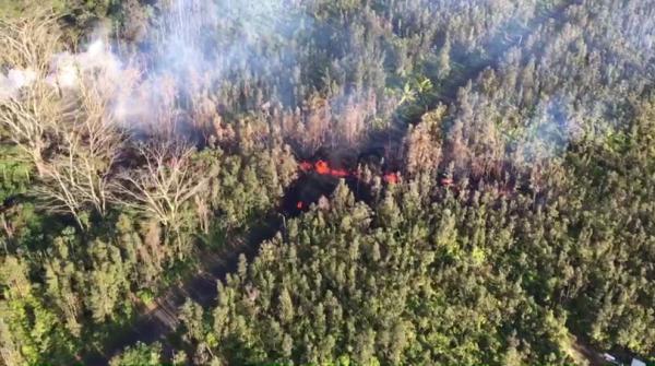
The eruption in the Leilani Estates subdivision in the lower East Rift Zone of Kīlauea Volcano that began in late afternoon ended by about 6:30 p.m. HST. Lava spatter and gas bursts erupted from the fissure for about two hours, and lava spread a short distance from the fissure, less than about 10 m (33 ft).
At this time, the fissure is not erupting lava and no other fissures have erupted.
HVO geologists are working near the fissure overnight to track additional activity that may occur, and other scientists are closely tracking the volcano’s overall activity.
 USGS
USGS
Recent Observations
Geologists reported this evening that the presence of sulfur gas is quite noticeable around the fissure, typical of active and recently active fissures. The concentration of sulfur dioxide gas is high within tens of meters (yards) of the fissure.
Lava flows did not advance more than about 10 m (33 ft) from the fissure. The flows are no longer active.
At this time, no other fissures have erupted from along the rift zone.
Tiltmeters at Kīlauea’s summit continue to record deflationary tilt and the lava lake level has dropped about 37 m (121 ft) in the past 24 hours.
Seismic activity has not changed significantly during the day or since the brief fissure eruption.
Hazard Analysis
The opening phases of fissure eruptions are dynamic and uncertain. Additional erupting fissures and new lava outbreaks may occur. It is not possible at this time to say when and where new vents may occur.
Areas downslope of an erupting fissure or vent are at risk of lava inundation. At this time, the general area of the Leilani subdivision appears at greatest risk.
See the Hawaii County Civil Defense messages and alerts for additional information (http://www.hawaiicounty.gov/active-alerts).
HVO Contact Information: askHVO@usgs.gov
MORE INFORMATION
Activity Summary also available by phone: (808) 967-8862
Lava viewing information:
Hawai’i Volcanoes National Park: https://www.nps.gov/havo/planyourvisit/lava2.htm
County of Hawaii: http://www.hawaiicounty.gov/lava-viewing/
Kalapana lava-viewing area: 808-430-1966
Subscribe to these messages: https://volcanoes.usgs.gov/vns2/
Webcam images: https://volcanoes.usgs.gov/volcanoes/kilauea/multimedia_webcams.html
Photos/Video: https://volcanoes.usgs.gov/volcanoes/kilauea/multimedia_chronology.html
Lava Flow Maps: https://volcanoes.usgs.gov/volcanoes/kilauea/multimedia_maps.html
Definitions of terms used in update: https://volcanoes.usgs.gov/volcanoes/kilauea/extra/definitions.pdf
Overview of Kīlauea summit (Halemaʻumaʻu) and East Rift Zone (Puʻu ʻŌʻō ) eruptions:
https://volcanoes.usgs.gov/volcanoes/kilauea/extra/background.pdf
Summary of volcanic hazards from Kīlauea eruptions:
https://volcanoes.usgs.gov/volcanoes/kilauea/extra/hazards.pdf
Recent Earthquakes in Hawai’i (map and list):
https://volcanoes.usgs.gov/hvo/earthquakes/
Explanation of Volcano Alert Levels and Aviation Color Codes:
https://volcanoes.usgs.gov/activity/alertsystem/index.php
https://pubs.usgs.gov/fs/2006/3139/
HVO Contact: askHVO@usgs.gov
CONTACT INFORMATION:
askHVO@usgs.gov
The Hawaiian Volcano Observatory is one of five volcano observatories within the U.S. Geological Survey and is responsible for monitoring volcanoes and earthquakes in Hawai`i.
Possibility of volcanic eruptions grows in Hawaii with increased low magnitude earthquake activity
Thursday, May 3rd, 2018Hawaii County Civil Defense Agency
“This is a Civil Defense message for Wednesday May 2, 2018 at 6:00 PM.
The Hawaiian Volcanoes Observatory reports continuous low magnitude earthquake activity along the east rift zone in lower Puna which includes Leilani Estates, Nanawale Estates, to the coastal area of Kapoho.
Due to this activity Hawaiian Volcanoes Observatory indicates an eruption is possible. Because it is not possible to predict where an eruption could occur, the areas that could be affected are Nanawale Estates, Leilani Estates or Kapoho.
Due to the possibility of an eruption, the following are issued:
Prepare and review your emergency plans in case you need to evacuate.
Stay informed by listening to local radio stations for Civil Defense updates or call Civil Defense at 935-0031.
Hawaiian Volcanoes Observatories and your Hawaii County Civil Defense will continue to monitor the situation. You will be informed of any conditions that affect your safety.
This is your Hawai’i County Civil Defense Agency.”
May 2, 2018

Starting on the afternoon of Monday, April 30, 2018, magma beneath Pu‘u ‘Ō‘ō drained and triggered the collapse of the crater floor. Within hours, earthquakes began migrating east of Pu‘u ‘Ō‘ō, signaling an intrusion of magma along the middle and lower East Rift Zone. As of about noon on Wednesday, May 2, these earthquakes continue along the lower East Rift Zone, with many reports of earthquakes felt by residents in nearby subdivisions. The orange dashed line marks the approximate area within which most of the earthquakes are located based on automatic earthquake locations and analysis by seismologists. All earthquake locations are preliminary. For more details on the hazards associated with this ongoing event, see this link: https://volcanoes.usgs.gov/volcanoes/kilauea/status.html (see large map)
May 1, 2018
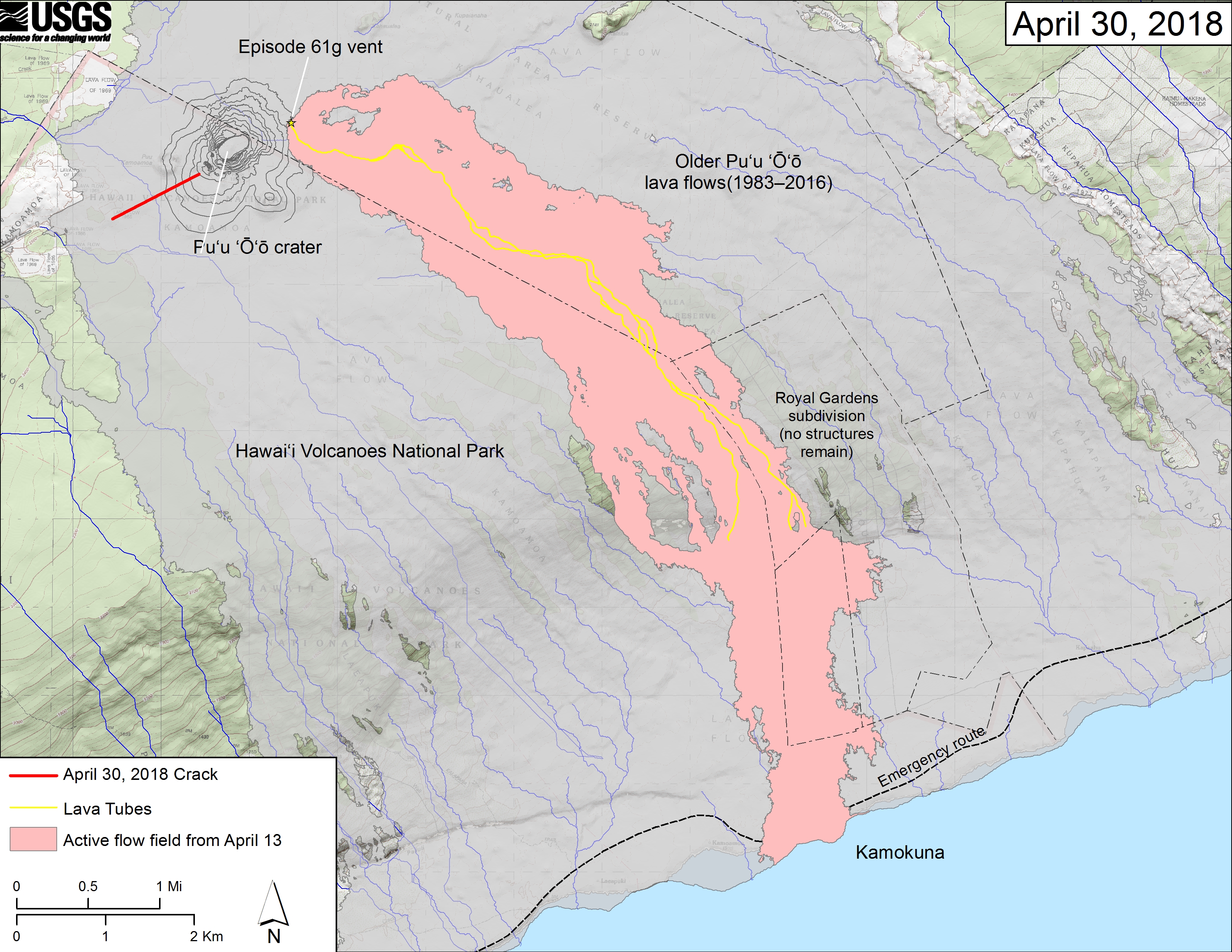
This map shows recent changes to Kīlauea’s East Rift Zone lava flow field and Pu‘u ‘Ō‘ō cone. The 61g flow field, as of April 13, 2018, is shown in pink. The crack that formed on the west side of Pu‘u ‘Ō‘ō on April 30th, 2018, during or immediately after the crater floor collapse is shown as a solid red line. Older Pu‘u ‘Ō‘ō lava flows (1983–2016) are shown in gray. The yellow line is the trace of the active lava tubes. The Kamokuna ocean entry is inactive. The blue lines over the Pu‘u ‘Ō‘ō flow field are steepest-descent paths calculated from a 2013 digital elevation model (DEM), while the blue lines on the rest of the map are steepest-descent paths calculated from a 1983 DEM (for calculation details, see http://pubs.usgs.gov/of/2007/1264/). Steepest-descent path analysis is based on the assumption that the DEM perfectly represents the earth’s surface. DEMs, however, are not perfect, so the blue lines on this map can be used to infer only approximate flow paths. The base map is a partly transparent 1:24,000-scale USGS digital topographic map draped over the 1983 10-m digital elevation model (DEM). (see large map) (see large map) (see large map) (see large map)
Heavy eruptions of the Tambora volcano in Indonesia over the course of days killed over 100 000.
Tuesday, April 17th, 2018“….. In subsequent months, more than 80,000 people died in the surrounding area from starvation due to the resulting crop failures and disease…..”
3/8/1669: Mount Etna begins rumbling and multiple eruptions over the next few weeks kills more than 20,000 people and leaves thousands more homeless.
Thursday, March 8th, 2018Almost 36,000 people have fled to temporary shelters as of Tuesday morning, following eruptions of the restive Mayon Volcano
Tuesday, January 23rd, 2018The Philippine Institute of Volcanology and Seismology (PHIVOLCS) declared alert level 4 which warns of an imminent hazardous eruption — possibly within days.
Monday, January 22nd, 2018Level 5 means a hazardous eruption is taking place.