Archive for the ‘Volcano’ Category
USGS Volcano Glossary
Saturday, May 12th, 2018A
B
Basalt
Basaltic andesite
Base surge
Batholith
Benchmark
Bishop Tuff
Block and ash flow
Bomb
Breadcrust Bomb
C
D
E
Effusive eruption
Ejecta
Emission
Eruption column
Explosive eruption
Extensional tectonic environment
G
H
I
K
L
M
O
P
Kilauea: Definitions of Volcanic Terms (USGS)
Saturday, May 12th, 2018• DI event: “DI” is short for “deflation-inflation.” A DI event is an abrupt deflation of Kīlauea’s summit that lasts from several hours to 2-3 days, followed by an abrupt transition to inflation that effectively cancels the preceding deflation over the ensuing hours to days. DI events are best recorded by tiltmeters at Kīlauea’s summit, which typically measure a few microradians (see definition below) of change for individual events. DI events indicate a decrease and subsequent increase in pressure within a magma reservoir located about 1.5 km (1 mi) beneath the east margin of Halema‘uma‘u Crater. The level of the summit lava lake generally tracks tilt during DI events, with the lava level dropping during the deflation phase and rising during the inflation phase. Many DI events at Kīlauea’s summit are also recorded, after a delay of minutes to hours, by a tiltmeter on the north flank of Pu‘u ‘Ō‘ō on Kīlauea’s East Rift Zone, which is a sign that the pressure changes at the summit are being transmitted through the magma conduit to the East Rift Zone eruption site. DI events sometimes correlate with pauses and pulses in lava output from East Rift Zone eruptive vents. For more information, please go to: http://hvo.wr.usgs.gov/volcanowatch/view.php?id=117 http://hvo.wr.usgs.gov/howwork/subsidence/inflate_deflate.html
• Glow: Light from an unseen source; indirect light.
• Halema‘uma‘u Overlook: This visitor overlook, located on the southeast rim of Halema‘uma‘u Crater, has been closed to the public since early 2008, when sulfur dioxide gas emissions increased to hazardous levels. After the summit vent opened within Halema‘uma‘u Crater in March 2008, the visitor overlook area became even more hazardous. High levels of sulfur dioxide gas can pose an immediate danger to health and life, and intermittent explosive eruptions blast rock and lava fragments (some large enough to cause serious injury or death) from the vent on to the crater rim.
• Overlook vent or Overlook crater: The informal name of Kīlauea Volcano’s active summit vent. This vent is a crater within the floor of Halema‘uma‘u Crater, which, in turn, is within the floor of the larger Kīlauea caldera (also sometimes referred to as a crater). When the summit vent first opened in March 2008, it was about 35 m (115 ft) in diameter. It has since enlarged due to collapses of the overhung vent rim, and, as of May 2015, was about 215 m (705 ft) by 165 m (540 ft) in size. From November 2009 to present, the summit vent has hosted a lava lake that has risen and fallen dramatically over time, with lake levels that have ranged from about 200 m (655 ft) below the vent rim (e.g., in January 2010) to overflowing the vent rim (e.g., in April-May 2015). Lava lake level fluctuations—rising with summit inflation and dropping with summit deflation— are an ongoing process. For more information, please go to: http://pubs.usgs.gov/fs/2013/3116/
• Incandescence: Visible light emitted from a hot surface. The color of the light is related to surface temperature. Molten lava displays bright orange to orange-yellow light from surfaces that
are hotter than 900 degrees Celsius (1,650 degrees Fahrenheit). Some surfaces can display dull red incandescence at temperatures as low as 430 degrees Celsius (806 degrees Fahrenheit). • Jaggar Museum Overlook (or observation deck): Perched on the rim of Kīlauea Volcano’s summit caldera, about 1.6 km (1 mi) north-northwest of the active summit vent within Halema‘uma‘u Crater, the Jaggar Museum Overlook (observation deck) affords spectacular views of Kīlauea’s summit vent activity. The Thomas A. Jaggar Museum is located on Crater Rim Drive in Hawai‘i Volcanoes National Park about 4 km (2.5 mi) from the Kīlauea Visitor Center. For more information, please visit: http://www.nps.gov/havo/planyourvisit/jaggar_museum.htm
• Metric ton (t): A unit of weight or mass equal to 1,000 kilograms, 2,204.6 lbs, or 1.102 US (short) tons. Used to report gas measurements.
• Microradian: The amount of tilt or ground deformation on volcanoes is measured in microradians. One microradian of tilt is equivalent to the angle created by raising one end of a 1km- (0.6-mi-) long board by the thickness of a U.S. dime (1 mm, or 0.04 in). More specifically, a microradian is a measure of angle equivalent to 0.000057 degrees. For more information about tilt, please visit: http://volcanoes.usgs.gov/activity/methods/deformation/tilt/. http://hvo.wr.usgs.gov/kilauea/update/deformation.php http://hvo.wr.usgs.gov/volcanowatch/archive/2002/02_05_30.html
• Tephra: The general term for volcanic rock fragments exploded or carried into the air during an eruption. Such fragments can range in size from less than 2 mm (0.08 inches) to more than 1 m (3.2 feet) in diameter. The smallest tephra is called volcanic ash, pieces of pulverized rock and volcanic glass the size of sand or silt. Tiny ash particles can be less than 0.001 mm (0.00004 inches) in diameter. For more information about tephra, please visit: http://hvo.wr.usgs.gov/hazards/FAQ_SO2-Vog-Ash/P2.html#ash http://volcanoes.usgs.gov/hazards/tephra/ http://volcanoes.usgs.gov/images/pglossary/tephra.php http://volcanoes.usgs.gov/hazards/tephra/tephraterms.php
• Tonne (t): An old spelling for “metric ton,” a unit that is used to report gas measurements.
For more definitions of volcanic terms (with photos), please see: http://volcanoes.usgs.gov/images/pglossary/
EARTHQUAKE TERMS:
• LPs: Long-period (LP) events refer to a type of earthquake with a drawn-out, wave-like pattern when viewed on seismic records (seismograms). LP earthquakes are attributed to motion of fluids (gas, water, and/or magma) within conduits, cracks, and chambers beneath the ground surface, and have a gentler, rolling motion that is difficult for humans to detect. Most earthquakes that people feel are short-period events associated with rupture of a fault, with chaotic, rapid changes in ground motion. On seismograms, LP earthquakes are recognized by the relatively even spacing between adjacent peaks on the record. This spacing—or period—can be between 0.2 and 2 seconds
(frequencies of 0.5 to 5 Hz), compared to short-period earthquakes, which are characterized by periods that are fractions of a second. LP earthquakes are also known at other volcanoes as low-frequency earthquakes, tornillos, or B-type earthquakes
• VLPs: Very-long-period (VLP) events are earthquakes similar to LP events, but with much longer periods (that is, more time between adjacent peaks on a seismic record)—typically between 20 and 100 seconds (frequencies between 0.01 and 0.05 Hz). If LP earthquakes are analogous to waves on the ocean, then VLP earthquakes are like ocean swells. VLPs can only be detected by specially designed seismometers, since the “shaking” is so gentle. At Kīlauea, VLP earthquakes are common and associated with magma and gas migration through a constriction located near a shallow magma reservoir about 1.5 km (1 mi) beneath Halema‘uma‘u Crater.
• Composite seismic event: A composite seismic event records several processes occurring one after another—a combination of short-period, long-period (LP) and very-long-period (VLP) earthquakes that occur as part of a single, drawn-out event. These events have been recorded frequently at Kīlauea since the start of the current summit eruption in March 2008, and are usually associated with rockfalls into the summit lava lake (as seen by HVO cameras). Composite seismic events typically begin like “normal” short-period earthquakes, with chaotic shaking indicating the occurrence of a rockfall and small explosion as the rockfall makes contact with the lava lake. After a few seconds, the seismic signature transitions to an LP event as gas is released from the upper part of the lava lake. The disturbance in the column of lava in the lake is felt all the way down to a small magma chamber beneath the summit, where it triggers the release of VLP energy that follows the LP event. Thus, a composite seismic event begins like a normal earthquake, but transitions to an LP and then a VLP event, the latter of which can last for several minutes before the energy dissipates completely.
• Volcanic tremor: Active volcanoes are characterized by continuous release of seismic energy as fluids (magma, gas, and/or water) move through subsurface conduits, as gas is released from magma, and/or as lava erupts at the surface. This background seismic “hum” of the volcano is called volcanic tremor. Volcanic tremor is frequently associated with gas and lava output and is often a sign that a volcano is erupting or is on the verge of erupting. Volcanic tremor is distinguished from earthquakes by its sustained nature, lasting from minutes to days and fluctuating in intensity, depending on the activity of the volcano. Harmonic tremor refers to volcanic tremor displaying a steady or dominant period associated with ground shaking. Spasmodic tremor features bursts of energy.
OTHER TERMS / HAWAIIAN WORDS:
• CD: Hawai‘i County Civil Defense
• Mauka / makai: Hawaiian terms for directions relative to the coast. Makai or ma kai is toward the coast, and mauka or ma uka is toward the highlands, or away from the coast.
• Pali: Hawaiian term for cliff or precipice.
Kilauea: 1,700 people have been evacuated, and many homes have been consumed by fire.
Saturday, May 12th, 2018HAWAIIAN VOLCANO OBSERVATORY STATUS REPORT
U.S. Geological Survey
Friday, May 11, 2018, 4:39 PM HST (Saturday, May 12, 2018, 02:39 UTC)
KILAUEA VOLCANO (VNUM #332010)
19°25’16” N 155°17’13” W, Summit Elevation 4091 ft (1247 m)
Current Volcano Alert Level: WARNING
Current Aviation Color Code: ORANGE
Lower East Rift Zone Eruption
Volcanic unrest in the lower East Rift Zone of Kīlauea Volcano continues. While no lava has been emitted from any of the 15 fissure vents since May 9, earthquake activity, ground deformation, and continuing high emission rates of sulphur dioxide indicate additional outbreaks of lava are likely. The location of future outbreaks is not known with certainty, but could include areas both uprift (southwest) and downrift (northeast) of the existing fissures, or resumption of activity at existing fissures. Communities downslope of these fissures could be at risk from lava inundation.
Residents in lower Puna should remain informed and heed Hawaii County Civil Defense closures, warnings, and messages (http://www.hawaiicounty.gov/active-alerts).
For maps showing the locations of eruption features, please see https://volcanoes.usgs.gov/volcanoes/kilauea/multimedia_maps.html
For information on volcanic air pollution, please see: http://www.ivhhn.org/vog/
Kīlauea Volcano Summit
Tiltmeters at the summit of Kīlauea Volcano continue to record deflationary tilt. Based on this and field observations of the past two days, the lava lake level continues to drop. Rockfalls from the steep crater walls have generated small ash clouds mixed with white condensed water vapor intermittently throughout the day. These ash clouds have been relatively low concentration and have risen only a few thousand feet above the ground generating very localized ashfall. More explosive activity generating larger ash clouds remains possible.
Earthquake activity in the summit remains elevated. Many of these earthquakes are related to the ongoing subsidence of the summit area and earthquakes beneath the south flank of the volcano.
For information on volcanic ash, please see: https://volcanoes.usgs.gov/volcanic_ash/
MORE INFORMATION
Activity Summary also available by phone: (808) 967-8862
Subscribe to these messages: https://volcanoes.usgs.gov/vns2/
Webcam images: https://volcanoes.usgs.gov/volcanoes/kilauea/multimedia_webcams.html
Photos/Video: https://volcanoes.usgs.gov/volcanoes/kilauea/multimedia_chronology.html
Lava Flow Maps: https://volcanoes.usgs.gov/volcanoes/kilauea/multimedia_maps.html
Definitions of terms used in update: https://volcanoes.usgs.gov/volcanoes/kilauea/extra/definitions.pdf
Overview of Kīlauea summit (Halemaʻumaʻu) and East Rift Zone (Puʻu ʻŌʻō ) eruptions:
https://volcanoes.usgs.gov/volcanoes/kilauea/extra/background.pdf
Summary of volcanic hazards from Kīlauea eruptions:
https://volcanoes.usgs.gov/volcanoes/kilauea/extra/hazards.pdf
Recent Earthquakes in Hawai’i (map and list):
https://volcanoes.usgs.gov/hvo/earthquakes/
Explanation of Volcano Alert Levels and Aviation Color Codes:
https://volcanoes.usgs.gov/activity/alertsystem/index.php
https://pubs.usgs.gov/fs/2006/3139/
CONTACT INFORMATION:
askHVO@usgs.gov
The Hawaiian Volcano Observatory is one of five volcano observatories within the U.S. Geological Survey and is responsible for monitoring volcanoes and earthquakes in Hawai`i.
Sulfur Dioxide Leaks from Kilauea
Wednesday, May 9th, 2018
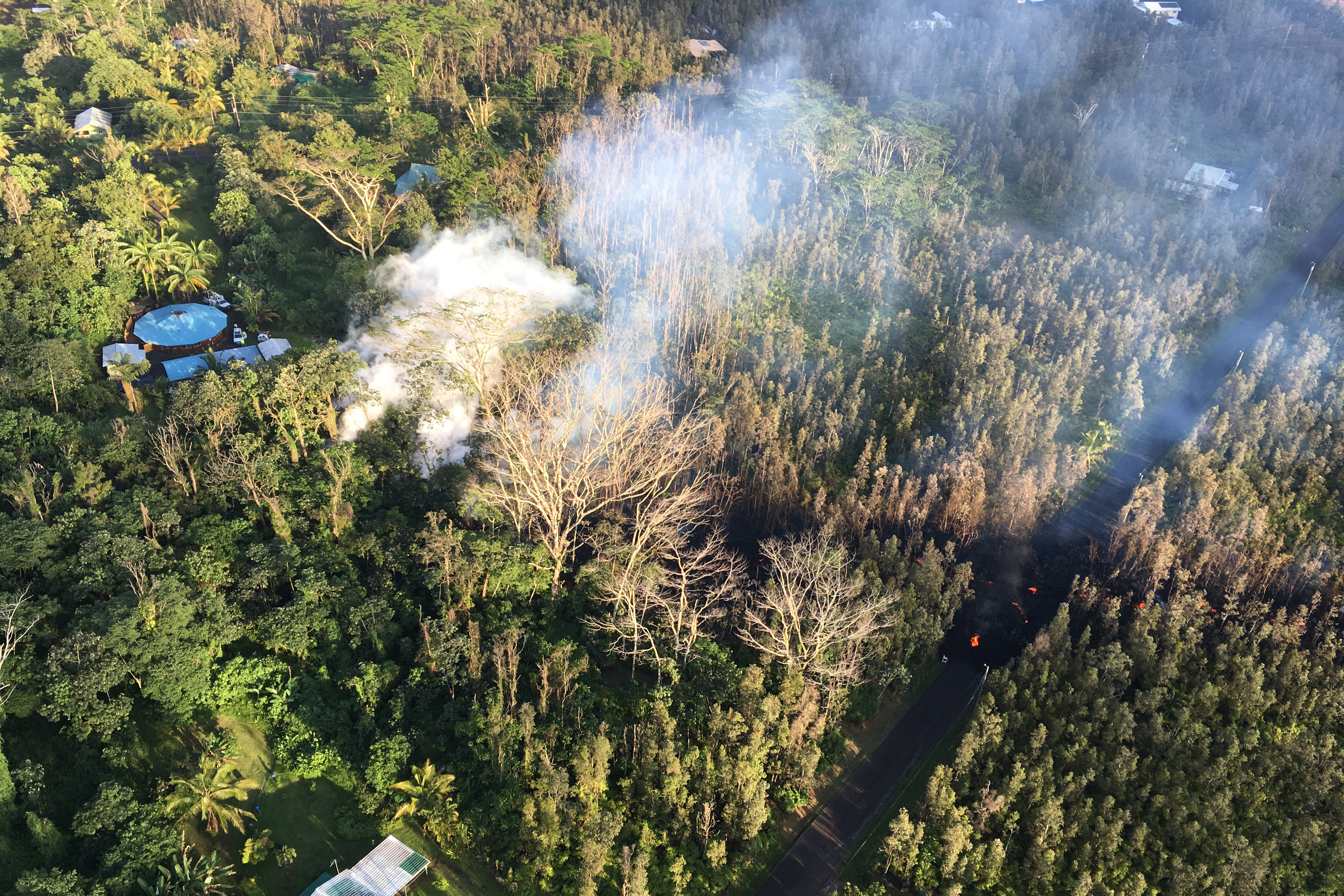
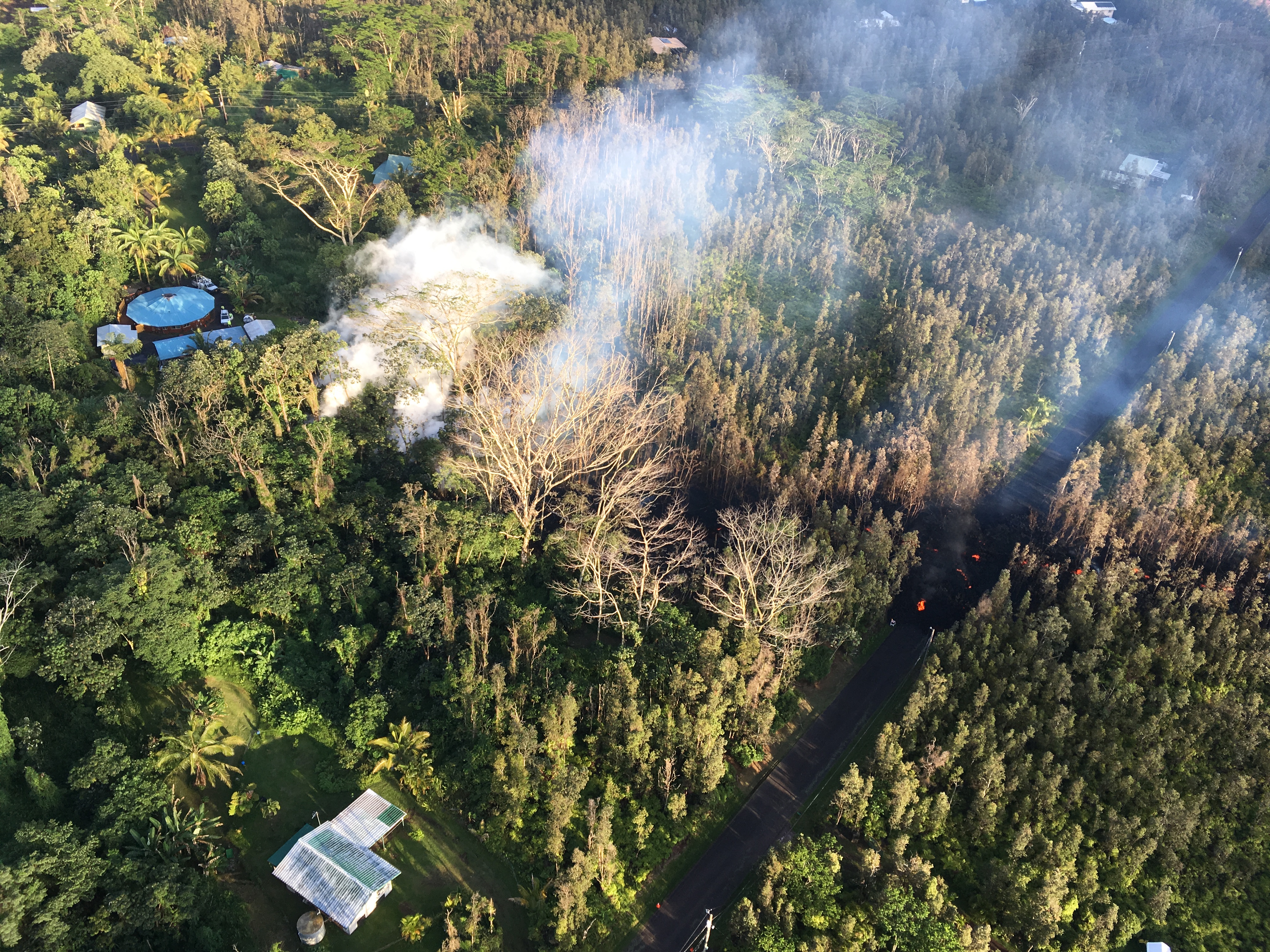
Kilauea has been erupting continuously since 1983, but in late April and early May 2018 the volcanic eruption took a dangerous new turn.
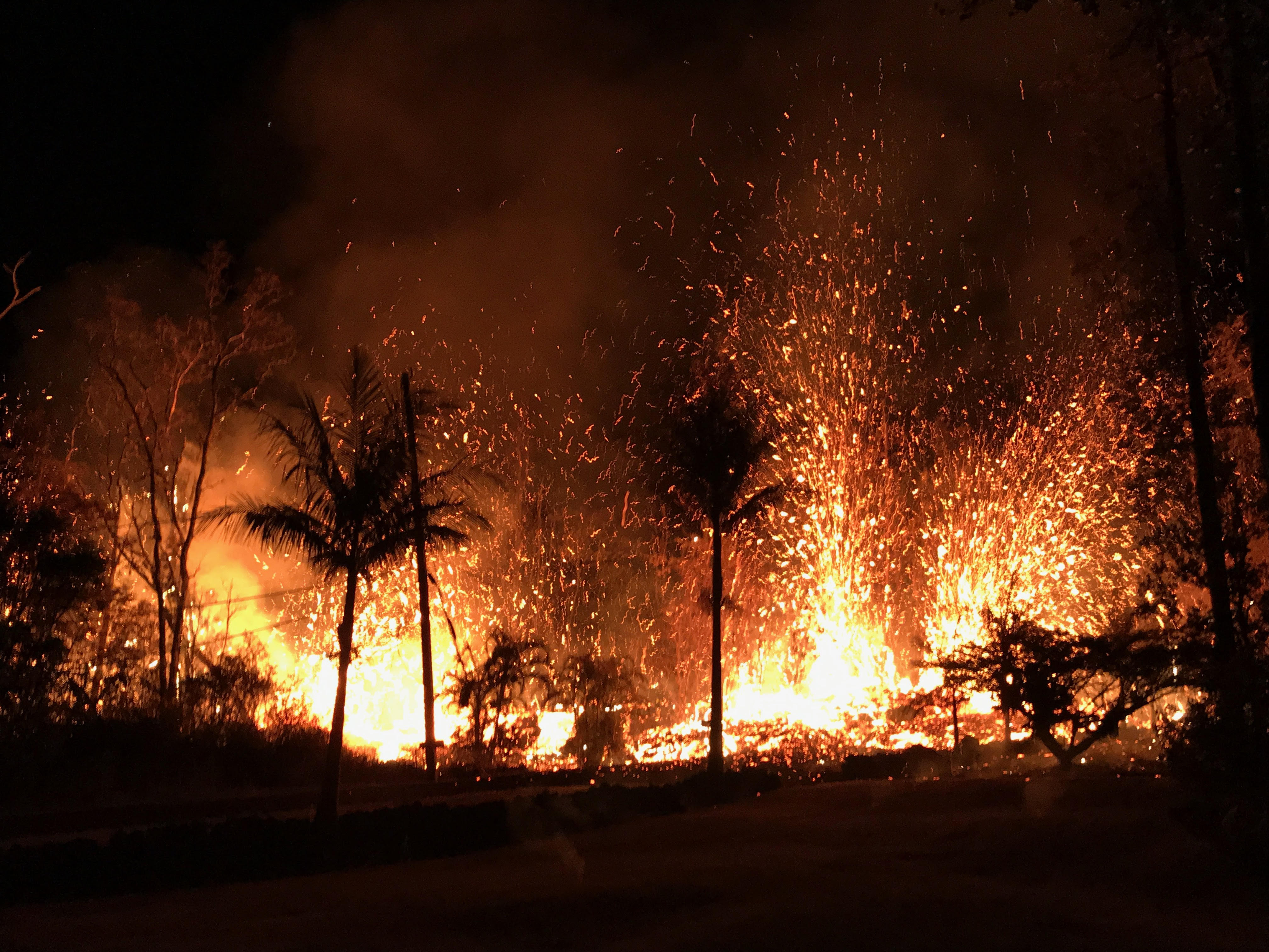
During the last week of April, the lava lake at Halema‘uma‘u Overlook crater overflowed several times and then began to drain rapidly after the crater floor partially collapsed. Soon after, a swarm of earthquakes spread across Kilauea’s East Rift Zone as magma moved underground. On May 3, 2018, several new fissures cracked open the land surface in the Leilani Estates subdivision, leaking gases and spewing fountains of lava. As of May 7, 2018, slow-moving lava flows had consumed 35 homes in that community of 1,500 people.
In addition to seismic activity and deformation of the land surface, another sign of volcanic activity is increased emission of sulfur dioxide (SO2), a toxic gas that occurs naturally in magma. When magma is deep underground, the gas remains dissolved because of the high pressure. However, pressure diminishes as magma rises toward the surface, and gas comes out of solution, or exsolves, forming bubbles in the liquid magma.
“The process is similar to what happens when a bottle of soda is opened,” explained Ashley Davies, a volcanologist at NASA’s Jet Propulsion Laboratory. “The bubbles of sulfur dioxide and other volatiles, including water and carbon dioxide, begin to rise through the liquid magma and concentrate in the magma closest to the surface, so the first lava to erupt is often the most volatile-rich. There’s usually an increase in sulfur dioxide output right before lava reaches the surface, as the gas escapes from the ascending magma.”
Sensors onboard the Ozone Mapping Profiler Suite (OMPS) sensor on the Suomi NPP satellite have begun to detect signs of activity at Kilauea. The series of images above shows elevated concentrations of sulfur dioxide on May 5, a few days after the new fissures opened up. The second chart (below) underscores the significant natural variability in sulfur dioxide emissions as observed by OMPS over Hawaii between January and May 2018.
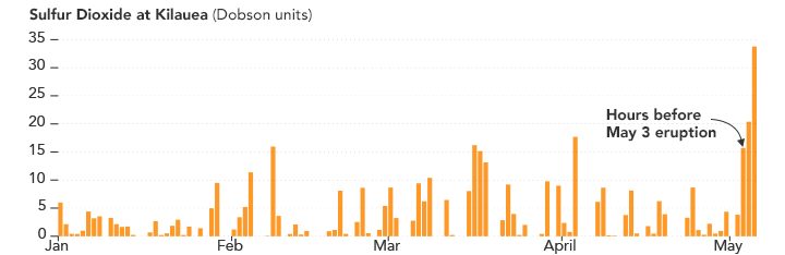
“Interpreting the satellite SO2 data for events like this is complicated because there are multiple SO2 sources that combine to form the volcanic sulfur dioxide plume. Kilauea volcano has several sources of sulfur dioxide degassing: the summit caldera (a significant source since 2008); the Pu’u ‘O’o vent on the East Rift Zone; and now the new eruption site in Leilani Estates,” said Simon Carn, a volcanologist at Michigan Tech. “It can be very hard to distinguish individual ‘plumes’ from these sulfur dioxide sources with the spatial resolution that we have from OMPS, but we are seeing what seems to be an overall increase that coincides with the latest activity.”
Another satellite-based sensor—the Advanced Spaceborne Thermal Emission and Reflection Radiometer (ASTER) on NASA’s Terra satellite—observed SO2 emissions on on May 6, 2018. When ASTER passed over Hawaii, the largest source of SO2 appeared to be coming from Kilauea’s summit crater, but there was also a sizable plume streaming southwest from the fissures in Leilani Estates. So far, trade winds have pushed the toxic gas offshore, but Hilo and other communities northwest of Leilani Estates could see air quality deteriorate if the trade winds weaken.
-
References and Further Reading
- County of Hawaii (2018, May 7) East Rift Zone Eruption in Leilani Estates Update. Accessed May 8, 2018.
- Discover (2018, May 6) Rocky Planet: Lava Flows and Sulfur Dioxide Threaten Leilani Estates on Kilauea. Accessed May 8, 2018.
- Forbes (2018, May 6) NASA Satellites Track Harmful Sulfur Dioxide From The Mt. Kilauea Eruption. Accessed May 8, 2018.
- Global Volcanism Program Kilauea. Accessed May 8, 2018.
- In the Company of Volcanoes (2018, May 3) Communicating volcanoes: resources for media. Accessed May 8, 2018.
- NASA Applied Sciences Kilauea, Hawaii Eruption 2018. Accessed May 8, 2018.
- NASA Earth Observatory Volcanic Activity at Kilauea.
- NASA Jet Propulsion Laboratory (2018, May 7) NASA Satellite detects Kilauea Fissures. Accessed May 8, 2018.
- United States Geological Survey Kilauea. Accessed May 8, 2018.
- Weather Underground (2018, May 7) More than Lava: The Dangerous Fumes Belched Out by Volcanoes. Accessed May 8, 2018.
NASA Earth Observatory images by Joshua Stevens, using OMPS data from the Goddard Earth Sciences Data and Information Services Center (GES DISC). Photo courtesy of the U.S. Geological Survey. Story by Adam Voiland, with information from Simon Carn (Michigan Tech), Nickolay Krotkov (NASA Goddard Space Flight Center), Ashley Davies (NASA Jet Propulsion Laboratory), Janine Krippner (Concord University), and Jean-Paul Vernier (NASA Langley Research Center).
FEMA’s report on the Kilauea eruption in Hawaii (May 8, 2018)
Tuesday, May 8th, 2018Situation On May 3, a lava flow broke to the surface in lower Puna on the Big Island of HI.
Since the onset of this eruption, a total of 12 fissures have emerged.
Multiple earthquakes/aftershocks of magnitude 2.5 or higher recorded in the past week; but earthquake activity has diminished by approximately 33% from May 6
Impacts
• Evacuations: 1,650 residents of Leilani Estates & Lanipuna Gardens (775 homes) under mandatory evacuation; Leilani Estates allowed limited, short-term reentry
• Shelters: 2 shelters open / 147 occupants (Region IX Update #5 as of 6:37 p.m. EDT May 7)
• Damage: 35 homes destroyed; no major damage to critical infrastructure (CIKR)
• Temporary Flight Restrictions for non-relief aircraft operations extended to May 15
• Pahoa-Pahoiki road closed from Highway 132 to Highway 137
State / Local Response
• HI EOC at Partial Activation
• Governor declared State of Emergency & activated HI National Guard
• State is working to restore water service to neighborhoods near the fissures
FEMA Response
• FEMA Region IX RWC & Pacific Area Watch at Steady State; continue to monitor
• Four FEMA Region IX LNOs deployed to HI EOC & Hawai‘i County Civil Defense
• N-IMAT East 1 at Region IX; deploying to Hawai‘i County over the next two days
• FEMA NWC is monitoring
USGS: Volcanic air pollution hazards in Hawaii
Tuesday, May 8th, 2018
Elias, T., and Sutton, A.J., 2017, Volcanic air pollution hazards in Hawaii: U.S. Geological Survey Fact Sheet 2017–3017, 4 p., https://doi.org/10.3133/fs20173017.
“…..Noxious sulfur dioxide gas and other air pollutants emitted from Kīlauea Volcano on the Island of Hawai‘i react with oxygen, atmospheric moisture, and sunlight to produce volcanic smog (vog) and acid rain. Vog can negatively affect human health and agriculture, and acid rain can contaminate household water supplies by leaching metals from building and plumbing materials in rooftop rainwater-catchment systems. …..”
The number of homes destroyed by Hawaii’s Kilauea volcano jumps to 26
Monday, May 7th, 2018
On May 3, 2018, ash, lava, and gas erupted from Hawaii’s Kilauea volcano. Clouds have so far prevented NASA satellites from acquiring a natural-color image of the area. However, the plume contained sulfur dioxide (SO2), a gas that was detected by the Ozone Mapper Profiler Suite (OMPS) on the Suomi-NPP satellite.
The map above shows concentrations of SO2 as detected by OMPS at 1:30 p.m. local time (23:30 Universal Time) on May 3. Maximum gas concentrations reached 15 Dobson Units.
Sulfur dioxide is invisible to our eyes, but it can affect human health and Earth’s climate. The gas reacts with water vapor in the atmosphere to produce acid rain. It also can react with other gases to form aerosol particles that cause haze and, in extreme events, climate cooling.
According to the USGS Hawaiian Volcano Observatory, activity that continued on May 4 was primarily “lava spattering” from at least three small fissure vents in the Leilani Estates subdivision. News reports note that residents of the subdivision were ordered to evacuate.
-
References and Further Reading
- USGS Volcano Hazards Program (2018, May 3) Hawaiian Volcano Observatory. Accessed May 4, 2018.
- USGS Volcano Hazards Program (2018, May 4) Hawaiian Volcano Observatory Daily Update. Accessed May 4, 2018.
- The Washington Post (2018, May 4) Hawaii’s Kilauea erupts. Evacuations underway as lava threatens communities. Accessed May 4, 2018.
NASA Earth Observatory image by Joshua Stevens, using OMPS data from the Goddard Earth Sciences Data and Information Services Center (GES DISC). Text by Kathryn Hansen.
USGS: Kilauea Update
Sunday, May 6th, 2018HAWAIIAN VOLCANO OBSERVATORY DAILY UPDATE
U.S. Geological Survey
Saturday, May 5, 2018, 11:54 AM HST (Saturday, May 5, 2018, 21:54 UTC)
KILAUEA VOLCANO (VNUM #332010)
19°25’16” N 155°17’13” W, Summit Elevation 4091 ft (1247 m)
Current Volcano Alert Level: WARNING
Current Aviation Color Code: ORANGE
 USGS
USGS
Summary: Active eruption of lava and gas continues along Kīlauea Volcano’s lower East Rift Zone within the Leilani Estates subdivision. Additional fissure vents producing spatter and small lava flows developed early this morning, and additional outbreaks in the area are likely. Deflationary tilt at the summit of the volcano continues and the lava lake level continues to drop. There is no active lava in the Puʻu ʻŌʻō area. Aftershocks from yesterday’s M6.9 earthquake continue and more should be expected, with larger aftershocks potentially producing rockfalls and associated ash clouds above Puʻu ʻŌʻō and Halemaʻumaʻu Crater.
Photos and maps of activity will be posted to the HVO web site as soon as possible. https://volcanoes.usgs.gov/volcanoes/kilauea/multimedia_chronology.html
 USGS
USGS
Residents of the Puna District should remain alert, review individual, family, and business emergency plans, and watch for further information about the status of the volcano.
Hawaii County Civil Defense messages regarding conditions, warning, and evacuations may be found at http://www.hawaiicounty.gov/active-alerts/.
Summit Observations: Deflationary tilt at the summit continues. In concert, the summit lava lake is dropping. Tremor amplitude is fluctuating with lava lake spattering. No large rockfalls or ash plumes related to rockfalls into the lava lake, such as occurred yesterday during the large earthquake sequence, have occurred. Elevated summit sulfur dioxide emission rates persist. Gas emissions remain elevated. Current webcam views are here: https://volcanoes.usgs.gov/volcanoes/kilauea/multimedia_webcams.html
Puʻu ʻŌʻō Observations: Seismicity remains elevated at Puʻu ʻŌʻō but tiltmeters near the cone show no significant deformation overnight. No lava is active in the area and the 61g lava flow is no longer being fed. The summit crater of the cone will likely continue to collapse intermittently producing small plumes of ash. Yesterday, there were several vigorous episodes of ash emission in response to collapse, including immediately after the nearby M6.9 earthquake.
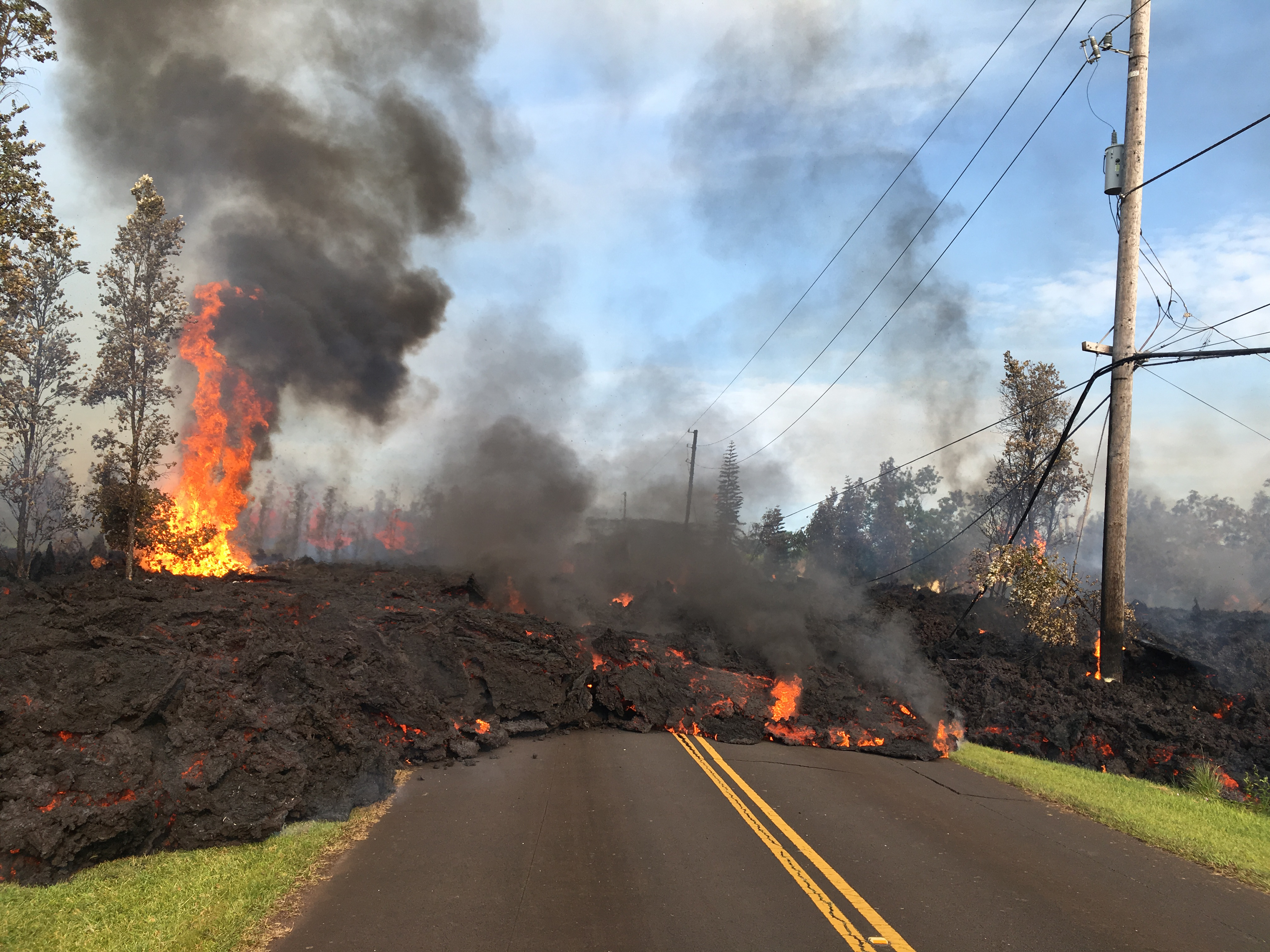
Hazard Analysis: Additional fissure outbreaks producing spatter and lava flows are likely. Locations cannot be forecast with certainty, but new outbreaks thus far have been preceded by ground cracking, then strong steam and volcanic gas release. Areas uprift and downrift of the current fissure zone are the most likely to see further outbreaks.
Areas downslope of an erupting fissure or vent are at risk of lava inundation. Currently, lava flows from active fissures are sluggish and not moving very quickly or far. The general area of the Leilani subdivision remains at greatest risk. However, as the eruption progresses, other areas of the lower East Rift Zone may also be at risk.
High levels of volcanic gas including sulphur dioxide are being emitted from the fissure vents. In addition, smoke from burning houses and burning asphalt is a health concern and should be avoided.
As the lava lake level inside Halemaʻumaʻu drops, rockfalls from the enclosing walls may increase in frequency prompting explosions of spatter from the lake onto the nearby crater rim and lofting plumes of ash. Dustings of ash from these events can occur downwind. Yesterday’s strong earthquakes were responsible for some of these plumes and associated ashfall, both from Kīlauea Volcano’s summit lava lake and the Puʻu ʻŌʻō vent.
Additional aftershocks from yesterday’s M6.9 earthquake are expected and some may be strong. Residents are advised to review earthquake preparedness by consulting available resources such as: https://www.shakeout.org/hawaii/dropcoverholdon/
Earthquakes, as big as 6.9M, have hit Hawaii’s Big Island, one day after the eruption of the Kilauea volcano.
Saturday, May 5th, 2018


USGS: All about Kilauea
Friday, May 4th, 2018Kīlauea Volcano is a shield volcano located on the eastern slope of Mauna Loa Volcano on the Island of Hawai‘i. The volcano is considered to be in the shield-building stage of Hawaiian volcanism.
")
There is a lack of old exposed rock at Kīlauea, which makes it difficult for geologists to piece together its complete eruption history. Only about 10 percent of Kīlauea’s surface consists of rock older than 1,000 years. The other 90 percent of the volcano’s surface is covered by lava flows younger than 1,000 years, and about 20 percent of those flows are less than 200 years old. The Hilina Basalt formation, exposed in Hilina fault scarps on Kīlauea’s central south flank, includes the oldest lava flows found above sea level, which erupted around 50,000 to 70,000 years ago.
Older rocks have been recovered from Kīlauea’s submarine slopes and drill cores, providing some clues to the volcano’s origin. Estimates for the age of Kīlauea’s first-erupted lavas continue to evolve as more samples are collected and various dating methods are used. Current research indicates the first alkali-basalt lava flows erupted onto the ocean floor between 210,000 and 280,000 years ago, and the volcano transitioned from its pre-shield to shield-building stage about 155,000 years ago.
Geologic mapping and dating of Kīlauea’s surface tells of cyclic eruption styles
")
Long periods of explosive (tephra-dominated) and effusive (lava-flow-dominated) activity have alternated at Kīlauea for the past 2,500 years. Scientists infer that the eruption style is determined by the amount of magma being supplied to the volcano. When magma supply is high, the summit caldera fills and feeds voluminous lava flows from summit and rift zone vents. When the magma supply drops, the caldera collapses. When the caldera floor is deep enough to be at or near the water table (about 500 m (1640 ft) deeper than present), water can seep into the vent to trigger steam explosions. Eventually magma supply increases, and effusive eruptions dominate as many lava flows fill the caldera and erupt from the rift zones.
Prolonged periods of explosive eruptions at Kīlauea may require the presence of a caldera to sustain them. Scientists estimate that during Kīlauea’s past 2,500 years a deep caldera has existed about 60 percent of the time, which included two long periods of sporadic violent explosions. One lasted 1,200 years, ending in about 1000 CE; the other lasted 300 years, between about 1500 and 1800 CE.
Caldera collapse 2,200 years ago ushered in 1,200 years of explosive eruptions
Since Kīlauea’s surface is dominantly covered by young deposits, only the eruption record of the past 2,500 years is suitably well-known. Effusive lava flows were the norm until about 2,200 years ago, when the Powers caldera formed—the precursor to the present-day summit caldera. The caldera collapsed to a depth of at least 620 m (2030 ft), where magma and external water interacted to trigger powerful phreatomagmatic (water plus magma) eruptions. Numerous explosive eruptions lasted for a period of about 1,200 years, producing the Uwekahuna tephra. Sometime between 850 and 950 CE, the most powerful explosive eruption known to have occurred from Kīlauea sent rocks weighing 4.4 kg (9.7 lbs) at least 5 km (3 mi) from the summit. Golf ball-sized rocks fell at the coast, 18 km (11 mi) away.
Lava Flows from 1000 to 1500 CE built the Observatory shield and ‘Ailā‘au flow
 wide. Kīlauea Volcano, Hawai‘i.
(Click image to view full size.)")
Lava flows finally began to erupt again about 1,000 years ago, breaking the 1,200-year-long interval dominated by explosive eruptions. Lava completely filled the summit caldera, then overflowed to form a new shield—the Observatory shield—in place of the caldera. Flows spilled into the surrounding forest, which had grown during the previous centuries, and lava also erupted frequently along the volcano’s east and southwest rift zones. Some archaeologists think people first arrived on the island in the beginning half of the 13th century, 200 to 250 years after the Observatory shield started to form.
Construction of the shield ended around the year 1400 CE. Soon after, lava erupted from a vent on the east side of the shield near the present-day Thurston lava tube (Nāhuku). This effusive eruption lasted for about 60 years, the longest-lasting lava flow witnessed by human inhabitants in Hawai‘i. Known as the ‘Ailā‘au flow, it covered much of Kīlauea, from the summit to the coast on the north side of the East Rift Zone, with some lava spilling southward to the modern Keauhou Landing.
Caldera formation marks transition from effusive to explosive phase
.
(Click image to view full size.)")
The present-day Kīlauea caldera formed by collapse just after the ‘Ailā‘au eruption ended (about 1470 CE) and before the Keanakāko‘i eruptions began (about 1510 CE). The caldera floor dropped to a depth of about 600 m (1970 ft), with diameters of 3.5 km (2.2 mi) by 3 km (1.9 mi), which is estimated to be a collapse volume of 4 to 6 km3 (1 to 1.4 mi3). Traditional Hawaiian chants suggest that Hi‘iaka, a sister of the volcano deity Pele, dug a deep caldera after the ‘Ailā‘au eruption. This oral tradition describes the caldera’s formation by a dramatic collapse of the volcano’s summit area.
So, how did the caldera form? To trigger a collapse, material must be removed from the magma reservoir within the volcano, creating a void into which the overlying rocks fall. The volume of lava erupted during the 60-year ‘Ailā‘au eruption matches the inferred caldera collapse volume. Perhaps incremental collapses occurred as the magma storage region gradually emptied, then eventually led to a final large collapse as described in Hawaiian chants. It is possible that toward the end of the ‘Ailā‘au eruption, the dwindling magma supply failed to replenish the magma storage system, which collapsed as it emptied.
Kīlauea’s most recent explosive period lasted 300 years
 of ash southwest of Kīlauea's summit.
(Click image to view full size.)")
Towering lava fountains, likely more than 600 m (2,000 ft) high, roared from Kīlauea caldera just after it formed and began 300 years of explosive eruptions that ended in the early 19th century. During that time, at least four strong explosive eruptions sent tephra high into the jet stream, with ash falling over a broad area east and offshore of the volcano. This eruptive period blanketed the summit area with an 11-m- (35-ft-) thick deposit known as the Keanakāko‘i tephra.
Near the end of this explosive period in 1790, a series of explosive eruptions sent searing pyroclastic surges at least 3.5 km (2.1 mi) down the west side of the summit area. This was the deadliest eruption known from a U.S. volcano (but at the time, it was the Hawaiian Kingdom). Several hundred (and perhaps more than a few thousand) people were killed within a few hundred meters of where the Hawaiian Volcano Observatory and the National Park’s Jaggar Museum are located today. The unfortunate victims died as a result of the hot, ash-rich surge that both suffocated and burned them.
Current effusive period has lasted about 200 years, but it will switch back again
")
Only a few lava flows were erupted during the 300 years of explosive activity, but that changed in 1823, when the volcano reverted to an effusive interval that continues to this day. Since then, Kīlauea’s summit caldera has been slowly filling with lava flows, and, at a depth of 120 m (400 ft) today, much shallower than its past depth of at least 600 m (2000 ft). In addition to summit eruptions, numerous lava fountains and lava flows have issued from vents along the volcano’s southwest and east rift zones.
")
The first explosive eruption on the volcano since the early 19th century took place in 1924 within Halema‘uma‘u Crater on the floor of Kīlauea’s summit caldera. The eruption occurred days after the active lava lake drained away, with the magma probably intruding into the volcano’s East Rift Zone. For 17 days, rocks, ash, and dust erupted in dramatic clouds rising from the crater. Rocks weighing many tons were hurled as far as a kilometer (0.6 mi) from the crater. There was some subsidence within Halema‘uma‘u, but the caldera did not deepen appreciably. Within two months, lava reappeared in the crater and above the level of the water table, which inhibited additional large steam explosions. Although the period of explosive eruptions was brief and violent, they were small compared to those between 1500 and 1800.
Having pieced together the recent geologic past of Kīlauea, scientists conclude that the volcano will eventually return to a long period of mostly explosive activity, just as it did around 1500 CE. This future explosive period will probably accompany a significant decrease in the magma supply rate and be initiated by collapse of a new caldera to the depth of the water table, which today is about 615 m (2015 ft) below the present high point on the caldera rim. For now, effusive eruptions dominate Kīlauea.