Archive for May, 2016
The blaze, which has scorched more than 602 square miles and ravaged Fort McMurray, is approaching the neighboring province of Saskatchewan
Sunday, May 8th, 2016Control of Canine Rabies in Ethiopia, 2015: Challenges Galore!
Sunday, May 8th, 2016
Notes from the Field: Assessment of Health Facilities for Control of Canine Rabies — Gondar City, Amhara Region, Ethiopia, 2015
Weekly / May 6, 2016 / 65(17);456–457
Emily G. Pieracci, DVM1,2; Betsy Schroeder, MPH3; Araya Mengistu, DVM, PhD4; Achenef Melaku, DVM4; Miriam Shiferaw, MD5; Jesse D. Blanton, MPH5; Ryan Wallace, DVM5
Rabies is an encephalitic disease that is nearly always fatal after onset of illness. Worldwide, rabies kills an estimated 59,000 humans each year (95% confidence interval [CI] = 25,000–159,000); the majority of the deaths are caused by the rabies virus variant that circulates in dogs (1,2). Canine rabies is endemic in Ethiopia, with an estimated 2,771 human deaths annually (CI = 1,116–12,660) (1–3). Annual rabies-associated livestock losses are estimated at >$50 million (USD), making rabies important to both human and animal health (1).
Human health care delivery in Ethiopia occurs through hospitals, health centers, and health posts. The Ethiopian government runs veterinary clinics, and some private veterinarians operate in large cities; however, human and animal health providers do not routinely collaborate to control zoonotic diseases. The World Organisation for Animal Health’s Tool for the Evaluation of Performance of Veterinary Services identified a need to improve animal disease surveillance as well as collaboration on zoonotic diseases between the Ministry of Health and veterinary services in Ethiopia (4).
Dog bites are nationally notifiable in Ethiopia and bite victims are referred to health centers for rabies postexposure prophylaxis (PEP). No additional public health interventions occur at the community level. In an integrated bite-case management (IBCM) program, animal health workers would investigate biting dogs to provide the health sector with information for rabies risk assessments. Studies have shown that IBCM can increase bite detection rates by up to 30% and decrease unnecessary PEP by 60% (5). Because IBCM represents integration of both human and animal health, it offers an opportunity to prevent human rabies deaths as well as decrease the high costs of unnecessary PEP.
In January 2015, CDC, in collaboration with Ohio State University, the University of Gondar (Amhara Region, Ethiopia), and the Ethiopian Public Health Institute developed an IBCM pilot program in the city of Gondar. Bite events are reported from human health sectors to animal health workers, who conduct animal rabies assessments to guide management decisions for exposed persons. Program goals include recording dog bites, testing suspected rabid dogs, and reducing community rabies exposures.
In September 2015, a CDC team evaluated the IBCM pilot program and assessed the feasibility of program expansion. The evaluation included informal interviews with animal health workers, laboratorians, and program supervisors, and field observation of animal health workers. The feasibility assessment included semi-structured interviews with key stakeholders at human and animal health facilities and evaluation of infrastructural requirements necessary for IBCM program expansion (i.e., cold-chain capacity, sample transportation, and access to rabies vaccines).
Delays in the distribution of funds and shortages of PEP slowed program implementation during the first 9 months. In addition, the preference of community members to seek bite-wound treatment from traditional healers rather than health professionals resulted in a low dog-bite reporting rate. Rabies diagnostic testing capacity was lacking, related to delays in construction of a regional animal disease diagnostic center. Quarantine facilities for suspected rabid dogs did not adhere to international animal welfare regulations; therefore, most suspected rabid animals were quarantined within owners’ homes. Inconsistencies in animal health workers’ handling of animals, including euthanasia practices and sample collection, also hampered implementation. Resource gaps included inadequate access to PEP and canine vaccines and a lack of cold-chain capacity.
Despite the implementation challenges, efforts were undertaken to enhance IBCM capacity in Gondar through training of additional animal health workers, laboratorians, and program supervisors. Ethiopia has regional and national plans to increase access to PEP and canine rabies vaccine during the next year. A national animal rabies surveillance system, based on IBCM, is being jointly developed by human and animal health agencies with CDC support, and will be implemented in the Amhara Region during 2016. Construction of the rabies laboratory is under way, and temporary diagnostic laboratory space has been identified. Construction of regional quarantine facilities is expected to begin in 2016. During the feasibility assessments, the IBCM program was introduced to clinicians unaware of this activity.
Further work is needed to increase community reporting of suspected rabid dogs through improved awareness of the IBCM program. Expanded access to WHO-approved PEP is needed, but distribution of vaccine should be limited to facilities with stable cold-chain capacity. Traditional healers should be encouraged to refer dog-bite victims for PEP, and health clinics and veterinary facilities should coordinate IBCM investigations. Enhancement of the IBCM program is anticipated to continue as the program is introduced in new areas.
Corresponding author: Emily G. Pieracci, epieracci@cdc.gov, 404-639-2603.
References
- Hampson K, Coudeville L, Lembo T, et al. . Estimating the global burden of endemic canine rabies. PLoS Negl Trop Dis 2015;9:e0003709. CrossRef PubMed
- Jemberu WT, Molla W, Almaw G, Alemu S. Incidence of rabies in humans and domestic animals and people’s awareness in North Gondar Zone, Ethiopia. PLoS Negl Trop Dis 2013;7:e2216.CrossRef PubMed
- Paulos A, Eshetu Y, Bethelhem N, et al. A study on the prevalence of animal rabies in Addis Ababa during 1999–2002. Ethiopian Veterinary Journal 2002;7:69–77.
- World Organisation for Animal Health (OIE). OIE tool for the evaluation of performance of veterinary services. 6th ed. Paris, France: World Organisation for Animal Health; 2013.http://www.oie.int/fileadmin/Home/eng/Support_to_OIE_Members/pdf/PVS_A_Tool_Final_Edition_2013.pdf
- Wallace RM, Reses H, Franka R, et al. Establishment of a high canine rabies burden in Haiti through the implementation of a novel surveillance program. PLoS Negl Trop Dis 2015;9:e0004245.CrossRef PubMed
Suggested citation for this article: Pieracci EG, Schroeder B, Mengistu A, et al. Notes from the Field. Assessment of Health Facilities for Control of Canine Rabies — Gondar City, Amhara Region, Ethiopia, 2015. MMWR Morb Mortal Wkly Rep 2016;65:456–457. DOI: http://dx.doi.org/10.15585/mmwr.mm6517a4.
It’s alive! In the past eight weeks, more than 130 small earthquakes have trembled beneath the surface of Mount St. Helens.
Saturday, May 7th, 2016
Location: Washington, Skamania County
Latitude: 46.2° N
Longitude: 122.18° W
Elevation: 2,549 (m) 8,363 (f)
Volcano type: Stratovolcano
Composition: Basalt to Rhyodacite
Most recent eruption: 1980, 2004-2008
Nearby towns: Castle Rock, WA; Olympia, WA; Vancouver, WA; Yakima, WA; Portland, OR
Threat Potential: High *
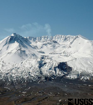
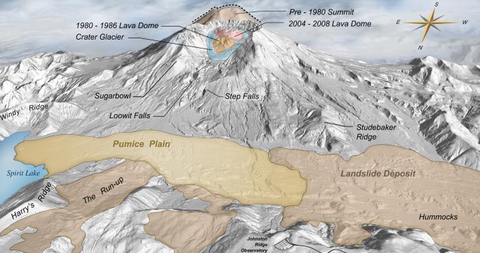
Prior to 1980, Mount St. Helens had the shape of a conical, youthful volcano sometimes referred to as the Mount Fuji of America. During the 1980 eruption the upper 400 m (1,300 ft) of the summit was removed by a huge debris avalanche, leaving a 2 x 3.5 km (1.2 x 2.2 mi) horseshoe-shaped crater now partially filled by a lava dome and a glacier. It is primarily an explosive dacite volcano with a complex magmatic system.
Mount St. Helens was formed during four eruptive stages beginning about 275,000 years ago and has been the most active volcano in the Cascade Range during the Holocene. Prior to about 12,800 years ago, tephra, lava domes, and pyroclastic flows were erupted, forming the older St. Helens edifice, but a few lava flows extended beyond the base of the volcano. The bulk of the modern edifice (above the 1980 crater floor) was constructed during the last 3,000 years, when the volcano erupted a wide variety of products from summit and flank vents. Historical eruptions in the 19th century originated from the Goat Rocks area on the north flank, and were witnessed by early settlers. New unpublished data on the timing for Mount St. Helens eruptive activity have been analyzed, which improves some of the eruption dates cited in published literature. This website contains the most up to date information.
Fort McMurray: A family watches as their living room goes up in flames on a security camera they had installed in their home.
Saturday, May 7th, 2016https://www.youtube.com/watch?v=bD5FHqtFO1Y
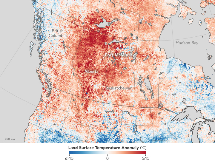
NASA: “….Winds gusted over 20 miles (32 kilometers) per hour, fanning the flames in an area where rainfall totals have been well below normal in 2016. Ground-based measurements showed that the temperature soared to 32 degrees Celsius (90 degrees Fahrenheit) on May 3 as the fire spread.
Satellite observations also detected the unusual heat. The map above shows land surface temperature from April 26 to May 3, 2016, compared to the 2000–2010 average for the same one-week period. Red areas were hotter than the long-term average; blue areas were below average. White pixels had normal temperatures, and gray pixels did not have enough data, most likely due to cloud cover…..”
Alberta’s Fort McMurray Wildfire Update and Resources as of May 5, 2016
Friday, May 6th, 2016Alberta Agriculture and Forestry
Fort McMurray Wildfire Updates

Recent Critical Updates
May 5, 9:20 p.m. Official update:
- Anzac/Gregoire Lake Estates remains an active zone. Further details won’t be available until the morning.
- The Stone Creek Area remains an active fire zone.
- The Birchwood Trails remains a priority from a strategic firefighting standpoint. Crews are working hard to protect this area.
- Gusting winds have been extremely challenging for fire crews.
- Properties near green areas remain an issue due to sparks and high winds creating spot fires among housing.
- A plan is being developed for northern evacuees
- Wildfire Emergency Resources
Regional Municipality of Wood Buffalo
The RMWB is sharing information on the wildfire, the status of evacuations and the status of neighbourhoods as quickly as possible. Follow our social media resources for up-to-date information:
RMWB on Twitter
RMWB on Facebook
RCMP
If you are in Wood Buffalo and need immediate assistance, call 911.
Safety concerns only: 780-788-4000
Wildfire Information Line
310-4455
Open daily from 7 a.m. to 10 p.m.
Alberta Government Emergency Information
http://www.alberta.ca/emergency.cfm
Red Cross
Redcross.ca
Registration: 1-888-350-6070
Twitter: @RedCrossAB
Insurance inquiries
Contact your insurance provider, or call the Insurance Bureau of Canada’s consumer information line: 1-844-227-5422 or FortMacFire@ibc.ca
SPCA
Animal Assistance Form
Fort McMurray SPCA Facebook Page
Emergency Income Support
24 hours
1-866-644-5135
780-644-5135 Edmonton
Government of Canada EI Claims notice for affected workers
Calgary Evacuee Reception Centre
With Fort McMurray and Wood Buffalo evacuees arriving in Calgary, a reception centre has been established at:
Southern Alberta Institute of Technology [Map]
Residence Tower
151 Doctor Carpenter Circle NW
Calgary
Edmonton Hotels Offering “Compassionate Rates”
As of Thursday afternoon. (Rates vary by hotel and are available on an “asked-for” basis.)
| 0 | = Sold Out | |||||
| NR | = No Response | |||||
| NO | = Not Open | |||||
| Rooms Available | ||||||
|---|---|---|---|---|---|---|
| May | May | May | May | May | May | |
| Company | 5th | 6th | 7th | 8th | 9th | 10th |
| West End Hotels | ||||||
| Best Western Plus Westwood Inn | 0 | 42 | 76 | 105 | 110 | 110 |
| Chateau Nova Yellowhead | 0 | 15 | 17 | 53 | 54 | 44 |
| Comfort Inn West | NR | NR | NR | NR | NR | NR |
| Continental Inn | 0 | 0 | 0 | 0 | 0 | 0 |
| Courtyard by Marriott Edm West | 33 | 19 | 27 | 83 | 63 | 46 |
| Days Inn & Suites West | NR | NR | NR | NR | NR | NR |
| DoubleTree by Hilton West Edmonton | 0 | 0 | 0 | 0 | 0 | 0 |
| Edmonton Marriott River Cree | 50 | 80 | 80 | 80 | 80 | 80 |
| Executive Royal Inn | 0 | 100 | 149 | 179 | 186 | 195 |
| Hampton Inn & Suites | 0 | 0 | 0 | 50 | 30 | 25 |
| Hilton Garden Inn West | NR | NR | NR | NR | NR | NR |
| Holiday Inn Express West | 0 | 0 | 0 | 75 | 75 | 75 |
| Holiday Inn & Suites | 0 | 0 | 17 | 40 | 26 | 42 |
| Home2 Suites by Hilton | 0 | 0 | 0 | 0 | 0 | 0 |
| Travelodge Hotel West | 15 | 72 | 91 | 144 | 176 | 176 |
| Staybridge Suites West Edmonton | 0 | 0 | 1 | 29 | 5 | 3 |
| Quality Inn West Edmonton (formerly West Harvest Inn) | 0 | 0 | 30 | 50 | 70 | 75 |
| Nova Acheson | 4 | 17 | 47 | 48 | 51 | 58 |
| Wingate Inn | 0 | 0 | 12 | 45 | 65 | 64 |
| Southside Hotels | ||||||
| Best Western Cedar Park Inn | 0 | 0 | 54 | 142 | 157 | 153 |
| Campus Tower Suites Hotel | 0 | 0 | 0 | 9 | 9 | 6 |
| Days Inn Edmonton South | 0 | 0 | 40 | 75 | 85 | 85 |
| Delta Edmonton South Hotel | 0 | 0 | 38 | 150 | 122 | 68 |
| Four Points Sheraton | 0 | 0 | 0 | 0 | 0 | 0 |
| Four Points Sheraton Edmonton Gateway | 0 | 0 | 0 | 50 | 45 | 45 |
| Holiday Inn Conference Centre Edmonton South | 9 | 29 | 34 | 141 | 168 | 154 |
| Hampton Inn Edmonton South | NR | NR | NR | NR | NR | NR |
| Lister Hall at U of A | 0 | 0 | 0 | 0 | 0 | 0 |
| Metterra Hotel | 0 | 42 | 34 | 50 | 26 | 19 |
| Radisson Hotel Edmonton South | 0 | 0 | 0 | 115 | 130 | 95 |
| Renaissance Edmonton Airport Hotel | 0 | 35 | 35 | 35 | 35 | 35 |
| Sawridge Inn Edmonton | 0 | 0 | 0 | 70 | 40 | 15 |
| Selkirk at Fort Edmonton Park | NO | NO | NO | NO | NO | NO |
| Super 8 Edmonton South | NR | NR | NR | NR | NR | NR |
| Travelodge Edmonton South | 0 | 20 | 20 | 20 | 20 | 20 |
| Varscona Hotel | 0 | 18 | 26 | 56 | 57 | 42 |
| Downtown Hotels | ||||||
| Chateau Nova Kingsway | 0 | 0 | 10 | 10 | 10 | 15 |
| Chateau Lacombe | 5 | 10 | 10 | 85 | 85 | 35 |
| Coast Edmonton Plaza | 50 | 50 | 50 | 50 | 50 | 50 |
| Courtyard by Marriott | 0 | 27 | 58 | 98 | 90 | 0 |
| Days Inn Downtown | 0 | 50 | 50 | 50 | 50 | 50 |
| Delta Edmonton Centre Suites | 70 | 80 | 62 | 82 | 20 | 20 |
| Fairmont Hotel Macdonald | 16 | 0 | 47 | 91 | 58 | 0 |
| Holiday Inn Express | 0 | 13 | 23 | 50 | 80 | 47 |
| MacEwan University Residences | NR | NR | NR | NR | NR | NR |
| Matrix | 15 | 30 | 29 | 100 | 40 | 20 |
| Ramada Inn & Conference Centre | 0 | 14 | 60 | 157 | 224 | 168 |
| Sutton Place Hotel | 25 | 75 | 60 | 160 | 156 | 139 |
| Union Bank Inn | 10 | 10 | 10 | 10 | 10 | 0 |
| Westin Hotel | 50 | 50 | 50 | 50 | 50 | 0 |
| Total Rooms | 352 | 898 | 1347 | 2887 | 2808 | 2274 |
Calgary Hotels Reporting Available Accommodations
The City of Calgary, in conjunction with the Calgary Hotel Association, has compiled a list of hotels that indicated availability as of 5 p.m. on Thursday.
| Name | Street | Phone |
|---|---|---|
| Acclaim Hotel | 123 Freeport Boulevard NE | 403-291-8000 |
| Aloft Calgary University | 2359 Banff Trail NW | 403-338-4401 |
| Best Western Airport Inn | 1947 – 18 Avenue NE | 403-250-5015 |
| Best Western PLUS Calgary Centre Inn | 3630 Macleod Trail South | 403-287-3900 |
| Best Western PLUS Suites Downtown | 1330 – 8 Street SW | 403-209-3444 |
| Best Western Port O’Call Hotel | 1935 McKnight Boulevard NE | 403-291-4600 |
| Best Western Village Park Inn | 1804 Crowchild Trail NW | 403-220-1813 |
| Calgary Marriott Downtown Hotel | 110 – 9 Avenue SE | 403-231-4520 |
| Carriage House Inn | 9030 Macleod Trail South | 403-640-7504 |
| Centro Motel | 4540 – 16 Avenue NW | 403-968-3799 |
| Clarion Hotel & Conference Centre, Calgary Airport | 2120 – 16 Avenue NE | 403-250-6050 |
| Coast Plaza Hotel & Conference Centre | 1316 – 33 Street NE | 403-207-8119 |
| Country Inn & Suites By Carlson, Calgary Airport | 2481 – 39 Avenue NE | 403-250-1800 |
| Courtyard By Marriott Calgary Airport | 2500 – 48 Avenue NE | 403-613-7006 |
| Courtyard By Marriott Calgary South | 3750 Market Street SE | 403.463.0945 |
| Days Inn Calgary Airport | 2799 Sunridge Way NE | 403-250-3297 |
| Days Inn Calgary Northwest | 4420 – 16 Avenue NW | 403-288-7115 |
| Days Inn Calgary South | 3828 Macleod Trail South | 403-243-5531 |
| Deerfoot Inn & Casino | 1000, 11500 – 35 Street SE | 403-236-7529 |
| Delta Calgary Airport | 2001 Airport Road NE | 403-250-6027 |
| Delta Calgary Downtown. | 209 – 4 Avenue SE | 403-205-5409 |
| Delta Calgary South | 135 Southland Drive SE | 403-225-5808 |
| EconoLodge Inn & Suites University | 2231 Banff Trail NW | 403-220-9286 |
| Executive Royal Hotel | 2828 – 23 Street NE | 403-219-7483 |
| Fairfield Inn & Suites | 239 – 12 Ave SW | 403-351-6500 |
| Fairmont Palliser, The | 133 – 9 Avenue SW | 403-260-1202 |
| Four Points By Sheraton Calgary Airport | 2875 Sunridge Way NE | 403-648-3180 |
| Four Points By Sheraton Calgary West | 8220 Bowridge Crescent NW | 403-681-4822 |
| Glenmore Inn & Convention Centre | 2770 Glenmore Trail SE | 403-720-5280 |
| Grey Eagle Resort & Casino | 3779 Grey Eagle Dr | 587-390-6935 |
| Hampton Inn & Suites Airport | 2000 2021 100 Ave | (403) 250-4667 |
| Hilton Garden Inn Calgary Airport | 2335 Pegasus Road NE | 403-717-0150 |
| Holiday Inn Calgary Airport | 1250 McKinnon Drive NE | 403-313-3384 |
| Holiday Inn Calgary Macleod Trail South | 4206 Macleod Trail South | 403-287-1435 |
| Homewood Inn & Suites Airport | 2000 2021 100 Ave | 403-230 7881 |
| Hotel Alma | 169 University Gate NW | 403-220-7472 |
| Hotel Arts | 119 – 12 Avenue SW | 403-266-7677 |
| Hotel Blackfoot | 5940 Blackfoot Trail SE | 403-212-1732 |
| Hotel Elan | 1122 – 16 Avenue SW | 403-826-1352 |
| Hotel Le Germain | 899 Centre Street South | 403-444-1371 |
| Hyatt Regency Calgary | 700 Centre Street South | 403-537-4400 |
| International Hotel Suites Calgary | 220 – 4 Avenue SW | 403-290-7870 |
| Kensington Riverside Inn | 1126 Memorial Drive NW | 403-228-4442 |
| Lakeview Signature Inn, Calgary Airport | 2622 39 Ave NE | 403-735-3230 #4011 |
| O Hotel Suites | 346 23 Ave SW | |
| Radisson Hotel Calgary Airport | 6620 36 Street NE | 403-475-1111 |
| Ramada Hotel Downtown Calgary | 708 – 8 Avenue SW | 403-218-3026 |
| Ramada PLAZA Calgary Airport Hotel & Conference Centre | 3515 – 26 Street NE | 403-250 8855 |
| Regency Suites | 610 – 4 Avenue SW | 403-231-1000 |
| Residence Inn By Marriott Calgary Airport | 2530 – 48 Avenue NE | 403-613-7006 |
| Residence Inn By Marriott Calgary South | 3750 Market Street SE | 403.463.0945 |
| Sandman Hotel Calgary Airport | 25 Hopewell Way NE | 403-219-2478 |
| Sandman Hotel Calgary City Centre | 888 – 7 Avenue SW | 403-513-2526 |
| Sandman Hotel Calgary South | 8001 – 11th Street SE | 403-252 7263 |
| Sandman Hotel Calgary West | 125 Bowridge Drive NW | 403-202-6503 |
| Service Plus Inn & Suites | 3503 – 114 Avenue SE | 403-203-4311 |
| Sheraton Cavalier | 2620 – 32 Avenue NE | 403-291-0107 |
| Sheraton Suites Calgary Eau Claire | 255 Barclay Parade SW | 403-517-6623 |
| Travelodge Hotel Calgary Airport | 2750 Sunridge Boulevard NE | 403-291 4375 |
| Travelodge Hotel Calgary Macleod Trail | 9206 Macleod Trail South | 403-255 6740 / 587-432-0356 (m) |
| Travelodge Calgary University | 2227 Banff Trail NW | 403 879 1543 |
| Thriftlodge Calgary North | 2304 – 16 Avenue NW | 403 289 0211 |
| Westin Calgary | 320 – 4 Avenue SW | 403-508-5200 |
| Wingate by Wyndham Calgary Airport | 57 Freeport Crescent NE | 587-393-0700 |
| Wingate by Wyndham Calgary South | 400 Midpark Way SE | 403-254-3554 |
| Wyndham Garden Calgary Airport | 11 Freeport Crescent NE | 403-516-2266 |
The 328 square-mile fire at Fort McMurray has forced 88,000 people to evacuate
Friday, May 6th, 2016** “….More than 1,110 firefighters, 145 helicopters and 22 air tankers are fighting the fires…..”

Acquired May 3
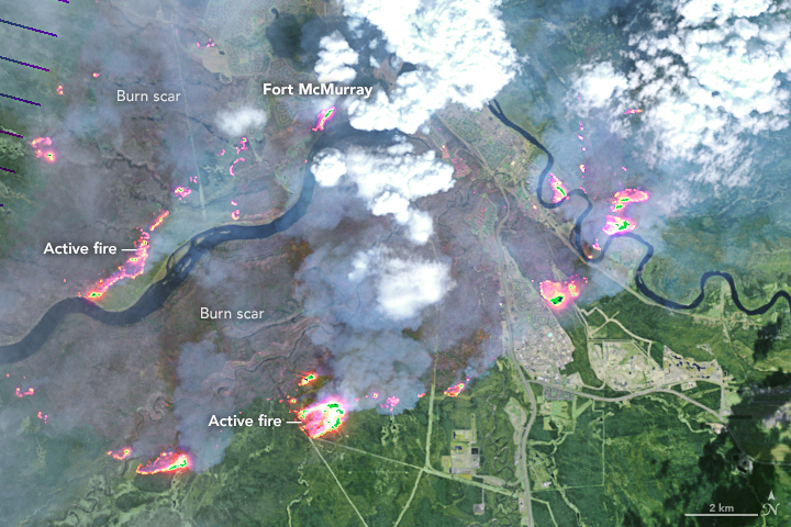
Acquired May 4
References
- Alberta Agriculture and Forestry (2016, May 4) Fort McMurray Area Update. Accessed May 4, 2016.
- Alberta Government (2016, May 4) Emergency updates. Accessed May 4, 2016.
- Regional Municipality of Wood Buffalo (2016, May 4) Fort McMurray Wildfire Updates. Accessed May 4, 2016.
- The Washington Post (2016, May 4) A Canadian oil-sands town is on fire; 80,000 residents must evacuate. Accessed May 4, 2016.
NASA Earth Observatory image by Joshua Stevens, using Landsat data from the U.S. Geological Survey. Caption by Kathryn Hansen.
- Instrument(s):
- Landsat 8 – OLI
Elizabethkingia anophelis
Friday, May 6th, 2016Wisconsin 2016 Elizabethkingia anophelis outbreak
The Wisconsin Department of Health Services (DHS), Division of Public Health (DPH) is currently investigating an outbreak of bacterial infections caused by Elizabethkingia anophelis.
The majority of patients acquiring these infections are over 65 years old, and all patients have a history of at least one underlying serious illness.
The Department quickly identified effective antibiotic treatment for Elizabethkingia, and has alerted health care providers, infection preventionists and laboratories statewide. Since the initial guidance was sent on January 15, there has been a rapid identification of cases and healthcare providers have been able to treat and improve outcomes for patients. DHS continues to provide updates of outbreak-related information that includes laboratory testing, infection control and treatment guidance.
At this time, the source of these infections is still unknown, and the Department continues to work diligently to control this outbreak. Disease detectives from the Department and the Centers for Disease Control and Prevention (CDC) are conducting a comprehensive investigation which includes:
- Interviewing patients with Elizabethkingia anophelis infection and/or their families to gather information about activities and exposures related to healthcare products, food, water, restaurants, and other community settings.
- Obtaining environmental and product samples from facilities that have treated patients with Elizabethkingia anophelis infections. To date, these samples have tested negative and there is no indication the bacteria was spread by a single healthcare facility.
- Conducting a review of medical records.
- Obtaining nose and throat swabs from individuals receiving care on the same units in health care facilities as a patient with a confirmed Elizabethkingia anophelis to determine if they are carrying the bacteria. To date, all of these specimens tested negative, which suggests the bacteria is not spreading from person to person in healthcare settings.
- Obtaining nose and throat swabs from household contacts of patients with confirmed cases to identify if there may have been exposure in their household environment.
- Performing a “social network” analysis to examine any commonalities shared between patients including healthcare facilities or shared locations or activities in the community.
| Type of Cases | Number of Cases |
|---|---|
| Confirmed | 60 |
| Under investigation | 0 |
| Possible cases** | 4 |
| Total cases reported to Wisconsin DPH | 64 |
Affected counties include Columbia, Dane, Dodge, Fond du Lac, Jefferson, Milwaukee, Ozaukee, Racine, Sheboygan, Washington, Waukesha and Winnebago.
There have been 18 deaths among individuals with confirmed Elizabethkingia anophelis infections and an additional 1 death among possible cases for a total of 19 deaths. It has not been determined if these deaths were caused by the infection or other serious pre-existing health problems. Counties where these deaths occurred are: Columbia, Dodge, Fond du lac, Milwaukee, Ozaukee, Racine, Sheboygan, Washington and Waukesha.
*This investigation is ongoing. Case counts may change as additional illnesses are identified and more cases are laboratory confirmed.
**These are cases that tested positive for Elizabethkingia, but will never be confirmed as the same strain of Elizabethkingia anophelis because the outbreak specimens are no longer available to test.


