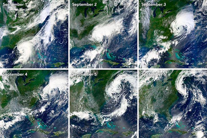
The evolution of Hermine
September 11th, 2016
It is common for Atlantic hurricanes to transition into a completely different class of storm—an extratropical cyclone—as they push north. What is less common is for them to do what Hermine did—linger for several days just off the Eastern Seaboard as an extratropical storm.
This kept Hermine within striking distance of several major cities in the Mid-Atlantic and New England. Unlike Sandy in 2012 (another hurricane that transitioned into an extratropical cyclone), Hermine ultimately stayed just far enough offshore to avoid causing major damage in the Northeast, but the lingering storm churned up surf and produced riptides strong enough to spoil plenty of Labor Day beach plans.
As Hermine fitfully moved up the Atlantic Coast over the course of a week, several Earth-observing satellites kept an eye on the evolving storm. This montage—which is made up of natural-color images captured by sensors on the Aqua, Terra, and Suomi NPP satellites—depicts the storm’s transition from a tropical cyclone to an extratropical cyclone. The names sound similar, but there are fundamental differences between the two types of storms.
As Hermine was approaching Florida on September 1, the tropical cyclone had what severe-weather meteorologist Jeff Halverson described in The Washington Post as “glorious, pinwheel-like symmetry.” At this point, the storm was drawing its energy from warm ocean waters and the release of energy associated with the strong thunderstorms at its core.
By September 3, Hermine had passed over Georgia and South Carolina and was back over the Atlantic Ocean. But due to increasing interaction with weather systems moving east across the Mid-Atlantic region, it had transformed into an extratropical cyclone. While the difference is subtle, notice how the shape of the cloud field became larger and less symmetrical—a clue that the storm had begun drawing energy from the atmosphere—where there was a sharp contrast between warm and cool air masses—rather than warm ocean waters. Like other extratropical storms, Hermine’s strongest winds and rain were to the north and east of the storm’s center. This kept most of the worst weather offshore.

By September 6, extratropical Hermine was still lingering over relatively cool waters southeast of Long Island. With top winds of about 60 miles (100 kilometers) per hour, the storm was creating storm surges of about 1-2 feet (0.3 to 0.6 meters), but the amount of rainfall dwindled as the supply of energy from atmospheric dynamics (contrasts between warm and cool air) fizzled.
The second image was captured by the Moderate Resolution Imaging Spectroradiometer (MODIS) on the Terra satellite on September 7, 2016. By this time, the storm had weakened considerably, but the clouds retained a circular pattern.
-
References
- Hurricanes Science (2016) Demise of a Hurricane. Accessed September 8, 2016.
- The Washington Post (2016, September 6) How Hermine was part hurricane, part nor’easter. Accessed September 8, 2016.
- Weather Underground (2016, September 6) Tropical, subtropical, extratropical? Accessed September 8, 2016.
NASA Earth Observatory images by Joshua Stevens and Jeff Schmaltz, using MODIS data from LANCE/EOSDIS Rapid Response and VIIRS data from the Suomi National Polar-orbiting Partnership. Suomi NPP is the result of a partnership between NASA, the National Oceanic and Atmospheric Administration, and the Department of Defense. Caption by Adam Voiland.
- Instrument(s):
- Terra – MODIS
- Aqua – MODIS
- Suomi NPP – VIIRS

