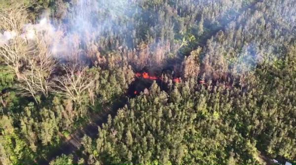
The Kilauea Volcano on Hawaii’s Big Island erupted May 4 and nearby residents were ordered to evacuate.
May 4th, 2018HAWAIIAN VOLCANO OBSERVATORY STATUS REPORT
U.S. Geological Survey
Thursday, May 3, 2018, 10:13 PM HST (Friday, May 4, 2018, 08:13 UTC)
KILAUEA VOLCANO (VNUM #332010)
19°25’16” N 155°17’13” W, Summit Elevation 4091 ft (1247 m)
Current Volcano Alert Level: WARNING
Current Aviation Color Code: ORANGE
The eruption in the Leilani Estates subdivision in the lower East Rift Zone of Kīlauea Volcano that began in late afternoon ended by about 6:30 p.m. HST. Lava spatter and gas bursts erupted from the fissure for about two hours, and lava spread a short distance from the fissure, less than about 10 m (33 ft).
At this time, the fissure is not erupting lava and no other fissures have erupted.
HVO geologists are working near the fissure overnight to track additional activity that may occur, and other scientists are closely tracking the volcano’s overall activity.
 USGS
USGS
Recent Observations
Geologists reported this evening that the presence of sulfur gas is quite noticeable around the fissure, typical of active and recently active fissures. The concentration of sulfur dioxide gas is high within tens of meters (yards) of the fissure.
Lava flows did not advance more than about 10 m (33 ft) from the fissure. The flows are no longer active.
At this time, no other fissures have erupted from along the rift zone.
Tiltmeters at Kīlauea’s summit continue to record deflationary tilt and the lava lake level has dropped about 37 m (121 ft) in the past 24 hours.
Seismic activity has not changed significantly during the day or since the brief fissure eruption.
Hazard Analysis
The opening phases of fissure eruptions are dynamic and uncertain. Additional erupting fissures and new lava outbreaks may occur. It is not possible at this time to say when and where new vents may occur.
Areas downslope of an erupting fissure or vent are at risk of lava inundation. At this time, the general area of the Leilani subdivision appears at greatest risk.
See the Hawaii County Civil Defense messages and alerts for additional information (http://www.hawaiicounty.gov/active-alerts).
HVO Contact Information: askHVO@usgs.gov
MORE INFORMATION
Activity Summary also available by phone: (808) 967-8862
Lava viewing information:
Hawai’i Volcanoes National Park: https://www.nps.gov/havo/planyourvisit/lava2.htm
County of Hawaii: http://www.hawaiicounty.gov/lava-viewing/
Kalapana lava-viewing area: 808-430-1966
Subscribe to these messages: https://volcanoes.usgs.gov/vns2/
Webcam images: https://volcanoes.usgs.gov/volcanoes/kilauea/multimedia_webcams.html
Photos/Video: https://volcanoes.usgs.gov/volcanoes/kilauea/multimedia_chronology.html
Lava Flow Maps: https://volcanoes.usgs.gov/volcanoes/kilauea/multimedia_maps.html
Definitions of terms used in update: https://volcanoes.usgs.gov/volcanoes/kilauea/extra/definitions.pdf
Overview of Kīlauea summit (Halemaʻumaʻu) and East Rift Zone (Puʻu ʻŌʻō ) eruptions:
https://volcanoes.usgs.gov/volcanoes/kilauea/extra/background.pdf
Summary of volcanic hazards from Kīlauea eruptions:
https://volcanoes.usgs.gov/volcanoes/kilauea/extra/hazards.pdf
Recent Earthquakes in Hawai’i (map and list):
https://volcanoes.usgs.gov/hvo/earthquakes/
Explanation of Volcano Alert Levels and Aviation Color Codes:
https://volcanoes.usgs.gov/activity/alertsystem/index.php
https://pubs.usgs.gov/fs/2006/3139/
HVO Contact: askHVO@usgs.gov
CONTACT INFORMATION:
askHVO@usgs.gov
The Hawaiian Volcano Observatory is one of five volcano observatories within the U.S. Geological Survey and is responsible for monitoring volcanoes and earthquakes in Hawai`i.


