Global & Disaster Medicine

Archive for June, 2018

1 dead and dozens are missing from a ferry that sank on Indonesia’s Lake Toba.

CBS


Kenya’s Rift Valley fever outbreak: 26 human cases have been reported and 6 deaths

WHO

On 8 June 2018, the Ministry of Health (MoH) for Kenya confirmed an outbreak of Rift Valley fever. The first patient was admitted to a hospital in Wajir County in north-eastern Kenya on 2 June with fever, body weakness, and bleeding from the gums and mouth. The patient reported having consumed meat from a sick animal; the patient died the same day. On 4 June, two relatives of the index patient were admitted. Blood samples were collected and sent to the Kenya Medical Research Institute, one of which was confirmed positive for Rift Valley fever on 6 June. As of 16 June, a total of 26 human cases have been reported from Wajir (24 cases) and Marsabit (2 cases) counties, including seven confirmed cases and six deaths (case fatality ratio (CFR) = 23%); six patients have been discharged while one is still hospitalized. A high number of deaths and abortions among livestock, including camels and goats, has been reported in Garissa, Kadjiado, Kitui, Marsabit, Tana River, and Wajir counties. People living in these counties were reportedly consuming meat from dead and sick animals.

Public Health Response

Preparedness activities for Rift Valley fever have been ongoing since February 2018 in reaction to the heavy rains and flooding in Kenya. An alert was issued to all County Directors in February 2018 and a general national alert was communicated in May 2018.

The following actions have been taken since the outbreak was confirmed:

  • On 8 June, the MoH and Ministry of Agriculture convened an emergency meeting with the Ministry of Livestock (MoL) and key stakeholders. A health sector task force meeting was held, and partners pledged their support to Rift Valley fever control.
  • On 14 June, the MoH activated the Emergency Operations Centre, with an Event Manager and supporting technical team.
  • On 14 June, a multi-sectoral investigation teams has been deloyed in Wajir County to support the county health teams. Another team will soon be dispatched to support the Marsabit County team.
  • As part of ongoing preparedness activities, active surveillance for Rift Valley fever is being strengthened in affected and at-risk counties, as well as contact tracing in Wajir and Marsabit counties. In Wajir County, five treatment centres have been established.
  • Active case searching and community sensitization activities are ongoing in the affected areas. Guidelines for vector control and other informational materials have been dispatched to Wajir County, and messages are being disseminated through Community Health Volunteers.
  • A ban on slaughtering animals and restriction of livestock movement has been imposed in the affected areas.

WHO risk assessment

Outbreaks of Rift Valley fever are not uncommon in Kenya. The last documented outbreak occurred from November 2014 through January 2015 in north-eastern Kenya; in 2006, a large outbreak killed more than 150 people. The CFR has varied widely in documented outbreaks but the overall CFR tends to be less than 1%.

Kenya’s prior experience with responding to Rift Valley fever outbreaks combined with the preparedness activities undertaken over the preceding months is of benefit. However, the high number of reported deaths and abortions in livestock is concerning, especially because the event affects nomadic communities for which diet is predominantly based on animal products. The high volume of movement of cattle and people in this area increases the risk of further spread of the outbreak both within Kenya, and to neighbouring countries.

WHO advice

Rift Valley fever is a mosquito-borne viral zoonosis that primarily affects animals but also has the capacity to infect humans. The majority of human infections result from direct or indirect contact with the blood or organs of infected animals. Herders, farmers, slaughterhouse workers and veterinarians have an increased risk of infection. Awareness of the risk factors of Rift Valley fever infection and measures to prevent mosquito bites is the only way to reduce human infection and deaths. Public health messages for risk reduction should focus on:

  • Reducing the risk of animal-to-human transmission resulting from unsafe animal husbandry and slaughtering practices. Practicing hand hygiene and wearing gloves and other personal protective equipment when handling sick animals or their tissues or when slaughtering animals is recommended.
  • Reducing the risk of animal-to-human transmission arising from the unsafe consumption of raw or unpasteurized milk or animal tissue. In endemic regions, all animal products should be thoroughly cooked before eating.
  • Reducing the risk of mosquito bites through the implementation of vector control activities (e.g. insecticide spraying and using larvicide to reduce mosquito breeding sites), use of insecticide-impregnated mosquito nets and repellents, and wearing light coloured clothing (long-sleeved shirts and trousers).
  • Restricting or banning the movement of livestock to reduce spread of the virus from infected to uninfected areas.
  • Routine animal vaccination is recommended to prevent Rift Valley fever outbreaks. Vaccination campaigns are not recommended during an outbreak as they may intensify transmission among the herd through needle propagation of the virus. Outbreaks of Rift Valley fever in animals precede human cases, thus the establishment of an active animal health surveillance system is essential to providing early warning for veterinary and public health authorities.

WHO advises against the application of any travel or trade restrictions to the Kenya based on the current information available on this event.

For more information on Rift Valley fever, please see the link below:


Clusters of MERS-CoV in Saudi Arabia

WHO

Between 12 January through 31 May 2018, the National IHR Focal Point of The Kingdom of Saudi Arabia reported 75 laboratory confirmed cases of Middle East respiratory syndrome coronavirus (MERS_CoV), including twenty-three (23) deaths.

Details of the cases

Among these 75 cases, 21 cases were part of four distinct clusters (2 health care and 2 household clusters). The details of these clusters are described below, followed by a table listing all 75 laboratory confirmed cases reported to WHO during this time period:

  • Cluster 1: From 2 through 4 February, a private hospital in Hafer Albatin Region reported a cluster of three (3) health care workers in addition to the suspected index case (four [4] cases in total).
  • Cluster 2: From 25 February through 7 March, a hospital in Riyadh reported six (6) cases, including the suspected index. No health care workers were infected.
  • Cluster 3: From 8 through 24 March, a household cluster of 3 cases (index case and 2 secondary cases) was reported in Jeddah. No health care workers were infected.
  • Cluster 4: From 23 through 31 May, a household cluster was reported from Najran region with eight cases including the suspected index case. This cluster is still under investigation at the time of writing. As of 31 May, no health care workers have been infected and the source of infection is believed to be camels at the initial patient’s home.

As of 31 May, the total global number of laboratory-confirmed cases of MERS-CoV reported since 2012 is 2,220, including 1,844 cases that have been reported from the Kingdom of Saudi Arabia. Among these cases, 790 MERS-CoV associated deaths have occurred since September 2012.

The global number reflects the total number of laboratory-confirmed cases reported to WHO under IHR to date. The total number of deaths includes the deaths that WHO is aware of to date through follow-up with affected member states.

WHO risk assessment

Infection with MERS-CoV can cause severe disease resulting in high mortality. Humans are infected with MERS-CoV from direct or indirect contact with dromedary camels. MERS-CoV has demonstrated the ability to transmit between humans. So far, the observed non-sustained human-to-human transmission has occurred mainly in health care settings.

The notification of additional cases does not change the overall risk assessment. WHO expects that additional cases of MERS-CoV infection will be reported from the Middle East, and that cases will continue to be exported to other countries by individuals who might acquire the infection after exposure to animals or animal products (for example, following contact with dromedaries) or human source (for example, in a health care setting). WHO continues to monitor the epidemiological situation and conducts risk assessment based on the latest available information.

WHO advice

Based on the current situation and available information, WHO encourages all Member States to continue their surveillance for acute respiratory infections and to carefully review any unusual patterns.

Infection prevention and control measures are critical to prevent the possible spread of MERS-CoV in health care facilities. It is not always possible to identify patients with MERS-CoV early because, like other respiratory infections, the early symptoms of MERS-CoV are non-specific. Therefore, health care workers should always apply standard precautions consistently with all patients, regardless of their diagnosis. Droplet precautions should be added to the standard precautions when providing care to patients with symptoms of acute respiratory infection; contact precautions and eye protection should be added when caring for probable or confirmed cases of MERS-CoV infection; airborne precautions should be applied when performing aerosol generating procedures.

Community and household awareness of MERS and MERS prevention measures in the home may reduce household transmission and prevent community clusters.

Until more is understood about MERS-CoV, people with diabetes, renal failure, chronic lung disease, and immunocompromised persons are considered to be at high risk of severe disease from MERS-CoV infection. Therefore, in addition to avoiding close contact with suspected or confirmed human cases of the disease, people with these conditions should avoid close contact with animals, particularly camels, when visiting farms, markets, or barn areas where the virus is known to be or potentially circulating. General hygiene measures, such as regular hand washing before and after touching animals and avoiding contact with sick animals, should be adhered to.

Food hygiene practices should be observed. People should avoid drinking raw camel milk or camel urine, or eating meat that has not been properly cooked.

WHO does not advise special screening at points of entry with regard to this event nor does it currently recommend the application of any travel or trade restrictions.


Ebola and the bush meat trade

CTV

“…….For 25 years, Patrick Matondo has earned a living buying and selling monkeys, bats and other animals popularly known as bush meat along the Congo River. Standing on the riverbank in Mbandaka, a city affected by the deadly new outbreak of the Ebola virus, the father of five said that for the first time he’s worried he won’t be able to support his family.

“Since Ebola was declared, business has decreased by almost half. It’s really, really bad,” the 47-year-old said, hanging his head…..”


The 5.3M earthquake Osaka during morning rush hour Monday, killing at least 4 and injuring 214

CNN


The number of people with jaundice symptoms in Thalakkulathur grama panchayat is up to 84 as the Health Department suspects that the “welcome drink” served at a private party had led to the outbreak

The Hindu

“……Sources in the department said adulterated ice blocks were reportedly used while mixing the drink. Many of the ice factories are unaware of the hygienic practices to be followed while making ice blocks….”


Kilauea: Current Situation (USGS HVO Status Report, June 18)

Current Situation (USGS HVO Status Report, June 18)

Lower East Rift Zone: Lava from Fissure 8 is flowing to the ocean, but could break out of channels and threaten the community of Nanawale (675 homes, pop. 1,384).

Ocean entry remained fairly broad with laze blown onshore. Lightweight volcanic glass continues to fall downwind; high winds may waft lighter particles to greater distances. Summit: Seismicity continues to increase, with a series of M5+ earthquakes likely caused by explosive volcanic activity over the last 48 hours.  Sulfur dioxide emissions are lower than they have been, but remain at dangerous levels.

Impacts (DR-4366-HI SITREP, June 16)

• Injuries / Fatalities: 4 injuries / 0 fatalities (NC since May 22)

• Evacuations (Residents): 2,800 (mandatory), 150 (voluntary) (NC since June 3) • Shelters: 3 open / 114 (-6) occupants (ARC Midnight Shelter Count, June 18)

• Damage: 455 (+135) structures destroyed (192 homes)

• Power: 935 (-79) customers without power

• Transportation: 474 (-1) structures isolated by lava flows

Kīlauea Eruption – Hawai’i County, HI
Alert Level: WARNING Color Code: RED

State / Local Response

• HI EOC at Partial Activation

FEMA Response

• IA approved on June 14; DRC opened on June 15

• Region IX RWC at Steady State


A strong earthquake hit the Japanese city of Osaka during morning rush hour Monday, killing at least three people and injuring 214

Magnitude Mw 5.6
Region NEAR S. COAST OF WESTERN HONSHU
Date time 2018-06-17 22:58:34.4 UTC
Location 34.84 N ; 135.53 E
Depth 14 km
Distances 16 km N of Ōsaka-shi, Japan / pop: 2,593,000 / local time: 07:58:34.4 2018-06-18
4 km NW of Ibaraki, Japan / pop: 274,000 / local time: 07:58:34.4 2018-06-18
Global view

Source parameters reviewed by a seismologist

Seismotectonics of Japan and Vicinity

The North America plate, Pacific plate, Philippine Sea plate, and Eurasia plate all influence the tectonic setting of Japan, Taiwan, and the surrounding area. Some authors divide the edges of these plates into several microplates that together take up the overall relative motions between the larger tectonic blocks, including the Okhotsk microplate in northern Japan, the Okinawa microplate in southern Japan, the Yangzee microplate in the area of the East China Sea, and the Amur microplate in the area of the Sea of Japan.

The seafloor expression of the boundary between the Pacific and North America plates lies 300 km off the east coasts of Hokkaido and Honshu at the Kuril-Kamchatka and Japan trenches. The subduction of the Pacific plate beneath the North America plate, at rates of 83-90 mm/yr, generates abundant seismicity, predominantly as a result of interplate slip along the interface between the plates. The 1958 M 8.4 Etorofu, 1963 M 8.6 Kuril, 2003 M 8.3 Tokachi-Oki, and the 2011 M 9.0 Tohoku earthquakes all exemplify such megathrust seismicity. The 1933 M 8.4 Sanriku-Oki earthquake and the 1994 M 8.3 Shikotan earthquake are examples of intraplate seismicity, caused by deformation within the lithosphere of the subducting Pacific plate (Sanriku-Oki) and of the overriding North America plate (Shikotan), respectively.

At the southern terminus of the Japan Trench the intersection of the Pacific, North America, and Philippine Sea plates forms the Boso Triple Junction, the only example of a trench-trench-trench intersection in the world. South of the triple junction the Pacific plate subducts beneath the Philippine Sea plate at the Izu-Ogasawara trench, at rates of 45-56 mm/yr. This margin is noteworthy because of the steep dip of the subducting Pacific plate (70° or greater below depths of 50 km depth), and because of its heterogeneous seismicity; few earthquakes above M 7 occur at shallow depths, yet many occur below 400 km. The lack of large shallow megathrust earthquakes may be a result of weak coupling at the plate interface, or simply a reflection of an incomplete earthquake catalog with respect to the length of typical seismic cycles.

The northernmost section of the Philippine Sea plate shares a 350 km boundary with the North America plate that runs approximately east-west from the Boso Triple Junction towards the Izu Peninsula. This short boundary is dominated by the subduction of the Philippine Sea plate beneath Japan along the Sagami Trough, but also includes small sections of transform motion.

The subduction of the Philippine Sea plate under the Eurasia plate begins at the Suruga Trough, immediately southwest of the Izu peninsula. In the northern Tōkai, Tonankai and Nankai sections of this subduction zone, historical data indicate M 8+ earthquake recurrence intervals of 100-150 years. The Tonankai and Nankai sections last ruptured in M 8.1 earthquakes in 1944 and 1946, respectively, while the Tōkai section last broke in 1854. In the 1980’s studies began to forecast the imminence of a large earthquake in the Tōkai region, and warned of its potential impact on the cities of Tokyo and Yokohama (the two largest cities in Japan); to date, the expected event has not occurred.

The boundary between the Philippine Sea and Eurasia plates continues south and southwestwards from the Suruga Trough, extending 2000 km along the Nankai and Ryukyu trenches before reaching the island of Taiwan. Along the Ryukyu Trench, the Philippine Sea plate exhibits trench normal subduction at rates increasing from 48 mm/yr in the northeast to 65 mm/yr in the southwest. Convergence and the associated back-arc deformation west of the oceanic trench creates the Ryukyu Islands and the Okinawa Trough. The largest historic event observed along this subduction zone was the M 8.1 Kikai Island earthquake in 1911.

In the vicinity of Taiwan the structure of the Philippine Sea: Eurasia plate boundary and the associated pattern of seismicity becomes more complex. 400 km east of Taiwan a clockwise rotation in the trend of the margin (from NE-SW to E-W), paired with an increase in subduction obliquity creates a section of the plate boundary that exhibits dextral transform and oblique thrusting motions. South of Taiwan the polarity of subduction flips; the Eurasia plate subducts beneath the Philippine Sea plate. Debate surrounds contrasting models of the plate boundary position between the zones of oppositely verging subduction, and the boundary’s relation to patterns of seismicity. Many studies propose that crustal thickening causes the majority of regional seismicity, while others attribute seismicity to deformation associated with subduction. Another resolution proposes a tear in the Philippine Sea plate and a complex assortment of subduction, transform, and collisional motion. All the models concede that seismicity around the island of Taiwan is anomalously shallow, with few earthquakes deeper than 70km.

While there are no instances of an earthquake M>8 in the modern record, Taiwan and its surrounding region have experienced eight M>7.5 events between 1900 and 2014. The dominance of shallow M<8 earthquakes suggests fairly weak plate boundary coupling, with most earthquakes caused by internal plate deformation. The 1935 M 7.1 Hsinchu-Taichung earthquake and the 1999 M 7.6 Chi-Chi Earthquake both exemplify the shallow continental crust thrust faulting that dominates regional seismicity across the island. A major tectonic feature of the island is the Longitudinal Valley Fault, which ruptures frequently in small, shallow earthquakes. In 1951, the Longitudinal Valley Fault hosted twelve M≥6 events known as the Hualien-Taitung earthquake sequence.

Large earthquakes in the vicinity of Japan and Taiwan have been both destructive and deadly. The regions high population density makes shallow earthquakes especially dangerous. Since 1900 there have been 13 earthquakes (9 in Japan, 4 in Taiwan) that have each caused over 1000 fatalities, leading to a total of nearly 200,000 earthquake related deaths. In January 1995 an earthquake that ruptured a southern branch of the Japan Median Tectonic Line near the city of Kobe (population 1.5 million) killed over 5000 people. The 1923 Kanto earthquake shook both Yokohama (population 500,000, at that time) and Tokyo (population 2.1 million), killing 142,000 people. The earthquake also started fires that burned down 90% of the buildings in Yokohama and 40% of the buildings in Tokyo. Most recently, the M9.0 Tohoku earthquake, which ruptured a 400 km stretch of the subduction zone plate boundary east of Honshu, and the tsunami it generated caused over 20,000 fatalities.

More information on regional seismicity and tectonics


ISIS kills at least 26 from Taliban and Afghan armed forces in the city of Nangarhar after carrying out a car bomb attack on Saturday whilst soldiers and militants celebrated an Eid ceasefire.

UK Express


San Francisco: Experts consider these buildings vulnerable to collapse only in extreme shaking caused by rare and powerful earthquakes, similar to the one that struck San Francisco in 1906.

NY Times

USGS document:  HayWired

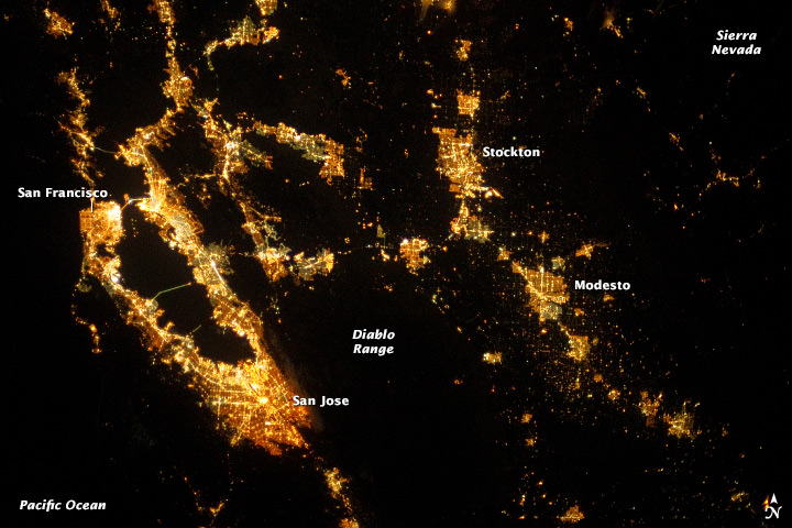
San Francisco Region at Night

Abstract

The HayWired Earthquake Scenario—Engineering Implications is the second volume of U.S. Geological Survey (USGS) Scientific Investigations Report 2017–5013, which describes the HayWired scenario, developed by USGS and its partners. The scenario is a hypothetical yet scientifically realistic earthquake sequence that is being used to better understand hazards for the San Francisco Bay region during and after a magnitude-7 earthquake (mainshock) on the Hayward Fault and its aftershocks.

Analyses in this volume suggest that (1) 800 deaths and 16,000 nonfatal injuries result from shaking alone, plus property and direct business interruption losses of more than $82 billion from shaking, liquefaction, and landslides; (2) the building code is designed to protect lives, but even if all buildings in the region complied with current building codes, 0.4 percent could collapse, 5 percent could be unsafe to occupy, and 19 percent could have restricted use; (3) people expect, prefer, and would be willing to pay for greater resilience of buildings; (4) more than 22,000 people could require extrication from stalled elevators, and more than 2,400 people could require rescue from collapsed buildings; (5) the average east-bay resident could lose water service for 6 weeks, some for as long as 6 months; (6) older steel-frame high-rise office buildings and new reinforced-concrete residential buildings in downtown San Francisco and Oakland could be unusable for as long as 10 months; (7) about 450 large fires could result in a loss of residential and commercial building floor area equivalent to more than 52,000 single-family homes and cause property (building and content) losses approaching $30 billion; and (8) combining earthquake early warning (ShakeAlert) with “drop, cover, and hold on” actions could prevent as many as 1,500 nonfatal injuries out of 18,000 total estimated nonfatal injuries from shaking and liquefaction hazards.

Suggested Citation

Detweiler, S.T., and Wein, A.M., eds., 2018, The HayWired earthquake scenario—Engineering implications: U.S. Geological Survey Scientific Investigations Report 2017–5013–I–Q, 429 p., https://doi.org/10.3133/sir20175013v2.

“……Engineers have known about a major defect in certain steel-frame buildings since 1994, when shaking from the Northridge earthquake in Los Angeles fractured critical joints in more than 60 buildings, bringing at least one very close to collapse. The building code was rewritten to eliminate the flawed technique.….”

1. Hartford Building, 650 California

2. Beal Bank Building, 180 Sansome

3. Bechtel Building, 50 Beale

4. 44 Montgomery

5. 425 California Street

6. 555 California Street

7. McKesson Plaza, One Post

8. Pacific Gas & Electric Building, 77 Beale

9. One Embarcadero Center, 355 Clay

10. Transamerica Pyramid, 600 Montgomery

11. 100 Pine Center, 100 Pine


Categories

Recent Posts

Archives

Admin