Archive for June, 2018
Brazil: From 1 January through 23 May 2018, there were 995 reported cases of measles
Tuesday, June 12th, 2018In Brazil, there is an ongoing measles outbreak. From 1 January through 23 May 2018, there were 995 reported cases (Amazonas State, n=611, and Roraima State n=384). Of these cases, 114 have been laboratory confirmed (30 in Amazonas and 84 in Roraima), including two deaths. Eighty three cases were discarded and 798 remain under investigation.
In Amazonas State, 611 suspected cases were reported from 1 January through 23 May 2018, of which 30 were confirmed1, 63 discarded and 518 are under investigation. In Roraima State, 384 suspected cases were reported, of which 84 were confirmed, 20 discarded and 280 are under investigation2. Of the 84 confirmed cases, 58 are among Venezuelans (69%), 24 Brazilians (28,6%), one from Guiana (1,2%) and 1 Argentinian (1,2%). Of all confirmed cases, 34 are indigenous. Two measles deaths were among Venezuelans from Boa Vista municipality.
The rash onset dates of the confirmed cases in both States were from 4 February through 2 April, 2018. Oswaldo Cruz Foundation (Fiocruz/RJ) conducted an analysis, where they identified the genotype as D8 for all laboratory confirmed cases, which is identical to the 2017 Venezuela outbreak.
Figure 1 shows the progression of the outbreak with a growing upward trend. It is important to consider that there are pending laboratory results for 798 suspected cases under investigation. An exponential increase of confirmed cases could be observed in the coming weeks.
Figure 1. Reported measles cases by rash onset date, Amazonas and Roraima states, Brazil, from 1 January through 12 May, 2018.
Source: Data provided by the Ministry of Health of Brazil and reproduced by PAHO/WHO.
Public health response
Actions implemented include:
- Roraima and Amazonas states have started a vaccination campaign that targets six month old infants through 49-year-old age groups.
- Intensified epidemiological surveillance through active and retrospective institutional case finding, contact tracing, and monitoring of contacts has been implemented.
- Strengthened laboratory network.
- A risk communication strategy has been implemented.
- Training of health care workers in case management.
WHO risk assessment
Measles is a highly contagious viral disease which affects susceptible individuals of all ages and remains a cause of death among young children globally. Measles virus is transmitted via droplets from the nose, mouth, or throat of infected persons. Initial symptoms, which usually appear 10–12 days after infection, include high fever, usually accompanied by one of several of the following: runny nose, bloodshot eyes, cough and tiny white spots on the inside of the mouth. Several days later, a rash develops, starting on the face and upper neck and gradually spreading downwards.
A patient is infectious four days before the start of the rash to four days after the appearance of the rash. There is no specific antiviral treatment for measles, and most people recover within two to three weeks. Case management includes vitamin A administration and antipyretics, and antibiotic and anti-diarrheal medications as needed. Among malnourished children and people with greater susceptibility, measles can cause serious complications, including blindness, encephalitis, severe diarrhea, ear infection, and pneumonia. Measles can be prevented by immunization. In countries with low vaccination coverage, epidemics typically occur every two to three years and usually last between two and three months, although their duration varies according to population size, crowding, and the population’s immunity status.
The Region of the Americas was declared free of measles in September 2016, nevertheless, outbreaks caused by imported cases from other regions may occur sporadically.
The risk of spread at the national level in Brazil remains high due to the epidemiological situation and the high potential of transmission. The main challenges are vaccination coverage among immigrants and laboratory diagnostic capacity in local facilities. Because of ongoing transmission, vaccination strategies and other actions are being implemented to control the outbreak by local and federal authorities in Brazil. At the regional level, the potential impact is considered high given the performance of routine immunization programmes and prevention and control capacities in other countries in the Region.
WHO advice
On 1 September 2017, the Pan American Health Organization / World Health Organization (PAHO/WHO) shared information on this outbreak with its Member States and alerted them regarding the risk of outbreaks occurring from imported measles cases, as well as the possibility of re-introduction of the disease in areas with low vaccination coverage. In light of continuous reports of imported measles cases from other Regions and ongoing outbreaks in the Americas, PAHO/WHO urges all Member States to:
- Vaccinate to maintain coverage of 95% with the first and second doses of measles, mumps, rubella (MMR) vaccine.
- Vaccinate at-risk populations (without proof of vaccination or immunity against measles and rubella), such as health workers, people working in tourism and transportation (hotel and catering, airports, taxi drivers, etc.), and international travelers.
- Maintain a reserve of measles-rubella (MR) vaccine and syringes for control of imported cases in each country in the Region.
- Strengthen epidemiological surveillance of measles for timely detection of all suspected cases of measles in public and private healthcare facilities and ensure that samples are received by laboratories within five days of being taken.
- Provide a rapid response to imported measles cases through the activation of rapid response teams to prevent the re-establishment of endemic transmission. Once a rapid response team has been activated, continued coordination between the national and local levels must be ensured, with permanent and fluid communication channels between all levels (national, sub-national, and local).
For more information, please see the links below:
1Suspected cases were reported in 14 municipalities: Anori, Beruri, Careiro da Várzea, Humaitá, Itacoatiara, Itapiranga, Iranduba, Jutaí, Manacapuru, Manaus, Novo Airão, Parintins, São Gabriel da Cachoeira and Tefé. All cases are brazilians.
2Suspected cases were reported in 11 municipalities: Alto Alegre, Amajarí, Boa vista, Cantá, Caracaraí, Caroebe, Iracema, Pacaraima, Rorainópolis, São João da Baliza and Uiramutã. Of the 384 suspected cases, 10 cases were notified in Brazil, but their residence is in the following Venezuela municipalities: Santa Helena (04), Gran Sabana (03), Ciudad Bolivar (01), Maracaibo (01) and Sifontes (01).
14 more suspected cases have been reported in the Democratic Republic of Congo (DRC) Ebola outbreak
Tuesday, June 12th, 2018Peter Salama: Deputy Director-General for Emergency Preparedness and Response
DRC #Ebola update as of 9 June:
38 confirmed cases
14 probable cases
14 suspected cases
Total: 66 cases, including 28 deaths
New developments:
3 new suspected cases
11 suspected cases from 8 June reported today
12 samples tested negative
1 death in a known confirmed case
FEMA Sit Rep; 6-11-18 re Kilauea
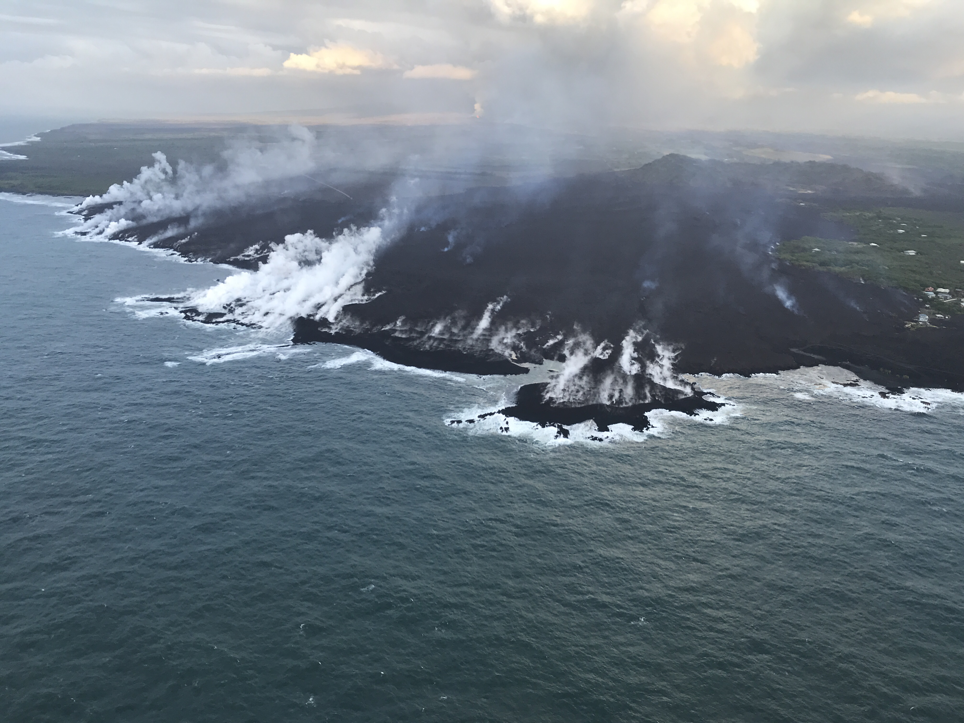
Monday, June 11th, 2018Eruptions continue from the lower East Rift Zone fissure system.
Minor flows overtopping the channel levees have been observed. The ocean entry area continues to produce laze.
Volcanic gas emissions remain high.
Impacts (FEMA-4366-DR-HI COP, 11:00 p.m. EDT June 7)
Injuries / Fatalities: 4 injuries / 0 fatalities
• Evacuations: Mandatory for 2,800 residents; an additional 150 residents under voluntary evacuation in Papaya Farms Road and Waa Waa
• 475 structures isolated but potentially not impacted, due to roads being cut off
• Shelters: 3 shelters open with 131 occupants (ARC Midnight Shelter Count, June 11)
• Damage: 320 structures destroyed (130 homes)
• Power: 856 customers without power; Puna Geothermal Venture plant not accessible except by off-road vehicles and air transport; substation destroyed
• Transportation: FAA Temporary Flight Restrictions extended through August 31 State / Local Response
• HI EOC at Partial Activation; Governor declared a State of Emergency
FEMA Response
• Interim Operating Facility (IOF) established with N-IMAT East 1, a portion of N-IMAT East 2, and Bothell MERS supporting
6/11/1955: a racing car in Le Mans, France, goes out of control and crashes into stands filled with spectators, killing 82
Monday, June 11th, 2018Should “terrorism” be re-defined?
Monday, June 11th, 2018International terrorism: Perpetrated by individuals and/or groups inspired by or associated with designated foreign terrorist organizations or nations (state-sponsored).
–for example, the December 2, 2015 shooting in San Bernardino, CA, that killed 14 people and wounded 22 which involved a married couple who radicalized for some time prior to the attack and were inspired by multiple extremist ideologies and foreign terrorist organizations.
Domestic terrorism: Perpetrated by individuals and/or groups inspired by or associated with primarily U.S.-based movements that espouse extremist ideologies of a political, religious, social, racial, or environmental nature.
–for example, the June 8, 2014 Las Vegas shooting, during which two police officers inside a restaurant were killed in an ambush-style attack, which was committed by a married couple who held anti-government views and who intended to use the shooting to start a revolution.”
USGS summary on Kilauea
Sunday, June 10th, 2018Kīlauea is the youngest and southeastern most volcano on the Island of Hawai‘i. Topographically Kīlauea appears as only a bulge on the southeastern flank of Mauna Loa, and so for many years Kīlauea was thought to be a mere satellite of its giant neighbor, not a separate volcano. However, research over the past few decades shows clearly that Kīlauea has its own magma-plumbing system, extending to the surface from more than 60 km deep in the earth.
In fact, the summit of Kīlauea lies on a curving line of volcanoes that includes Mauna Kea and Kohala and excludes Mauna Loa. In other words, Kīlauea is to Mauna Kea as Lō‘ihi is to Mauna Loa. Hawaiians used the word Kīlauea only for the summit caldera, but earth scientists and, over time, popular usage have extended the name to include the entire volcano.
Kīlauea is the home of Pele, the Hawaiian volcano goddess. Hawaiian chants and oral traditions tell in veiled form of many eruptions fomented by an angry Pele before the first European, the missionary Rev. William Ellis, saw the summit in 1823. The caldera was the site of nearly continuous activity during the 19th century and the early part of the 20th century. Since 1952 there have been 34 eruptions, and since January 1983 eruptive activity has been continuous along the East Rift Zone. In March 2008, a vent also opened in Halema‘uma‘u Crater at the volcano’s summit. The summit crater hosts an active lava pond and a vigorous gas plume. Kīlauea ranks among the world’s most active volcanoes and may even top the list.
ocation: Island of Hawai‘i
Latitude: 19.421° N
Longitude: 155.287° W
Elevation: 1,222 (m) 4,009 (f)
Volcano type: Shield
Composition: Basalt
Most recent eruption: Current
Nearby towns: Volcano, Pāhoa, Kalapana, Mountain View
Threat Potential: Very High *

NASA captures deadly eruption in Guatemala
Sunday, June 10th, 2018
Fuego in Guatemala is one of Central America’s most active volcanoes. For years, the towering Volcán de Fuego has puffed continuously, punctuated by occasional episodes of explosive activity, big ash plumes, lava flows, and avalanche-like debris slides known as pyroclastic flows.
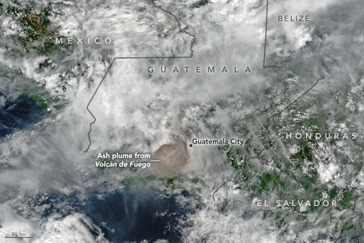
Just before noon on June 3, 2018, the volcano produced an explosive eruption that sent ash billowing thousands of meters into the air. A deadly mixture of ash, rock fragments, and hot gases rushed down ravines and stream channels on the sides of the volcano. Since these pyroclastic flows often move at speeds of greater than 80 kilometers (50 miles) per hour, they easily topple trees, homes, or anything else in their path. According to news reports, more than two dozen people were killed. As a precautionary measure, thousands of other people have been evacuated.
The Visible Infrared Imaging Radiometer Suite (VIIRS) on Suomi NPP acquired this image of the ash plume at 1 p.m. local time (19:00 Universal Time) on June 3, 2018, after the ash (brown) had punched through a deck of clouds. A report from the Washington Volcanic Ash Advisory Center estimated the plume’s maximum height at 15 kilometers (9 miles). Imagery from a geostationary satellite showed winds blowing the plume to the east. The eruption deposited ash on several communities surrounding the volcano, including Guatemala City, which is 70 kilometers (40 miles) to the east.
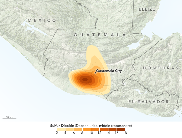
In addition to ash, the plume contains gaseous components invisible to the human eye, including sulfur dioxide (SO2). The gas can affect human health—irritating the nose and throat when breathed in—and reacts with water vapor to produce acid rain. Sulfur dioxide also can react in the atmosphere to form aerosol particles, which can contribute to outbreaks of haze and sometimes cool the climate.
Satellite sensors such as the Atmospheric Infrared Sounder (AIRS) on the Aqua satellite and the Ozone Mapping Profiler Suite (OMPS) on Suomi NPP make frequent observations of sulfur dioxide. The map above shows concentrations of sulfur dioxide in the middle troposphere at an altitude of 8 kilometers (5 miles) as detected by OMPS on June 3.
Upon seeing data collected by AIRS several hours after the eruption that showed high levels of sulfur dioxide in the upper troposphere, Michigan Tech volcanologist Simon Carn tweeted that this appeared to be the “highest sulfur dioxide loading measured in a Fuego eruption in the satellite era.”
-
References
- Discover (2018, June 4) Rocky Planet: Deadliest Eruption of 2018. Accessed June 4, 2018.
- NASA Global Sulfur Dioxide Monitoring Home Page. Accessed June 4, 2018.
- Smithsonian Institution Global Volcanism Program (2018) Fuego. Accessed June 4, 2018.
- The New York Times (2018, June 4) Guatemala’s Fuego Volcano Erupts, Killing at Least 33. Accessed June 4, 2018.
- U.S. Geological Survey Pyroclastic flows move fast and destroy everything in their path. Accessed June 4, 2018.
- Volcano Discovery (2018, June 4) Fuego volcano news & eruption update. Accessed June 4, 2018.
NASA Earth Observatory images by Joshua Stevens, using VIIRS data from the Suomi National Polar-orbiting Partnership and OMPS data from the Goddard Earth Sciences Data and Information Services Center (GES DISC). Story by Adam Voiland.
- Instrument(s):
- Suomi NPP – VIIRS
- Suomi NPP – OMPS


