Archive for September, 2018
The death toll in a suicide bombing among a group of people protesting a local police commander in eastern Afghanistan has risen to 68 with 165 others wounded.
Wednesday, September 12th, 2018GAO: Initial Observations on the Federal Response and Key Recovery Challenges to the Hurricanes and Wildfires of 2017
Wednesday, September 12th, 20182017 Hurricanes and Wildfires:
Initial Observations on the Federal Response and Key Recovery Challenges
GAO-18-472: Published: Sep 4, 2018. Publicly Released: Sep 4, 2018.
Federal and state preparedness and coordination efforts prior to and after the 2017 hurricane and wildfire disasters facilitated the response in Texas, Florida, and California. Specifically, the Federal Emergency Management Agency (FEMA) and state emergency management officials implemented various preparedness actions prior to landfall of the hurricanes and during the wildfires—such as predeploying federal personnel to support response efforts; colocating federal, state, and local emergency managers; and pre-staging and delivery of commodities like food and water. Further, according to FEMA and state officials, preexisting coordination mechanisms and relationships also facilitated response efforts in each state. For example, FEMA and each state had conducted numerous emergency exercises in the years prior to these disasters and had developed relationships during response to prior disasters that led to accelerated decision-making during the 2017 disasters. Federal and state officials emphasized that there were certainly unprecedented challenges during these disasters—such as deploying a sufficient and adequately-trained FEMA disaster workforce—and lessons learned, but prior response coordination efforts helped to quickly and effectively resolve many of these challenges.
The federal government provided significant support to Puerto Rico and the U.S. Virgin Islands in response to Hurricanes Irma and Maria, but faced numerous challenges that complicated response efforts. FEMA efforts in Puerto Rico alone were the largest and longest single response in the agency’s history. As of April 2018, FEMA had obligated over $12 billion for response and recovery for Hurricane Maria (see figure below) reflecting the scale and complexity of efforts given the widespread damage. FEMA tasked federal agencies with over 1,000 response mission assignments for Hurricanes Maria and Irma in the territories at a cost of over $5 billion, compared to about 400 such assignments for Hurricanes Harvey and Irma and the California wildfires combined. For example, FEMA assigned the U.S. Army Corps of Engineers the mission to install over 1,700 emergency electricity generators in Puerto Rico, compared to the 310 for the response to Hurricane Katrina.
Federal Emergency Management Agency Disaster Relief Fund Obligations and Expenditures for Hurricanes Harvey, Irma, Maria, and California Wildfires through April 30, 2018

Note: An obligation is a definite commitment that creates a legal liability of the government for the payment of goods and services ordered or received. An expenditure is an amount paid by federal agencies by cash or cash equivalent, during the fiscal year to liquidate government obligations.
Nevertheless, GAO found that FEMA faced a number of challenges that slowed and complicated its response efforts to Hurricane Maria, particularly in Puerto Rico. Many of these challenges were also highlighted in FEMA’s own 2017 hurricane after action report, including:
- the sequential and overlapping timing of the three hurricanes—with Maria being the last of the three—caused staffing shortages and required FEMA to shift staff to the territories that were already deployed to other disasters;
- logistical challenges complicated efforts to deploy federal resources and personnel quickly given the remote distance of both territories; and
- limited preparedness by the U.S. Virgin Islands and Puerto Rico for a Category 5 hurricane and incapacitation of local response functions due to widespread devastation and loss of power and communications led FEMA to assume response functions that territories would usually perform themselves.
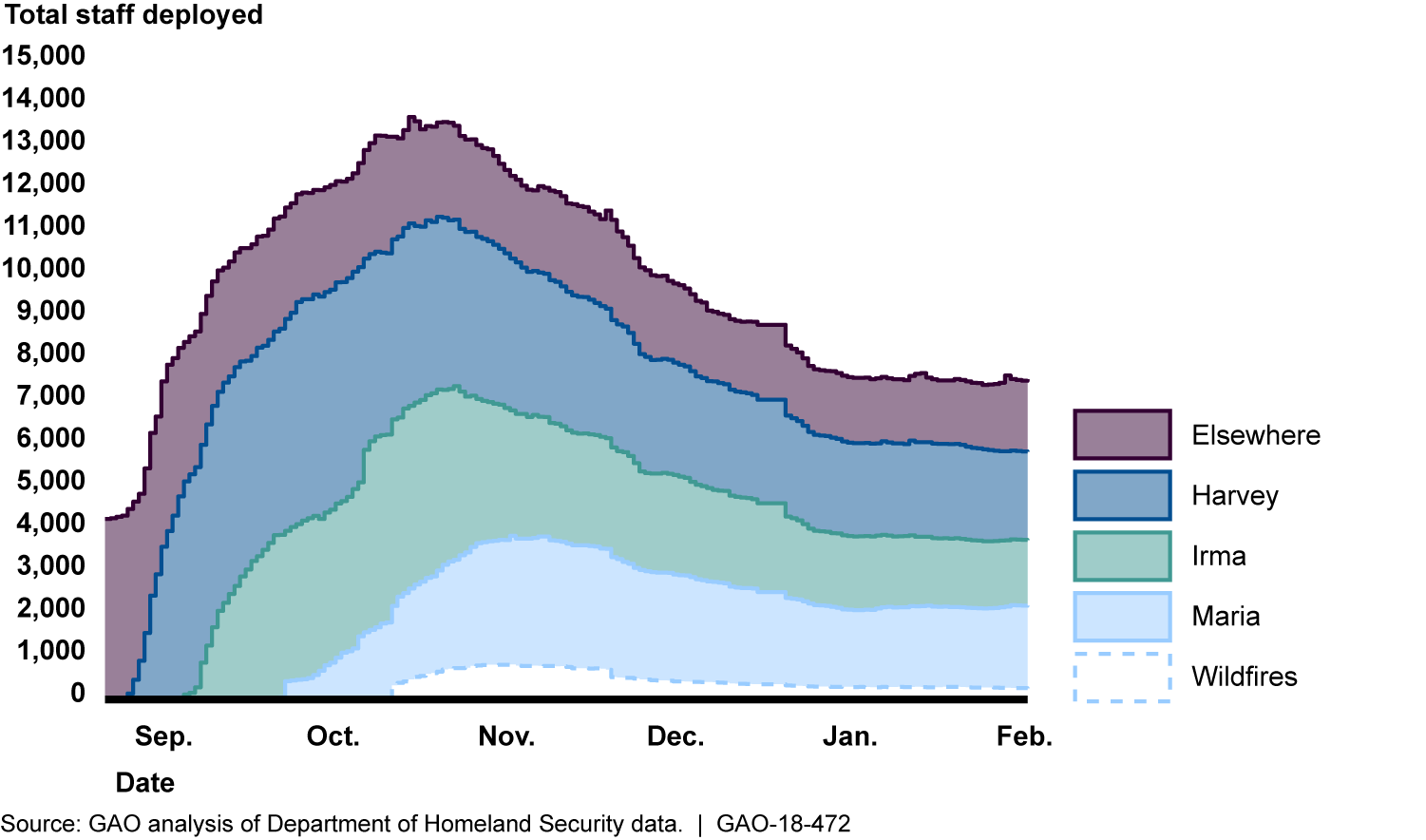
The 2017 hurricanes and wildfires highlighted some longstanding issues and revealed other emerging response and recovery challenges. For example, the concurrent timing and scale of the disaster damages nationwide caused shortages in available debris removal contractors and delays in removing disaster debris—a key first step in recovery. In addition, FEMA’s available workforce was overwhelmed by the response needs. For example, at the height of FEMA workforce deployments in October 2017, 54 percent of staff were serving in a capacity in which they did not hold the title of “Qualified”—according to FEMA’s qualification system standards—a past challenge GAO has identified. FEMA officials noted that staff shortages, and lack of trained personnel with program expertise led to complications in its response efforts, particularly after Hurricane Maria.
Federal Disaster Workforce Deployed at the Height of 2017 Response Acivities

Further, federal, state, and local officials faced challenges finding temporary housing for disaster survivors given the extensive damage to available housing in each location. For example, given the widespread damage in Puerto Rico and lack of hotels and other temporary housing, FEMA transported survivors to the mainland United States to stay in hotels. FEMA also used new authorities and procedures to meet the need, such as providing Texas as much as $1 billion to manage its own housing program. However, this approach had not been used or tested in past disasters and state officials noted challenges in managing the program such as staffing shortfalls. State officials further noted challenges in coordinating with FEMA that led to delays in providing assistance to survivors. GAO will continue to monitor these programs.
Why GAO Did This Study
In 2017, four sequential disasters—hurricanes Harvey, Irma, Maria, and the California wildfires—created an unprecedented demand for federal disaster response and recovery resources. According to FEMA, 2017 included three of the top five costliest hurricanes on record.
The National Oceanic and Atmospheric Administration estimated that the cumulative damages from weather and climate related disasters in the United States were over $300 billion in 2017 alone. As of June 2018, Congress had appropriated over $120 billion in supplemental funding for response and recovery related to the 2017 hurricanes and wildfires. Further, in October 2017, close to 14,000 federal employees were deployed in response to the disasters.
Given the scale and cost of these disasters, Congress and others have raised questions about the federal response and various recovery challenges that have arisen since the disasters. This report provides GAO’s observations on: (1) federal and state preparedness and response coordination for hurricanes Harvey and Irma in Texas and Florida, and the California wildfires; (2) federal preparedness for and response to hurricanes Irma and Maria in Puerto Rico and the U.S. Virgin Islands; and (3) existing and emerging disaster recovery challenges highlighted by these disasters.
GAO analyzed FEMA policies, procedures, guidance, and data specific to disaster response and recovery programs. GAO focused on the busiest period of disaster response activity for the federal government—August 2017 through January 2018, with select updates on recovery efforts and obtained updates through June 2018. In October and November 2017, GAO teams made site visits to hurricane damaged areas in Texas, Florida, Puerto Rico, and the U.S. Virgin Islands. At these locations, GAO visited FEMA joint field operation locations and interviewed FEMA, Department of Defense, and other federal officials about response and recovery operations, visited disaster recovery centers, and observed damage. GAO also interviewed FEMA officials responsible for wildfire response and recovery efforts in California.
Additionally, GAO interviewed state and territorial emergency management officials or their designee in Texas, Florida, California, Puerto Rico, and the U.S. Virgin Islands, as well as officials from eight cities and counties in Texas, Florida, and California (selected based on their proximity to the disaster impacted areas and their availability) to discuss their observations on the federal response in their respective jurisdictions. While the perspectives of these officials are not generalizable, they provided valuable insights into the federal response to the 2017 disasters.
This report includes 10 appendices that provide further details and data on federal response and recovery efforts. These areas cover key issues and challenges that GAO believes are critical for assessing the federal response and warrant continued Congressional and agency oversight during disaster recovery.
GAO is not making recommendations in this report, but has ongoing work that will address various response and recovery programs and challenges in more detail. GAO will make recommendations, as appropriate, once this work is completed.
In commenting on a draft of this report, DHS stated that the report highlighted the challenges of the complicated response and recovery efforts as well as provided insights into these efforts. DHS also noted that it is continuing to apply lessons learned from 2017 to improve its future program delivery and response efforts.
For more information, contact Christopher Currie at (404) 679-1875 or curriec@gao.gov.
Abnormally heavy monsoon rains drenched Southeast Asia, leading to the worst flooding in the state of Kerala since 1924.
Tuesday, September 11th, 2018
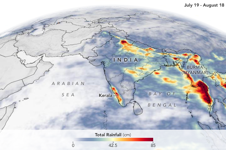
Abnormally heavy monsoon rains drenched Southeast Asia, leading to the worst flooding in the state of Kerala since 1924. The event, which started with rains on August 8, 2018, displaced over a million people, led to hundreds of deaths, damaged over 50,000 houses throughout the region, and severely affected 13 of the 14 districts in Kerala. While it brought the region’s most intense flooding this summer, the rain was one of many high precipitation events in Kerala this monsoon season.
The image shows satellite-based rainfall accumulation from July 19 to August 18, 2018. Rainfall peaked in Kerala on July 20 and again reached abnormally high levels between August 8 and 16. Since the beginning of June, the region received 42 percent more rainfall than normal for this time period. In the first 20 days of August, the region experienced 164 percent more rain than normal.
Intense rainfall events have hit other areas of Southeast Asia as well. Eastern Myanmar experienced torrential downpours in mid-July and August, causing fatalities and displacing 150,000 people in one month. The floods were the worst in 30 years. The Bago and Sittaung rivers swelled to their highest levels in more than five decades, with the Sittaung river 7 feet above danger levels in areas.
The animation above shows rainfall accumulating starting from July 19 to August 18, 2018. Heavy rain started to fall over Myanmar around July 29.
These rainfall data are remotely-sensed estimates that come from the Integrated Multi-Satellite Retrievals (IMERG), a product of the Global Precipitation Measurement (GPM) mission. The GPM satellite is the core of a rainfall observatory that includes measurements from NASA, the Japan Aerospace Exploration Agency, and five other national and international partners. Local rainfall amounts can be significantly higher when measured from the ground.
NASA Earth Observatory images by Joshua Stevens, using IMERG data from the Global Precipitation Mission (GPM) at NASA/GSFC. Story by Kasha Patel.
“……Officials and experts have said the floods in Kerala – which has 44 rivers flowing through it – would not have been so severe if authorities had gradually released water from at least 30 dams…….”
NASA: Tropical cyclones and storms in the Atlantic
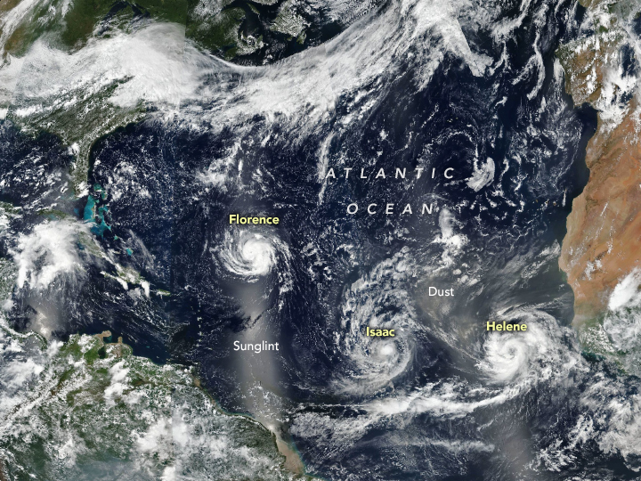
Tuesday, September 11th, 2018The Atlantic basin was relatively quiet for much of August 2018, but September brought a surge in storm activity. On September 9, 2018, Florence, Isaac, and Helene were all churning up the North Atlantic. The trio of storms is visible in this image acquired by the Visible Infrared Imaging Radiometer Suite (VIIRS) on the Suomi NPP satellite.
Category 4 Hurricane Florence was the most ominous for people in the United States. Forecasters at the National Hurricane Center expect the slow-moving storm to reach the coast of the Carolinas on September 12 or 13, bringing a life-threatening storm surge, exceptionally heavy inland rains, and damaging winds. Though weakening, Category 1 Hurricane Isaac is on a path to cross the Lesser Antilles islands and move into the eastern Caribbean Sea on September 13. Category 2 Hurricane Helene was strengthening, but is expected to veer northward into the open ocean.
The bright strips in the image are reflected sunlight, or “glint,” which can show up over ocean areas in the middle of each orbit.
NASA Earth Observatory image by Joshua Stevens, using VIIRS data from the Suomi National Polar-orbiting Partnership. Caption by Adam Voiland.
Florence forecasted to intensify into a major hurricane by Monday night.
Monday, September 10th, 2018- Florence is now intensifying after regaining hurricane strength on Sunday.
- Rapid intensification into a major hurricane is expected by Monday night.
- A strike on the U.S. East Coast is increasingly likely.
- This may happen as soon as Thursday.
- Those near the East Coast should monitor closely and firm up their hurricane plans.
- Florence is generating swells that are affecting parts of the U.S. coastline.
7 ways public health in India has changed over the last decade
Monday, September 10th, 20181. A downtrend in communicable diseases
2. A focus on prevention
3. Reduced neonatal mortality rates
4. Tackling antimicrobial resistance
5. Improved nutrition
6. Using digital health and artificial intelligence for social impact
7. Stronger government accountability

FLORENCE EXPECTED TO BECOME A HURRICANE TODAY
Sunday, September 9th, 2018442
WTNT31 KNHC 090843
TCPAT1
BULLETIN
Tropical Storm Florence Advisory Number 40
NWS National Hurricane Center Miami FL AL062018
500 AM AST Sun Sep 09 2018
…FLORENCE EXPECTED TO BECOME A HURRICANE TODAY…

SUMMARY OF 500 AM AST…0900 UTC…INFORMATION
———————————————-
LOCATION…24.5N 55.8W
ABOUT 765 MI…1235 KM SE OF BERMUDA
ABOUT 640 MI…1030 KM NE OF THE NORTHERN LEEWARD ISLANDS
MAXIMUM SUSTAINED WINDS…70 MPH…110 KM/H
PRESENT MOVEMENT…W OR 270 DEGREES AT 6 MPH…9 KM/H
MINIMUM CENTRAL PRESSURE…989 MB…29.21 INCHES
WATCHES AND WARNINGS
——————–
There are no coastal watches or warnings in effect.
DISCUSSION AND OUTLOOK
———————-
At 500 AM AST (0900 UTC), the center of Tropical Storm Florence was
located near latitude 24.5 North, longitude 55.8 West. Florence is
moving toward the west near 6 mph (9 km/h), and this general motion
is expected to continue today. A west-northwestward motion with an
increase in forward speed is expected by Monday, and that motion is
forecast to continue through mid-week. On the forecast track, the
center of Florence will move over the southwestern Atlantic Ocean
between Bermuda and the Bahamas Tuesday and Wednesday, and approach
the southeastern U.S. coast on Thursday.
Maximum sustained winds are near 70 mph (110 km/h) with higher
gusts. Florence is expected to become a hurricane today and rapid
intensification is likely to begin by tonight. Florence is forecast
to become a major hurricane on Monday.
Tropical-storm-force winds extend outward up to 125 miles (205 km)
from the center.
The estimated minimum central pressure is 989 mb (29.21 inches).
HAZARDS AFFECTING LAND
———————-
SURF: Swells generated by Florence are affecting Bermuda and are
beginning to reach portions of the U.S. East Coast. These swells
are likely to cause life-threatening surf and rip current
conditions. Please consult products from your local weather office.
NEXT ADVISORY
————-
Next complete advisory at 1100 AM AST.
$$
Forecaster Brown
November 18, 2015–June 6, 2016: The largest cholera outbreak (1,797 cases; attack rate 5.1 per 1,000) in the history of Dadaab refugee camp in Kenya occurred.
Sunday, September 9th, 2018Golicha Q, Shetty S, Nasiblov O, et al. Cholera Outbreak in Dadaab Refugee Camp, Kenya — November 2015–June 2016. MMWR Morb Mortal Wkly Rep 2018;67:958–961. DOI: http://dx.doi.org/10.15585/mmwr.mm6734a4.
“…..During November 18, 2015–June 6, 2016, the largest cholera outbreak (1,797 cases; attack rate 5.1 per 1,000) in the history of Dadaab refugee camp in Kenya occurred. Significant risk factors included living in a compound where open defecation, visible human and solid waste, and eating from a shared plate were common. Chlorine levels in water were below standard, and handwashing facilities were insufficient…..”


