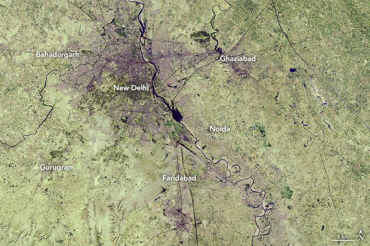
NASA: New Delhi in 1989 and 2018
October 2nd, 2018

The capital of India, New Delhi, has been experiencing one of the fastest urban expansions in the world. Vast areas of croplands and grasslands are being turned into streets, buildings, and parking lots, attracting an unprecedented amount of new residents. By 2050, the United Nations projects India will add 400 million urban dwellers, which would be the largest urban migration in the world for the thirty-two year period.
These images show the growth in the city of New Delhi and its adjacent areas—a territory collectively known as Delhi—from December 5, 1989, (left) to June 5, 2018 (right). These false-color images use a combination of visible and short-wave infrared light to make it easier to distinguish urban areas. The 1989 image was acquired by the Thematic Mapper on Landsat 5 (bands 7,5,3), and the 2018 image was acquired by Operational Land Imager on Landsat 8 (bands 7,6,4).
Most of the expansion in Delhi has occurred on the peripheries of New Delhi, as rural areas have become more urban. The geographic size of Delhi has almost doubled from 1991 to 2011, with the number of urban households doubling while the number of rural houses declined by half. Cities outside of Delhi—Bahadurgarh, Ghaziabad, Noida, Faridabad, and Gurugram—have also experienced urban growth over the past three decades, as shown in these images.
With a flourishing service economy, Delhi is a draw for migrants because it has one of India’s highest per capita incomes. According to the latest census data, most people (and their families) move into the city for work. The Times of India reported that the nation’s capital grew by nearly 1,000 people each day in 2016, of which 300 moved into the city. By 2028, New Delhi is expected to surpass Tokyo as the most populous city in the world.
The increased urbanization has had several consequences. One is that the temperatures of the urban areas are often hotter than surrounding vegetated areas. Manmade structures absorb the heat and then radiate that into the air at night, increasing the local temperature (the urban heat island effect). Research has shown that densely built parts of Delhi can be 7°C (45°F) to 9°C (48°F) warmer in the wintertime than undeveloped regions.
Additionally, sprawling cities can have several environmental consequences, such as increasing traffic congestion, greenhouse gas emissions, and air pollution. From 2005 to 2014, NASA scientists have observed an increase in air pollution in India due to the country’s fast-growing economies and expanding industry.
India is one of many countries with fast-growing cities. By 2050, China is projected to add 250 million people in its urban areas, and Nigeria may add 190 million urban dwellers. In total, India, China and Nigeria are expected to account for 35 percent of the world’s urban population growth between 2018 and 2050.
NASA Earth Observatory images by Lauren Dauphin, using Landsat data from the U.S. Geological Survey. Story by Kasha Patel.

