Archive for October, 2018
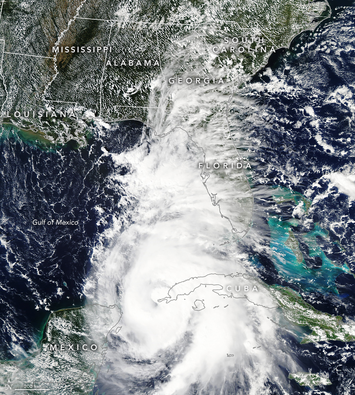
Nat’l Hurricane Center 4AM CDT, 10/10/18 Advisory: Michael Cat. 4
Wednesday, October 10th, 2018Hurricane Michael Advisory Number 15
NWS National Hurricane Center Miami FL AL142018
400 AM CDT Wed Oct 10 2018
…EXTREMELY DANGEROUS CATEGORY 4 MICHAEL STRENGTHENS
FURTHER AS IT HEADS NORTHWARD TOWARD THE FLORIDA PANHANDLE…
…LIFE-THREATENING STORM SURGE…HURRICANE FORCE WINDS…AND HEAVY
RAINFALL EXPECTED ALONG THE NORTHEASTERN GULF COAST…
SUMMARY OF 400 AM CDT…0900 UTC…INFORMATION
———————————————-
LOCATION…28.3N 86.5W
ABOUT 140 MI…225 KM SSW OF PANAMA CITY FLORIDA
ABOUT 130 MI…215 KM SW OF APALACHICOLA FLORIDA
MAXIMUM SUSTAINED WINDS…140 MPH…220 KM/H
PRESENT MOVEMENT…N OR 360 DEGREES AT 13 MPH…20 KM/H
MINIMUM CENTRAL PRESSURE…943 MB…27.85 INCHES
WATCHES AND WARNINGS
——————–
CHANGES WITH THIS ADVISORY:
A Tropical Storm Warning is now in effect from South Santee River,
South Carolina to Surf City, North Carolina.
The Storm Surge Watch has been discontinued west of the
Okaloosa/Walton County Line Florida.
SUMMARY OF WATCHES AND WARNINGS IN EFFECT:
A Storm Surge Warning is in effect for…
* Okaloosa/Walton County Line Florida to Anclote River Florida
A Storm Surge Watch is in effect for…
* Anclote River Florida to Anna Maria Island Florida, including
Tampa Bay
A Hurricane Warning is in effect for…
* Alabama/Florida border to Suwannee River Florida
A Tropical Storm Warning is in effect for…
* Alabama/Florida border to the Mississippi/Alabama border
* Suwanee River Florida to Chassahowitzka Florida
* North of Fernandina Beach Florida to Surf City North Carolina
A Tropical Storm Watch is in effect for…
* Chassahowitzka to Anna Maria Island Florida, including Tampa Bay
* Mississippi/Alabama border to the Mouth of the Pearl River
* Surf City North Carolina to Duck North Carolina
* Pamlico and Albemarle Sounds
A Storm Surge Warning means there is a danger of life-threatening
inundation, from rising water moving inland from the coastline,
during the next 36 hours in the indicated locations. For a depiction
of areas at risk, please see the National Weather Service Storm
Surge Watch/Warning Graphic, available at hurricanes.gov. This is
a life-threatening situation. Persons located within these areas
should take all necessary actions to protect life and property from
rising water and the potential for other dangerous conditions.
Promptly follow evacuation and other instructions from local
officials.
A Hurricane Warning means that hurricane conditions are expected
somewhere within the warning area, in this case within the next
12 hours. Preparations to protect life and property should be
rushed to completion.
A Tropical Storm Warning means that tropical storm conditions are
expected somewhere within the warning area, in this case during the
next 12 hours.
A Storm Surge Watch means there is a possibility of life-
threatening inundation, from rising water moving inland from the
coastline.
A Tropical Storm Watch means that tropical storm conditions are
possible within the watch area.
Interests elsewhere across the southeastern United States should
monitor the progress of Michael.
For storm information specific to your area, including possible
inland watches and warnings, please monitor products issued by your
local National Weather Service forecast office.
DISCUSSION AND OUTLOOK
———————-
At 400 AM CDT (0900 UTC), the eye of Hurricane Michael was located
near latitude 28.3 North, longitude 86.5 West. Michael is moving
toward the north near 13 mph (20 km/h). A turn toward the north-
northeast is expected this morning, with a turn toward the northeast
expected this afternoon or tonight. A motion toward the northeast at
a faster forward speed is forecast on Thursday and Friday. On the
forecast track, the eye of Michael is expected to move ashore over
the Florida Panhandle later today, move northeastward across the
southeastern United States tonight and Thursday, and then move off
the Mid-Atlantic coast away from the United States on Friday.
Reports from an Air Force Reserve Hurricane Hunter aircraft indicate
that maximum sustained winds have increased to near 140 mph (220
km/h) with higher gusts. Michael is an extremely dangerous category
4 hurricane on the Saffir-Simpson Hurricane Wind Scale. Some
additional strengthening is possible before landfall. After
landfall, Michael should weaken as it crosses the southeastern
United States.
Hurricane-force winds extend outward up to 45 miles (75 km) from the
center and tropical-storm-force winds extend outward up to 185 miles
(295 km). NOAA buoy 42039 to the northeast of the center recently
reported sustained winds of 54 mph (85 km/h) and a wind gust of
63 mph (101 km/h).
The estimated minimum central pressure based on Hurricane Hunter
aircraft data is 943 mb (27.85 inches).
HAZARDS AFFECTING LAND
———————-
STORM SURGE: The combination of a dangerous storm surge and the
tide will cause normally dry areas near the coast to be flooded by
rising waters moving inland from the shoreline. The water has the
potential to reach the following heights above ground if peak surge
occurs at the time of high tide…
Tyndall Air Force Base FL to Keaton Beach FL…9-13 ft
Okaloosa/Walton County Line FL to Tyndall Air Force Base FL…6-9 ft
Keaton Beach FL to Cedar Key FL…6-9 ft
Cedar Key FL to Chassahowitzka FL…4-6 ft
Chassahowitzka to Anna Maria Island FL including Tampa Bay…2-4 ft
WIND: Hurricane conditions are expected within the hurricane
warning area along the U.S. Gulf Coast today, with tropical storm
conditions expected to begin during the next few hours. Hurricane
conditions will also spread well inland across portions of the
Florida Panhandle, southeastern Alabama and southwestern Georgia.
Tropical storm conditions are expected in the tropical storm warning
area during the next several hours, and are possible within the
tropical storm watch area by that time. Hurricane conditions are
possible within the hurricane watch area today.
Tropical storm conditions are expected to spread northward within
the warning area along the southeast U.S. coast beginning tonight,
and are possible in the watch area by late Thursday and Thursday
night.
RAINFALL: Michael is expected to produce the following rainfall
amounts through Friday…
Florida Panhandle and Big Bend, southeast Alabama, and portions of
southwest and central Georgia…4 to 8 inches, with isolated maximum
amounts of 12 inches. This rainfall could lead to life-threatening
flash floods.
The remainder of Georgia, the Carolinas, and southern Virginia…3
to 6 inches, with isolated maximum amounts of 8 inches. This
rainfall could lead to life-threatening flash floods.
Florida Peninsula, eastern Mid Atlantic, southern New England
coast…1-3 inches.
SURF: Swells generated by Michael are affecting the coasts of the
eastern and northern Gulf of Mexico, and will spread to portions of
the northwestern and western Gulf of Mexico coast during the next
day or so. These swells are likely to cause life-threatening surf
and rip current conditions. Please consult products from your local
weather office.
TORNADOES: A few tornadoes will be possible across parts of the
Florida Panhandle and the northern Florida Peninsula through this
afternoon. This risk will spread into parts of central and southern
Georgia and southern South Carolina this afternoon and tonight.
NEXT ADVISORY
————-
Hourly position estimates will begin at 500 AM CDT.
Next intermediate advisory at 700 AM CDT.
Next complete advisory at 1000 AM CDT.
$$
Forecaster Beven
NWS: EXTREMELY DANGEROUS CATEGORY 4 MICHAEL STRENGTHENS FURTHER AS IT HEADS NORTHWARD TOWARD THE FLORIDA PANHANDLE… …LIFE-THREATENING STORM SURGE…HURRICANE FORCE WINDS…AND HEAVY RAINFALL EXPECTED ALONG THE NORTHEASTERN GULF COAST
Wednesday, October 10th, 201810/9/1963, Italy: A landslide leads to over 2,000 deaths when it causes a sudden and massive wave of water to overwhelm the Diga del Vajont dam.
Tuesday, October 9th, 2018CDC’s Pandemic Photographs from 1918
Tuesday, October 9th, 2018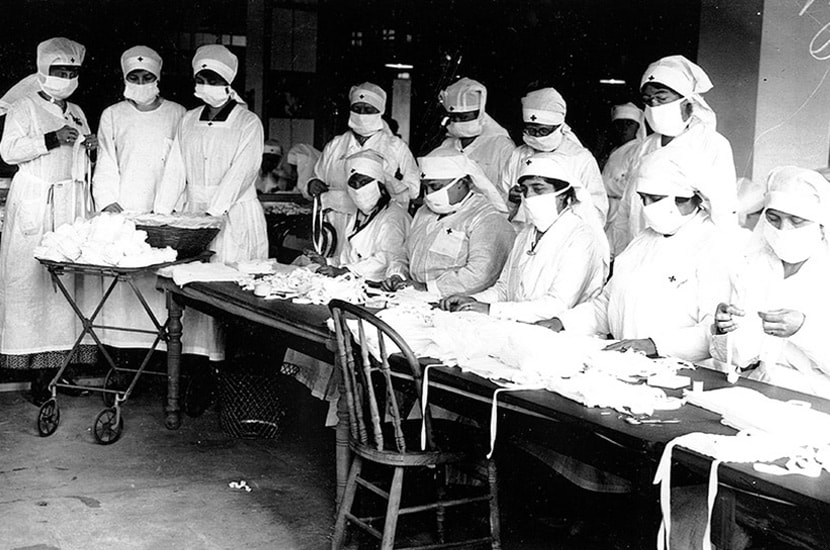
Red Cross Volunteers – Boston, MA
Massachusetts had been drained of physicians and nurses due to calls for military service, and no longer had enough personnel to meet the civilian demand for healthcare during the 1918 flu pandemic. Governor McCall asked every able-bodied person across the state with medical training to offer their aid in fighting the epidemic. Boston Red Cross volunteers assembled gauze influenza masks for use at hard-hit, Camp Devens in Massachusetts.
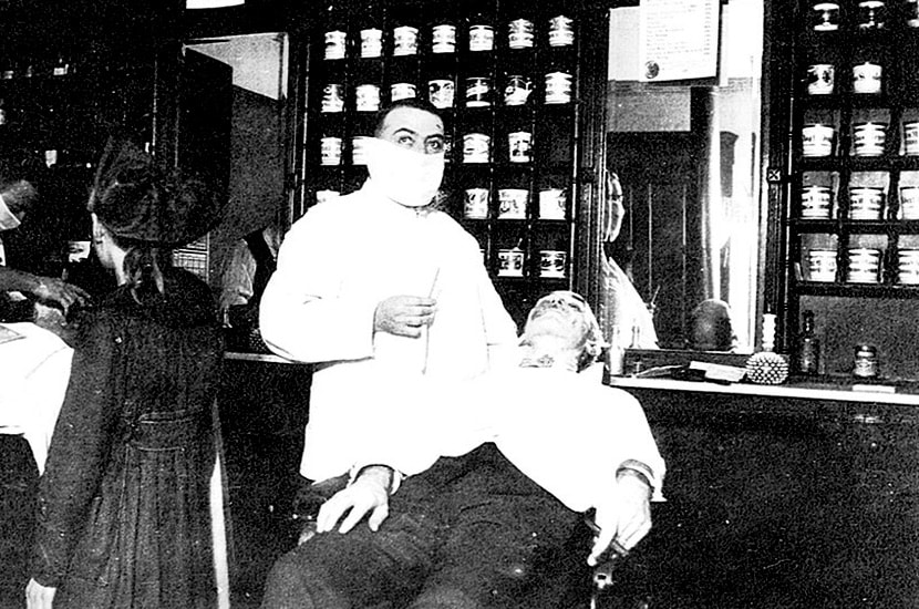
Local Barber – Cincinnati, OHA Cincinnati barber wears a mask while giving a customer a shave. Cincinnati’s barbers and downtown hotel employees were advised to wear a mask to “help in the fight to stamp out influenza”.
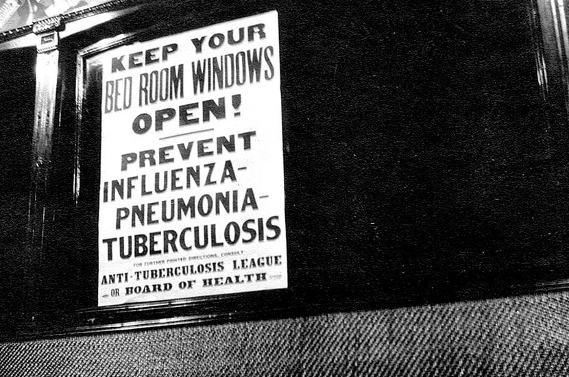
Flu Prevention Streetcar Sign – Cincinnati, OHA Cincinnati Board of Health Streetcar sign during the epidemic, educating passengers on how to prevent influenza, pneumonia, and tuberculosis. Cincinnati’s Health Officer and Mayor were quick to point out that the city was not in the midst of a public health crisis at the time. They told the press that “Cincinnati is endeavoring to prevent an epidemic of Spanish Influenza. There is no epidemic here. We are doing what other cities should have done – we are preventing.”
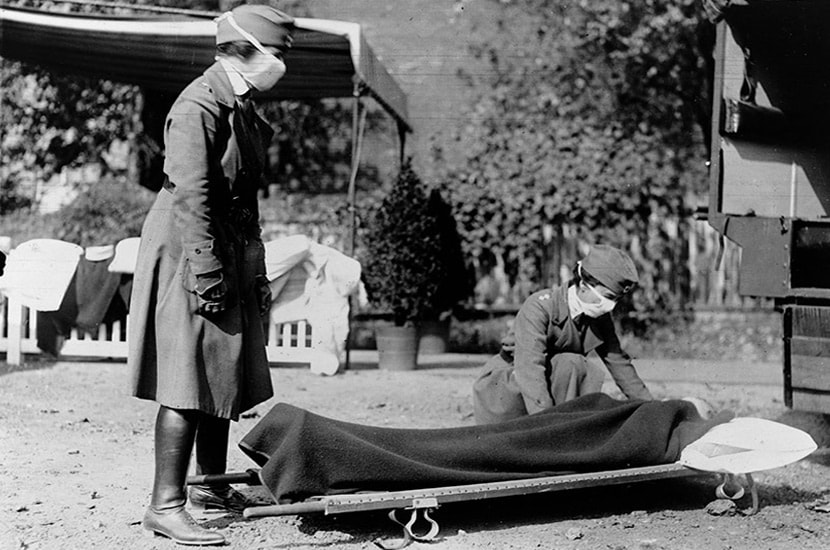
ed Cross Ambulance Demonstration – Washington, DCDemonstration at the Red Cross Emergency Ambulance Station in Washington, DC during the influenza epidemic. As the epidemic grew and total case number rose, the Red Cross put out desperate calls for trained nurses as well as untrained volunteers to help at the emergency centers. In October of 1918, Congress approved a $1 million budget for the U. S. Public Health Service to recruit 1000 medical doctors and over 700 registered nurses. Nurses were scarce at the time.

Red Cross Volunteers – Detroit, MIMotor Corps and Canteen volunteers from the Detroit chapter of the American Red Cross, taking a break from delivering supplies to flu victims. To prepare Detroit for what was to come from the pandemic, the Red Cross and Department of Health nurses cooperated together for home visits, food preparation and childcare.
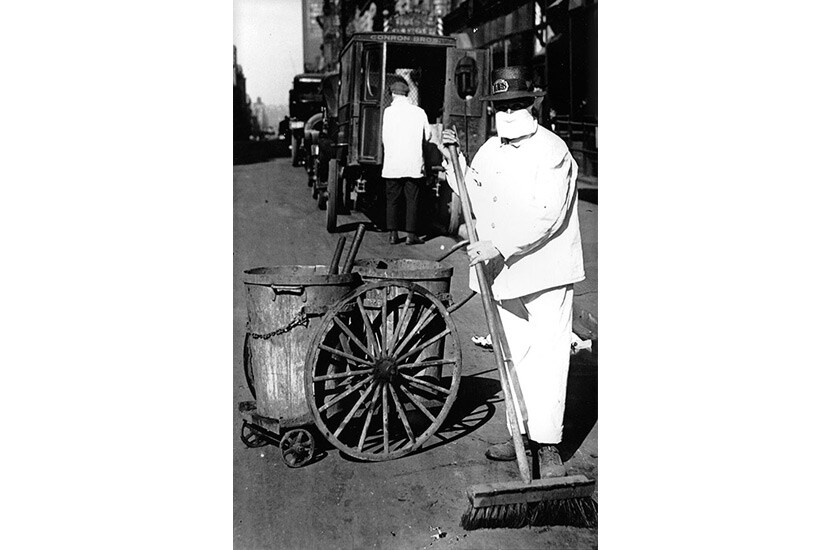
Street Sweeper – New York, NYA New York City street sweeper wears a mask while on the job, October 1918. Street sweepers were also arranged to work as gravediggers to assist with the bodies of influenza victims.

Open-air Police Court – San Francisco, CAAs the number of cases in San Francisco rose sharply, the city Board of Health issued a series of recommendations to the public on how to avoid contracting influenza including avoiding the use of streetcars during rush hour times, avoiding crowds, and paying attention to personal hygiene. To prevent crowding indoors, judges held outdoor court sessions. The Board of Health recommended all services and socials be held in the open air, if they weren’t cancelled.
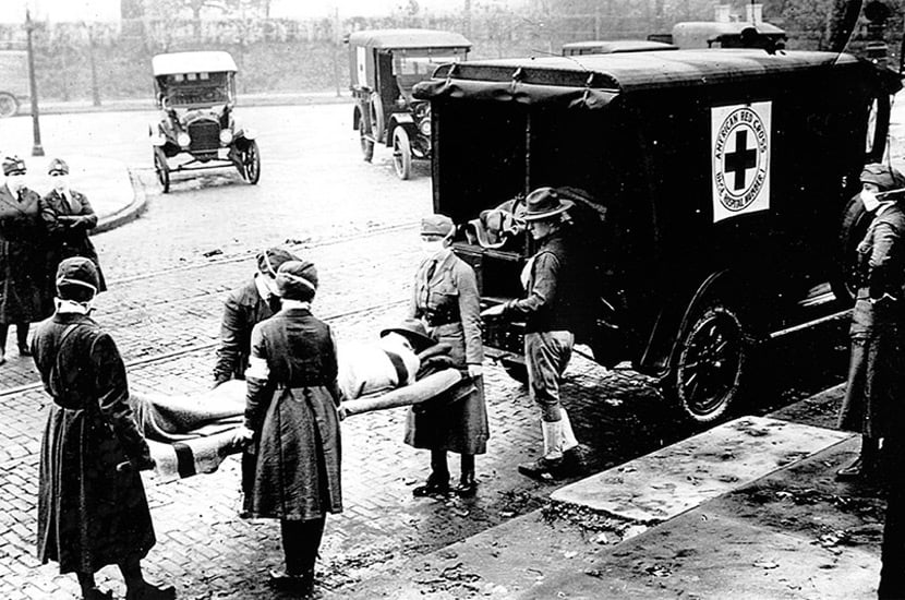
Ambulance Duty – St. Louis, MS
The Motor Corps of St. Louis chapter of the American Red Cross on ambulance duty during the influenza epidemic, October 1918. The Red Cross motor corps recruited volunteer drivers and automobiles to supplement ambulances and chauffeur nurses from one quarantined house to the next. Through this volunteer system, approximately 40 nurses cared for about 3,000 patients who otherwise had no access to private nursing.
Cholera in Somalia: The cumulative total of cases is 6394, including 42 associated deaths (case-fatality rate 0.7%) since the beginning of the current outbreak in December 2017
Tuesday, October 9th, 2018Outbreak update – Cholera in Somalia, 4 October 2018
Cholera in Niger: As of 1 October 2018, 3692 cases (14% of these were cases in Nigerian residents seeking care in Niger) with 68 deaths (case fatality rate = 1.8%) have been reported.
Tuesday, October 9th, 2018Cholera – Niger
On 15 July, the outbreak of cholera was officially declared by the Ministry of Public Health of Niger. The first three cases were residents of Nigeria from Jibiya Local Government Area (LGA) in Katsina State on the border with Niger. The cases were all from the same family and reportedly had an onset of symptoms in Jibiya LGA before seeking treatment on 5 July 2018 at a health facility in a bordering town in Niger. Vibrio cholerae serotype O1 Inaba was confirmed in stool samples from all three cases, one of which died within minutes of admission. In addition to these cases, six cases were reported in the following two days from villages in Niger located approximately 4km away from Jibiya LGA. Since then, the outbreak has continuously expanded geographically and in magnitude with peaks of around 400 cases reported in two weeks in August and in early September.
As of 1 October 2018, 3692 cases (14% of these were cases in Nigerian residents seeking care in Niger) with 68 deaths (case fatality rate = 1.8%) have been reported from twelve health districts in four regions: Dosso, Maradi, Tahoua, and Zinder. Four affected districts (Aguié, Guidam Roumji, Madarounfa, and Maradi commune) in Maradi Region and two affected districts (Birni Koni, and Mabalza) in Tahoua Region are on the border with Nigeria, while Gaya District in Dosso Region is close to the border with both Benin and Nigeria. Overall, 34 cases from four regions have been confirmed for Vibrio cholerae O1 Inaba at the Centre for Medical and Health Research (CERMES) in Niamey: Dosso Region (1), Zinder Region (3), Maradi Region (10) and Tahoua region (20).
Poor sanitary conditions in the affected areas have been implicated in the spread of the outbreak. Frequent population movement between Niger and neighbouring Katsina State in Nigeria, which is also experiencing an upsurge in cases of cholera, is likely impacting on the outbreak.
Public health response
The following public health response sections have been implemented:
-
- Multisectoral cholera outbreak coordination structures have been set up at the district, regional and national levels. A regular National Epidemic Management Committee (NEMC) meeting is being held under the leadership of the Ministry of Health (MoH).In addition, WHO is finalizing the WHO action plan to support the MoH.
- WHO is supporting the deployment of eight epidemiologists to the Maradi and Tahoua regions to support surveillance activities.
- Surveillance activities are being scaled up with support from WHO and other partners and the daily reporting and line listing of cases have been established.
- Cholera treatment centres have been put in place by the Ministry of Health with the support of Médecins Sans Frontières, and the Non-governmental Organization (NGO) ALIMA (partnered with the local NGO Bien Être de la Femme et l’Enfant au Niger (BEFEN)). In total, six treatment sites have been set up in the affected districts and initial medical supplies have been dispatched. Niger has laboratory capacity through the national laboratory (CERMES) which confirmed Vibrio cholerae serotype O1 Inaba.
- Social mobilization and risk communication activities are being scaled-up with support from UNICEF and Niger Red Cross, focusing on hygiene messages.
- Currently, water, sanitation and hygiene (WASH) activities are focusing on the distribution of aqua tabs.
WHO risk assessment
The current outbreak started in Madarounfa district in Maradi Region, one of the known hotspots for cholera along the Niger – Nigeria border, and has since spread to three geographically dispersed regions, including some of the most affected districts during previous cholera outbreaks. These areas are classified as high-risk areas for the spread of cholera given the presence of local risk factors such as poor hygiene and sanitary conditions coupled with significant population movement and trade between these districts and neighbouring areas in Nigeria. With the ongoing rainy season and the increase in cases in neighbouring Katsina State in Nigeria, the potential for further spread of the disease both within Niger and across the border with Nigeria is high. The population in the capital city Niamey as well as neighbouring Benin are at risk of being affected given the confirmation of cases in the Dosso Region which is a major trading hub on the border with Benin but also links the capital city Niamey. The bridge connecting Niger to Benin across the Niger River close to Gaya town has collapsed on 5 September, which may slow down population movement across this particular border but also forces the population to travel longer distances (possibly through Burkina Faso and Nigeria) to maintain economic and personal links with the other countries in the region.
The recent upsurge of cholera cases in Borno State in Nigeria also puts the population in Niger’s Diffa Region at risk given porous borders and mass movement in this area.
The last major cholera outbreak reported in Niger occurred in 2014 and involved more than 2000 cases.
WHO advice
WHO recommends proper and timely case management in Cholera Treatment Centres. Improving access to potable water and sanitation infrastructure, and improved hygiene and food safety practices in affected communities, are the most effective means of controlling cholera. Key public health communication messages should be provided.
WHO advises against any restriction to travel to and trade with the international community based on the information available on the current outbreak.
Cholera in Zimbabwe: As of 3 October 2018, 8535 cumulative cases, including 163 laboratory-confirmed cases, and 50 deaths have been reported (case fatality rate: 0.6%).
Tuesday, October 9th, 2018Cholera – Zimbabwe
Since the last Disease Outbreak News was published on 20 September (with data as of 15 September), an additional 4914 cases have been reported including 92 laboratory-confirmed cases.
The cholera outbreak in Harare was declared by the Ministry of Health and Child Care (MoHCC) of Zimbabwe on 6 September 2018 and notified to WHO on the same day. As of 3 October 2018, 8535 cumulative cases, including 163 laboratory-confirmed cases, and 50 deaths have been reported (case fatality rate: 0.6%). Of these 8535 cases, 98% (8341 cases) were reported from the densely populated capital Harare (Figure 1). The most affected suburbs in Harare are Glen View and Budiriro.
Of the 8340 cases for which age is known, the majority (56%) are aged between 5 and 35 years old. Males and females have been equally affected by the outbreak. From 4 September through 3 October, the majority of deaths were reported from health care institutions.
The pathogen is known to be Vibrio cholera O1 serotype Ogawa. Since confirmation on 6 September 2018, a multi-drug resistant strain has been identified and is in circulation; however, this does not affect the treatment of most cases, where supportive care such as rehydration solutions are used. Antibiotics are only recommended for severe cases. Furthermore, the antibiotic which is being used for severe cases in Harare is Azithromycin which remains effective in the majority of cases.
Contaminated water sources, including wells and boreholes are suspected as the source of the outbreak.
Figure 1: Cholera cases in Harare, Zimbabwe from 4 September through 3 October 2018
igure 2: Cholera cases in Zimbabwe from 4 September through 1 October 2018
Public health response
-
- On 3 October 2018, an oral cholera vaccine mass vaccination campaign started in Harare City and surrounding areas such as Chitungwiza and Epworth. WHO is supporting the MoHCC on a strategy for rolling out the vaccination campaign, as well as implementing the campaign and sensitizing the public about the vaccine. More than 600 health workers have been trained to carry out the campaign. On 27 September 2018, 500 000 doses have arrived in Harare. In total, 2.7 million doses have been approved for two rounds of vaccination.
- WHO and experts from the Global Outbreak Alert and Response Network (GOARN) are providing technical oversight into case management and providing guidance on the interpretation of laboratory findings to guide the choice of antibiotics.
- Four cholera treatment centres (CTCs) have been established. UNICEF has prepositioned seven tents at Glenview for the CTC and Oxfam is providing mobile toilets in three CTCs.
- The key risk communication and community engagement interventions have been on raising awareness on cholera prevention through the mass media and social media, and working with specific community groups, including Apostolic sect leaders and Apostolic women’s groups.
- Sixty volunteers have been deployed to provide risk communication, community engagement and social mobilization support to CTCs in Budiriro and Glen View. Health and hygiene promotion is taking place through drama shows at schools and business centres, roadshows and door-to-door visits, which also focuses on identification and case referral.
- Water, sanitation and hygiene (WASH) activities include enforcement of regulations for food vendors, City of Harare fixing burst water pipes and increasing the water supply to hotspots, with private sector players supporting installation of water tanks and water trucking.
- UNICEF is supporting distribution of non-food items (soap, buckets), along with Oxfam, Christian Care, Mercy Corps and Welthungerhilfe (WHH), as well as key components of community mobilization.
- WHO has sent supplies to treat 3800 people and arrangements are in place for additional supplies to arrive in the coming days. In addition, more than 44 000 litres of ringers lactate from South Africa have arrived in country and the RDTs are being cleared from the airport.
- Since the cholera outbreak was declared on 6 September 2018, weekly meetings of the Inter-Agency Coordination Committee on Health (IACCH) have been held.
- On 12 September 2018, following the declaration of the cholera outbreak as a state of disaster, the Cabinet Committee on Emergency Preparedness and Disaster Management was reactivated.
- On 18 September 2018, the national government set up an inter-ministerial committee on the cholera outbreak, involving all major government stakeholders, to provide leadership and to monitor the cholera response efforts and provide regular briefs to the President.
- On 21 September 2018, the National Emergency Operations Centre (EOC) was activated, with support provided by local business organizations. The Incident Command Structure (ICS) was finalized and will be published by the EOC.
- On 1 October 2018, Econet began fixing Information and Communications Technology equipment in the EOC in MoHCC of Zimbabwe to support real time reporting.
- On 29 September 2018, a rapid assessment of surveillance was conducted in coordination with the United States Centers for Disease Control and Prevention (US CDC).
WHO risk assessment
The outbreak started on 5 September and the number of cases notified per day continues to rapidly increase, particularly in Glen View and Budiriro suburbs of Harare. Cases with epidemiological links to this outbreak have been reported from other provinces across the country. Glen View, which is the epicentre of the outbreak, is an active informal trading area where people come from across the city and the rest of the country to trade. Key risk factors for cholera in Zimbabwe include the deterioration of sanitary and health infrastructure and increasing rural-urban migration which further strains the water and sanitation infrastructure. Since the beginning of the outbreak, 135 cases have been reported from provinces outside Harare. With the upcoming rainy season in November, there is a concern that cases may increase in the hotspots. In Harare, contaminated water from boreholes and wells is suspected to be the source of the outbreak. Sixty-nine percent of the population in Harare relies on these boreholes and wells as a source of water. The water supply situation in Harare remains dire due to the high demand of water that is not being met by the city supply though this is a focus of response efforts. The country’s available response capacities are overstretched as authorities are already responding to a large typhoid outbreak which started in August 2018. WHO assessed the overall public health risk to be high at the national level and moderate at the regional and low at global levels.
WHO advice
WHO recommends proper and timely case management in CTCs. Increasing access to potable water, improving sanitation infrastructure, and strengthening hygiene and food safety practices in affected communities are the most effective means to prevent and control cholera. Key public health communication messages should be provided to the affected population.
WHO advises against any restrictions on travel or trade to or from Zimbabwe based on the information currently available in relation to this outbreak.
For further information, please refer to:


![[Image of probabilities of 34-kt winds]](https://www.nhc.noaa.gov/storm_graphics/AT14/refresh/AL142018_wind_probs_34_F120+png/033350.png)
![[Image of initial wind radii]](https://www.nhc.noaa.gov/storm_graphics/AT14/refresh/AL142018_current_wind+png/033350_current_wind_sm.png)


![[Image of cumulative wind history]](https://www.nhc.noaa.gov/storm_graphics/AT14/refresh/AL142018_wind_history+png/033350_wind_history.png)
![[Image of WPC Flash Flooding/Excessive Rainfall Outlook]](https://www.nhc.noaa.gov/storm_graphics/AT14/refresh/AL1418WPCERO+gif/033350WPCERO_sm.gif)