Archive for September, 2019
Personal Health Preparedness: CDC
Sunday, September 8th, 2019A major public health emergency like a hurricane or a lengthy power outage can limit your access to supplies and services for several days, weeks, or even months. Be prepared with safe water and food, basic supplies, and the personal items you need to protect your health in an emergency.
Personal Needs:
- An emergency water supply.
- Nonperishable and ready-to-eat food, including specialty foods—such as nutrition drinks and ready-to-feed formula—for infants, and people with dietary restrictions, food allergies and sensitivities, and medical conditions such as diabetes.
- Home use medical devices and assistive technologies devices, such as hearing aids, contact lenses, and contact lens solution.
- Medical supplies.
- First aid supplies.
- For more essentials, click here.
Prescriptions:
- A 7- to 10-day emergency supply of essential or priority medications stored in a waterproof, childproof container.
- An up-to-date list, including
- All prescription medications, including dosage amounts and the names of their generic equivalents
- Medical supply needs
- Known allergies
- Nonprescription drugs, including pain and fever relievers, diuretics, antihistamines, and antidiarrheal medications stored in childproof containers.
- For more information on prescriptions, click here.
Paperwork:
- Copies of insurance cards and medical records, including
- Health insurance card
- Immunization and vaccination records
- Vital records (e.g., birth and death certificates and adoption records) and personal identification, including
- Passport
- Driver’s license
- Social Security card
- Copies of current medical emergency plans, such as advance directives and asthma action plans.
- For more information on paperwork, click here.
Power Sources:
- A flashlight or head lamp.
- Extra batteries in standard sizes, such as AA and AAA.
- Car charger(s) and adapters for electricity-dependent equipment and devices.
- A generator with at least 20 feet of extension cord(s).
- Battery-powered smoke alarms and carbon monoxide (CO) detectors.
- For more power sources, click here.
Practical Skills:
- Learn the right way to wash your hands. Handwashing is one of the best ways to protect yourself, your family, and others from getting sick.
- Learn how to use a portable generator safely to prevent CO poisoning.
- Learn how to create and store an emergency water supply.
- For more practical skills, click here.
Typhoon Lingling
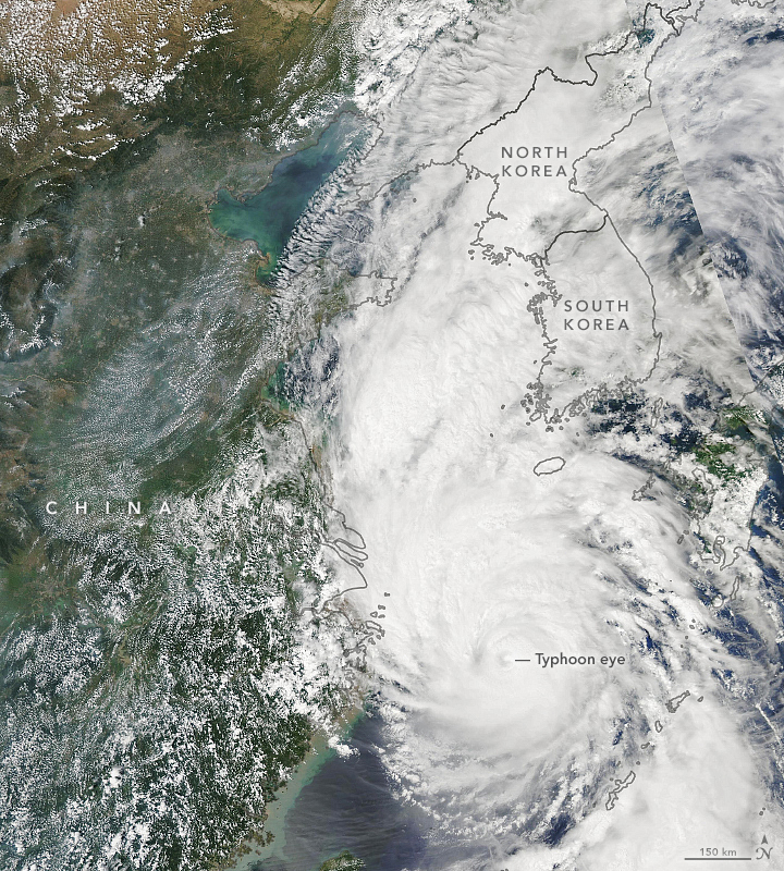
Saturday, September 7th, 2019“…….With maximum sustained winds of around 160 kilometers (95 miles) per hour, the typhoon is now headed toward South and North Korea.
The Moderate Resolution Imaging Spectroradiometer (MODIS) on NASA’s Aqua satellite acquired this image of the typhoon on September 6, 2019. The storm was moving north at 40 kilometers (25 miles) per hour and is expected to reach the Yellow Sea on September 7. It is then forecasted to make landfall in North Korea, according to the Japan Meteorological Agency.
The typhoon is expected to weaken as its outer bands interact with land on South Korea, but forecasters still expect torrential rainfall and damaging winds. Forecasters predict around 75 to 150 millimeters (3 to 6 inches) of rainfall and a storm surge, both of which may cause flooding and landslides.
Typhoon Lingling is the thirteenth tropical cyclone (typhoon or tropical storm) in the North Pacific this year. However, the Korean Peninsula typically sees just one landfalling storm per year…..”
NASA Earth Observatory image by Lauren Dauphin, using MODIS data from NASA EOSDIS/LANCE and GIBS/Worldview. Story by Kasha Patel.
NASA: Dorian skirts the eastern shoreline
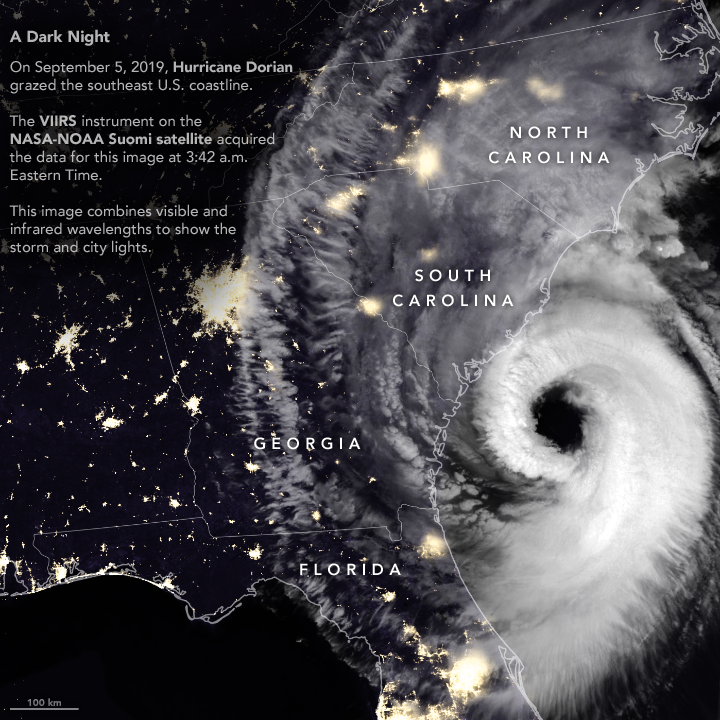
Friday, September 6th, 2019After devastating the Bahamas and grazing Florida and Georgia, Hurricane Dorian rebounded and raked the coast of South Carolina with strong winds, heavy rains, and a storm surge. Wind, falling trees, and flooding damaged power infrastructure in coastal areas of the southeast U.S.
The Visible Infrared Imaging Radiometer Suite (VIIRS) on the Suomi NPP satellite captured this nighttime composite image as the storm approached the coast at 3:42 a.m. Eastern Time (07:42 UTC) on September 5, 2019. At the time, Dorian packed maximum sustained winds of 115 miles (185 kilometers) per hour and was moving north at 8 miles per hour.
The VIIRS sensor observed thick cloud bands circulating around Dorian’s large eye, the part of the storm with mostly calm weather and the lowest atmospheric pressure. Hurricane eyes average about 20 miles (32 kilometers); the National Hurricane Center reported Dorian’s eye had a diameter of 50 miles (80 kilometers) around the time this image was acquired. Thinner clouds—part of the storm’s higher-level outflow—extended well inland across Georgia, South Carolina, and North Carolina.
The VIIRS image was captured by the sensor’s day-night band, which detects light in a range of wavelengths from green to near-infrared and uses filtering techniques to observe signals such as gas flares, city lights, and reflected moonlight. Infrared observations from VIIRS were used to enhance the visibility of clouds. Optical MODIS satellite data was layered into the image to make it easier to distinguish between ocean and land surfaces.

It is not possible to identify the locations of power outages based on the VIIRS night light image alone. However, as of 2 p.m. on September 5, several utility companies and Poweroutages.us were reporting more than 240,000 outages in South Carolina. The hardest hit area was Charleston County, where companies were reporting more than 130,000 outages.
In the coming days, forecasters expect Dorian to move near or over the coast of North Carolina and then toward New England and Nova Scotia.
NASA Earth Observatory images by Joshua Stevens, using VIIRS data from the Suomi National Polar-orbiting Partnership, and power outage data courtesy of PowerOutage.us. Story by Adam Voiland.


