Archive for the ‘Fires/Wildfires’ Category
A barge carrying a New Year fireworks display caught fire at an Australian beach injuring 2 and causing thousands of people on the beach to be moved to safety
Monday, January 1st, 2018NASA: California’s December Inferno
Sunday, December 31st, 2017
It is rare for large wildfires to burn in California in December, which is usually a wet month for the state. In most years, a few hundreds acres might burn. The 2006 Shekell fire in Ventura charred 13,600 acres, making it the largest December fire in the state between 2000 and 2016.
In 2017, the Thomas fire shattered the record for December and may soon eclipse the worst blaze in any month. After burning for 16 days, the massive fire had scorched 272,000 acres (110,000 hectares or 425 square miles) and was just 60 percent contained. That made it the second largest fire on record in California, trailing only the Cedar fire, which burned 273,246 acres in 2003.
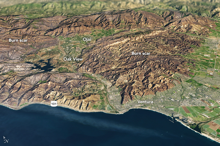
The Operational Land Imager (OLI) on Landsat 8 captured an image of the Thomas fire scar on December 18, 2017. The natural-color Landsat 8 image was draped over an ASTER-derived Global Digital Elevation Model, which shows the topography of the area. The fire raged first near Ventura, then burned the hills around communities of Ojai and Oak View. Firefighters put up a fierce fight and managed to prevent flames from descending into the valley towns. Flames then pushed west toward Summerland, Montecito, and Santa Barbara. As of December 20, the fire was still spreading along the northern edge of the burn scar.
Authorities reported that more than 1,200 structures—most of them in Ventura County—have been destroyed. Several factors came together to make the blaze difficult to control. An usually wet winter and spring in early 2017 caused vegetation to flourish. Then the dry season turned out to be excessively dry, and rains also have been scarce in the typically wetter months of November and December. All of that vegetation dried out and was primed to burn. Once the fire started, warm temperatures and unusually fierce Santa Ana winds caused the fire to spread rapidly.
After nearly two weeks of red flag conditions, a break in the weather has allowed firefighters to beat back the flames in the past few days. But fire officials still do not expect the Thomas fire to be completely contained until January 2018.
-
References
- AccuWeather (2017, December 20) Why the devastating California wildfires have been so unusual, extreme this December. Accessed December 20, 2017.
- InciWeb (2017) Thomas Fire. Accessed December 20, 2017.
- Los Angeles Times (2017, December 30) Another day of reckoning: Return of powerful winds make Thomas fire dangerous again. Accessed December 20, 2017.
- NBC (2017, December 19) Map: How the Thomas Fire Grew Into One of California’s Largest Wildfires. Accessed December 20, 2017.
- The Wrap (2017, December 11) How They Saved Ojai: A Letter From a Town to Its Firefighters. Accessed December 20, 2017.
NASA Earth Observatory image by Joshua Stevens, using Landsat data from the U.S. Geological Survey and ASTER GDEM data from NASA/GSFC/METI/ERSDAC/JAROS, and U.S./Japan ASTER Science Team. Story by Adam Voiland.
- Instrument(s):
- Terra – ASTER
- Landsat 8 – OLI
At least 14 died and 16 were injured when a fire engulfed an upscale rooftop restaurant in central Mumbai.
Friday, December 29th, 2017‘…….“There was a stampede and someone pushed me,” said Sulbha Arora, a gynaecologist, in a tweet. “People were running over me even as the ceiling above me was collapsing in flames. Still don’t know how I got out alive.”……..Police filed a complaint against Hitesh Sanghvi, Jigar Sanghvi, and Abhijit Manka, owners of a restaurant in the building, and charged them with causing death due to negligence……’
Major Bronx apartment fire kills at least 12
Friday, December 29th, 2017NASA: Thomas Fire’s impact on air quality
Wednesday, December 20th, 2017
After more than a week of burning, the wildfires in Southern California continue to loft a nasty mixture of aerosols and gases into the atmosphere.
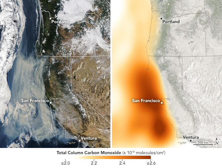
On December 11, 2017, the Moderate Resolution Imaging Spectroradiometer (MODIS) on NASA’s Aqua satellite acquired a natural color image (left) of smoke billowing from the Thomas Fire in Ventura County, California. By that day, the fire had already burned 230,500 acres (93,000 hectares or 360 square miles).
The corresponding map (right) shows the concentration of carbon monoxide in the area, based on data collected by the Atmospheric Infrared Sounder (AIRS) on Aqua. The concentrations reflect total “column” amounts of the gas, measured vertically through the atmosphere by AIRS. Orange areas indicate the highest concentrations of carbon monoxide.
When fires burn through a fuel source—such as vegetation, gasoline, or coal—emissions can include everything from hydrocarbons, nitrogen oxides, and carbon monoxide. Close to the source of the fire, the air quality on that day was rated unhealthy. As the image pair shows, smoke and carbon monoxide appear offshore as well.
Dejian Fu, an atmospheric scientist at NASA’s Jet Propulsion Laboratory, thinks that the carbon monoxide plume likely stemmed from the burning onshore and then blew out over the Pacific Ocean. This map shows the gas concentration up to an altitude of about 5 kilometers above the surface.
Carbon monoxide contributes to reactions that produce ground-level ozone, a harmful pollutant. It can also make breathing difficult to dangerous when trapped near the ground.
-
References and Further Reading
- NASA Earth Observatory (2017, December 11) Fires Continue to Rage in Southern California.
- NASA Earth Observatory (2000, March) Fire & Carbon Monoxide.
NASA Earth Observatory images by Joshua Stevens, using MODIS data from LANCE/EOSDIS Rapid Response and AIRS data from the Goddard Earth Sciences Data and Information Services Center (GES DISC). Story by Kathryn Hansen.
The Thomas fire: The 2nd largest in modern California history (272,000 acres)
Wednesday, December 20th, 2017
Fire Information Report for Thomas
Report Date: 20-DEC-17
| Burnt Area: | 271,000 Acres |
| Location: | Ventura County, California |
| Cause: | Undetermined |
| Incident Team Type: | IMT Type 1 |
| Containment Status: | 55% contained |
| Expected Containment: | 07-Jan-18 |
New evacuation orders were issued in Santa Barbara County on Saturday as the massive Thomas fire took aim at the hills above Montecito.
Sunday, December 17th, 2017IMSR Summary
December 16th, 2017
National Preparedness Level
Level 2
National Fire Activity
Initial attack activity: Light (35) new fires
New large incidents: 2
Large fires contained: 3
Uncontained large fires: 4
Area Command teams committed: 0
NIMOs committed: 0
Type 1 IMTs committed: 2
Type 2 IMTs committed: 1
Source:
Incident Management Situation Report
Fire Information Report for Thomas
Report Date: 17-DEC-17
| Burnt Area: | 256,000 Acres |
| Location: | Ventura County, California |
| Cause: | Undetermined |
| Incident Team Type: | IMT Type 1 |
| Containment Status: | 40% contained |
| Expected Containment: | 07-Jan-18 |
U.S. Department of Agriculture’s Forest Service presence in Southern California has increased, as nearly 950 personnel are now engaged in the effort to fight raging fires and save lives.
Saturday, December 16th, 2017USDA’s Forest Service Crews Increase in California
USDA Office of Communications sent this bulletin at 12/15/2017 05:15 PM EST
You are subscribed to USDA Office of Communications.
Release No. 0166.17
https://www.youtube.com/watch?v=PoyLMS_r8Ec
Contact: USDA Press
Phone: (202) 720-4623
Email: press@oc.usda.gov
USDA’s Forest Service Crews Increase in California
Washington, D.C., December 15, 2017– U.S. Department of Agriculture’s (USDA) Forest Service presence in Southern California has increased, as nearly 950 personnel are now engaged in the effort to fight raging fires and save lives. Critical fire weather conditions continue to threaten large portions of CA after fires have burned across the state for weeks. Gusty winds, extremely low relative humidity and record low fuel moisture will allow explosive growth on any new start in the windy areas during peak heating hours……
2017 marks a year of unprecedented wildfire activity. More than two million acres of national forest land have burned, along with millions more acres of state and privately-owned land.
Currently still burning, the Thomas Fire in Ventura County has already consumed over 250,000 acres, 117,000 acres of which are in Los Padres National Forest. With two reported fatalities and as many as 18,000 homes threatened, firefighters remain engaged in protecting homes and establishing direct firelines where possible. Crews from USDA’s Forest Service, California Fire, and the National Guard continued to actively engage in suppressing small spot fires around the southeastern portion of the perimeter.
###
FEMA: Thomas Fire – California ( Now the 4th largest fire in California history )
Friday, December 15th, 2017Current Situation : 12/15/17
Counties: Thomas (Ventura and Santa Barbara)
Acres burned: 249,500 (+11,000)
Percent contained: 35% (+5%)
Mandatory evacuations: 93k
18,000 structures threatened
177 Homes 44 Other : Damaged
731 Homes 241 Other : Destroyed
2 (1+) / 0: Fatalities
• Burning in Santa Barbara county (pop. 445k) and Ventura county (pop. 851k)
• Now the 4th largest fire in California history Impacts
• Evacuations remain in effect for over 93k residents
• Shelters: 3 open / 279 (-10) occupants (ARC Midnight Shelter Count as of 5:32 a.m. EST)
• A boil water advisory remains in effect for both counties State/Local Response
• Governor declared a State of Emergency; National Guard deployed
• CA EOC at Full Activation
• NV EOC at Partial Activation (supporting CA wildfires)
• UT EOC at Monitoring (supporting CA wildfires) FEMA Response
• Emergency Disaster Declaration approved on December 8, 2017
• Region IX RWC at Steady State; RRCC not activated
• Region IX IMAT-1 & 2 deployed to CA EOC
• Region IX LNO & Bothell MERS deployed to Southern Regional EOC
• Defense Coordinating Element (DCE) activated

