Archive for the ‘Flood’ Category
NWS: What is the difference between a Flood Watch and a Flood Warning?
Saturday, September 9th, 2017What is the difference between a Flood Watch and a Flood Warning issued by the National Weather Service?
- Flash Flood Warning: Take Action! A Flash Flood Warning is issued when a flash flood is imminent or occurring. If you are in a flood prone area move immediately to high ground. A flash flood is a sudden violent flood that can take from minutes to hours to develop. It is even possible to experience a flash flood in areas not immediately receiving rain.
- Flood Warning: Take Action! A Flood Warning is issued when the hazardous weather event is imminent or already happening. A Flood Warning is issued when flooding is imminent or occurring.
- Flood Watch: Be Prepared:A Flood Watch is issued when conditions are favorable for a specific hazardous weather event to occur. A Flood Watch is issued when conditions are favorable for flooding. It does not mean flooding will occur, but it is possible.
- Flood Advisory: Be Aware: An Flood Advisory is issued when a specific weather event that is forecast to occur may become a nuisance. A Flood Advisory is issued when flooding is not expected to be bad enough to issue a warning. However, it may cause significant inconvenience, and if caution is not exercised, it could lead to situations that may threaten life and/or property.
NWS: What to do before the Flood
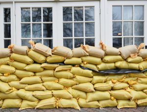
Saturday, September 9th, 2017- If you have access to sandbags or other materials, use them to protect your home from flood waters if you have sufficient time to do so. Filling sandbags can take more time than you may think.
- Have a professional install check-valves in plumbing to prevent flood waters from backing up into the drains of your home. Make sure your sump pump is working and consider having a backup. Make sure your electric circuit breakers, or fuses, are clearly marked for each area of your home.
- Since standard homeowners insurance doesn’t cover flooding, ensure coverage by contacting your insurance company or agent to purchase flood insurance. This must be done before there is even a threat of flooding as insurance companies stop issuing policies if there is a threat of flooding. (i.e. an approaching hurricane). Many flood insurance policies take at least 30 days to go into effect so even if you can buy it as a storm is approaching, it may not protect your investment.
NWS: What to do during a Flood
Saturday, September 9th, 2017Monitor local radio and television (including NOAA Weather Radio), internet and social media for information and updates.
Get out of areas subject to flooding and get to higher ground immediately.

If told to evacuate, do so immediately. Be sure to lock your home as you leave. If you have time, disconnect utilities and appliances.
Don’t go into a basement, or any room, if water covers the electrical outlets or if cords are submerged. If you see sparks or hear buzzing, crackling, snapping or popping noises –get out! Stay out of water that may have electricity in it!
Do not walk through flood waters. It only takes six inches of moving water to knock you off your feet. If you are trapped by moving water, move to the highest possible point and call 911 for help.
Do not drive into flooded roadways or around a barricade; Turn Around, Don’t Drown! Water may be deeper than it appears and can hide many hazards (i.e. sharp objects, washed out road surfaces, electrical wires, chemicals, etc). A vehicle caught in swiftly moving water can be swept away in a matter of seconds. Twelve inches of water can float a car or small SUV and 18 inches of water can carry away large vehicles.
NWS: What to do after the Flood
Saturday, September 9th, 2017When flood waters recede, the damage left behind can be devastating and present many dangers. Images of flood destruction depict destroyed homes and buildings, damaged possessions, and decimated roadways. However, what you can’t see can be just as dangerous. Floodwaters often become contaminated with sewage or chemicals. Gas leaks and live power lines can be deadly, but are not obvious at first glance.
Standing water hides many dangers including toxins and chemicals. There may be debris under the water and the road surface may have been compromised.
NWS: Turn around, don’t drown
Saturday, September 9th, 2017
Turn Around Don’t Drown® Warning Signs
|
Houston: The cleanup of the millions of pounds of debris already crowding curbs and edging onto streets will take months and cost billions of dollars.
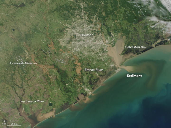
Thursday, September 7th, 2017NASA: The brown rivers and bays, full of flood water from Hurricane Harvey.
Saturday, September 2nd, 2017

On August 31, 2017, the Moderate Resolution Imaging Spectroradiometer (MODIS) on NASA’s Terra satellite captured this image of the Texas coast and the Houston metropolitan area. Note the brown rivers and bays, full of flood water from Hurricane Harvey. Along the coast, muddy, sediment-laden waters from inland pour into a Gulf of Mexico that also was churned up by the relentless storm.
NASA Earth Observatory image by Jesse Allen, using data from the Land Atmosphere Near real-time Capability for EOS (LANCE). Caption by Michael Carlowicz.
- Instrument(s):
- Terra – MODIS
the crisis at Crosby has exposed the vulnerability of hundreds of chemical plants in low-lying areas across the U.S. Gulf Coast.
Friday, September 1st, 2017“…..The plant had 19.5 tons of organic peroxides of various strengths, all of them requiring refrigeration to prevent ignition.
But the power went out, and then the floodwaters came and knocked out the plant’s generators. A liquid nitrogen system faltered. In a last-ditch move, the workers transferred the chemicals to nine huge refrigerated trucks, each with its own generator, and moved the vehicles to a remote section of the plant.
That was doomed to fail, too. Six feet of water swamped the trucks, and the final 11 workers gave up. At 2 a.m. Tuesday, they called for a water evacuation and left the plant to its fate…….”
“…..Texas has more than 1,300 chemical plants, a large number of them in low-lying areas near the coast that are vulnerable to flooding. …..”
NASA: Soil Moisture Satellite Observes Harvey’s Wrath
Friday, September 1st, 2017
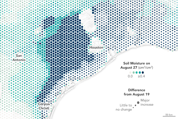
Hurricane Harvey has dropped record-breaking amounts of rainfall, particularly around Houston, Texas, since making landfall on August 25, 2017. Yesterday, we showed satellite-based estimates of rainfall, while today’s image shows the storm’s consequences from a different but complementary perspective.
The map above depicts soil conditions around south Texas on August 27 compared to values observed on August 19. Colors on the map represent the amount of surface soil moisture, with the darkest colors representing soil that is saturated or nearly so. The size of each hexagon represents how much the level of soil moisture changed from the days before Harvey to the middle of the event (the most recent date for which we have data). Note that data are sparse in Houston itself, as much of that area is covered by impervious surfaces (roads, buildings, and infrastructure).


