Archive for the ‘Flood’ Category
Today’s FEMA SitRep on Puerto Rico and USVI after the hurricanes
Sunday, October 22nd, 2017Puerto Rico
NEJM: The View from Puerto Rico — Hurricane Maria and Its Aftermath
Friday, October 13th, 2017The View from Puerto Rico — Hurricane Maria and Its Aftermath
Carmen D. Zorrilla, M.D.
DOI: 10.1056/NEJMp1713196
“…..As of 16 days after the hurricane, 25 hospitals were working, only 9.2% of people had power, 54% had water, 45% had cell phone service, and the Federal Emergency Management Agency had distributed 433,000 food packages and 42,000 gallons of water…….”
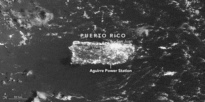
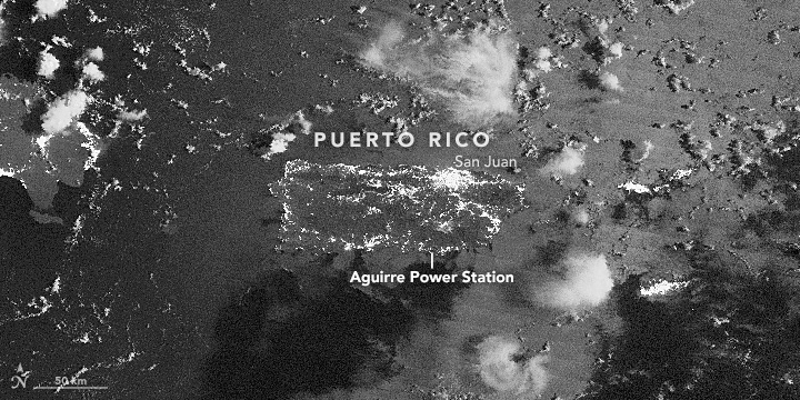
Late on September 21, 2016, a fire at a power plant substation in southern Puerto Rico triggered a cascade of problems across the island’s aging electrical grid. The event knocked out power to nearly 1.5 million customers.
From space, the effects appeared dramatic. The Visible Infrared Imaging Radiometer Suite (VIIRS) on the Suomi NPP satellite captured these nighttime images of Puerto Rico before and after the outage. The upper image was acquired at 2:50 a.m. local time (06:50 Universal Time) on September 21, 2016; the lower image shows the island at 2:31 a.m. local time (06:31 Universal Time) on September 22, 2016.
Both images were captured by the VIIRS “day-night band,” which detects light in a range of wavelengths from green to near-infrared and uses filtering techniques to observe signals such as gas flares, city lights, and reflected moonlight. Note that the brightness of the ocean surface varies between the images due to slightly different angles of moonlight on the water. Use the slider tool to compare the images.
The widespread loss of electricity appears across Puerto Rico in all areas outside of the San Juan metropolitan area. Ponce, Humacao, Aguadilla, Arecibo, and Mayagüez all had large numbers of customers losing power.
The fire occurred at the Aguirre power plant in Salinas after a power switch overheated. This caused a 2,000-gallon (8,000 liter) mineral oil tank to explode and trigger a fire across a 3-acre (1 hectare) area. According to news reports, the collapse of the power system has caused widespread losses of water and air conditioning, traffic jams, and business and school closures.
“With something of this scale, we’re not just seeing an outage. We are seeing a complete stoppage in the rhythms of daily life,” said Miguel Román, a scientist at NASA Goddard Space Flight Center and member of the Suomi NPP science team.
“These nighttime satellite images help bring a level of situational awareness so we can clearly identify the extent of the impacts into key lifelines of a city’s infrastructure,” added David Green, the program manager for NASA’s Disaster Response Program. “We hope that power, civil, and health authorities can use imagery and data like this to map the extent of affected areas and prioritize their personnel and resources to restore critical infrastructure.”
-
References
- El Nuevo Dia (2016, September 21) Colapso total del sistema de la AEE en Puerto Rico. Accessed September 22, 2016.
- CNN (2016, September 22) Nearly 1.5 million without power in Puerto Rico. Accessed September 22, 2016.
- NPR (2015, May 7) Power Problems: Puerto Rico’s Electric Utility Faces Crippling Debt. Accessed September 22, 2016.
- NY1 (2016, September 22) Power Slowly Being Restored to Blacked-out Puerto Rico. Accessed September 22, 2016.
- The New York Times (2016, September 22) Fire at Power Plant Leaves Puerto Rico in the Dark. Accessed September 22, 2016.
- U.S. Energy Information Administration (2016, September 22) Puerto Rico Territory Energy Profile. Accessed September 22, 2016.
-
-
Further Reading
- NASA Earth Observatory (2012, October 5) Out of the Blue, Into the Black.
- The Washington Post (2014, August 27) NASA scientist takes measure of the planet.
- NASA Applied Sciences Program Disasters. Accessed September 22, 2016.
-
NASA Earth Observatory image by Jesse Allen, using VIIRS day-night band data from the Suomi National Polar-orbiting Partnership provided by Miguel Roman (NASA/GSFC). Suomi NPP is the result of a partnership between NASA, the National Oceanic and Atmospheric Administration, and the Department of Defense. Caption by Adam Voiland.
- Instrument(s):
- Suomi NPP – VIIRS
Puerto Rico: Grappling with growing health concerns due to a lack of reliable access to medical care, supplies and clean water.
Friday, October 6th, 2017- The official death count has risen to 34 from 16.
- Thr deaths were due to failed oxygen delivery following electrical outages.
- Other causes of death include suicide following the storm, heart attacks and drownings.
- Two deaths occurred during search and rescue operations.
9/28/17: Puerto Rico Landscape Ravaged by Hurricane Maria
Thursday, September 28th, 2017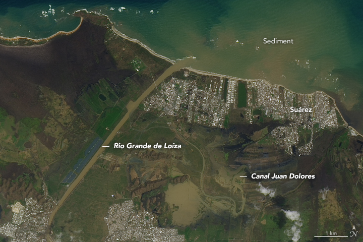
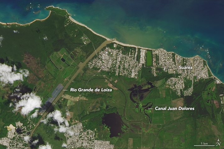
Hurricane Maria tore across Puerto Rico on September 20, 2017, ravaging both urban and rural areas with category 4 winds and intense rainfall for several days. Most of the electric power grid and telecommunications network was knocked offline; towns both inland and at the coast were swamped with floodwaters and storm surges; and the lush green landscape turned brown from damaged vegetation and mud and debris deposits.
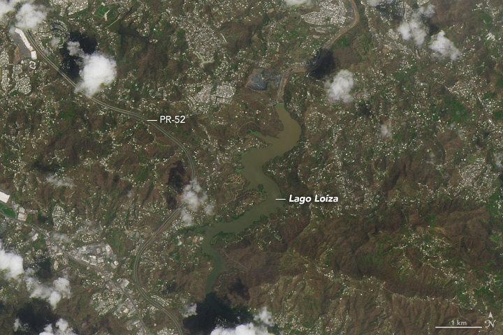
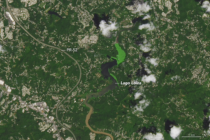
On September 26, 2017, the Operational Land Imager (OLI) on the Landsat 8 satellite captured some of the first natural-color satellite images of Puerto Rico after Hurricane Maria. Cloud cover is common in the tropics and has been particularly bad in the days since the storm, so researchers have been unable to see much from orbit.
The images above show the Rio Grande de Loíza, the island’s largest river by volume, where it meets the Atlantic Ocean several miles east of San Juan and west of Suárez. The images below show an interior portion of the island around the Lago Loíza reservoir, south of San Juan and north of Caguas. In each pair the second image shows the same area one year ago (September 23, 2016) so as to provide a proper seasonal comparison. (Note: the green color of the lake in 2016 could be an algae bloom or some other form of water vegetation.)
NASA’s Disasters Program has delivered to the Federal Emergency Management Agency (FEMA) a map of areas in eastern Puerto Rico that have likely been damaged as the result of the landfall of Hurricane Maria. The “damage proxy map” was created by the Advanced Rapid Imaging and Analysis team (Jet Propulsion Laboratory) and derived from synthetic aperture radar images from the European Space Agency’s Copernicus Sentinel-1A and Sentinel-1B satellites.
The National Oceanic and Atmospheric Administration is making aerial surveys of the U.S. states and territories affected by hurricanes Harvey, Irma, and Maria. Click here to see photos as they become available.
-
Related Reading and Resources
- NASA (2017) NASA Earth Science Disasters Program. Accessed September 27, 2017.
- NOAA (2017) Assessing Maria’s Destruction from the Air. Accessed September 27, 2017.
- FEMA (2017) Hurricane Maria. Accessed September 27, 2017.
- CNN (2017, September 26) ‘Apocalyptic’ devastation in Puerto Rico, and little help in sight. Accessed September 27, 2017.
- Good Morning America, via Yahoo News (2017, September 25) Chopper ride over Puerto Rico shows ‘unprecedented disaster’ after Maria. Accessed September 27, 2017.
- Mashable (2017, September 26) Photos reveal dire situation unfolding in Puerto Rico after Hurricane Maria. Accessed September 27, 2017.
NASA Earth Observatory image by Joshua Stevens, using Landsat data from the U.S. Geological Survey. Story by Mike Carlowicz.
- Instrument(s):
- Landsat 8 – OLI
- Landsat 8 – TIRS
NYC is home to 700,000 Puerto Ricans & what are they doing about Puerto Rico?
Thursday, September 28th, 2017“…..Gov. Andrew M. Cuomo announced the launch of the Empire State Relief and Recovery Effort for Puerto Rico, and Mayor Bill de Blasio sent emergency workers to the island to provide aid.
There are now more than 140 city personnel on the ground in Puerto Rico.
Among them: New York Task Force One, our urban search and rescue team; workers from the city’s Buildings Department who have expertise in inspections; members of our Police and Fire Departments who specialize in structural collapses and water rescues; and members of both departments’ Hispanic societies…..”
A dam in northwestern Puerto Rico suffered structural damage on Friday prompting the evacuation of 70,000 nearby in the aftermath of Hurricane Maria.
Friday, September 22nd, 2017MCI at a nursing home in Florida
Tuesday, September 19th, 2017“….Judy Frum, the chief nursing officer at the air conditioned hospital just across the street from the rehabilitation center, was working in the Irma command center when the emergency room notified her that three patients had been brought in from the nursing home.
“It set off a red flag that something might be going on,” said Frum, who grabbed a colleague and hurried across the street.
When they arrived, paramedics were treating a critically ill patient near the entrance. She saw harried staff members trying to get patients into a room where fans were blowing.
The center had some electricity, but not enough to power the air conditioning.
Frum called her facility, Memorial Regional Hospital, to issue a mass casualty alert. As many as 100 hospital employees rushed over to help….”
Houston: Why do so few people buy flood insurance?
Friday, September 15th, 2017“….here are multiple reasons why homeowners do not buy flood insurance voluntarily. Research has shown that people tend to ignore low-probability risks. People may also expect government assistance. And some people think that they have flood insurance when they do not. Our recent work in New York City found that 16 percent of homeowners who thought they had flood insurance actually did not—and that is in an area that recently experienced massive flooding. Finally, some households may find it difficult to afford flood insurance. We found that the purchase of flood insurance is financially burdensome for a quarter of homeowners in the high-risk flood zones in New York City….”
Irma turned the Rehabilitation Center at Hollywood Hills into a living hell. Was it a tragic error or was it criminal?
Thursday, September 14th, 2017Bobby Owens, 84;
Manuel Mario Mendieta, 96;
Miguel Antonio Franco, 92;
Estella Hendricks, 71;
Gail Nova, 71;
Carolyn Eatherly, 78;
Betty Hibbard, 84;
Albertina Vega, 99.
“…..yet to be determined is how long these vulnerable people — either residents or recovering from surgery — were left in such stifling heat and, most important, why…..
The eight nursing-home residents who died were not the only seniors trapped by sketchy planning. In Miami Dade, WLRN reporter Nadege Green found elderly residents in a series of Coconut Grove senior-living apartments who remained trapped, no elevator, no electricity; on Tuesday, about 50 residents of a senior-citizens tower in Miami’s Civic Center neighborhood damaged by Irma were being taken to a shelter…..”


