Archive for the ‘Tropical cyclones’ Category
5AM Hurricane Florence Advisory from the NWS National Hurricane Center
Friday, September 14th, 2018413
WTNT31 KNHC 140841
TCPAT1
BULLETIN
Hurricane Florence Advisory Number 60
NWS National Hurricane Center Miami FL AL062018
500 AM EDT Fri Sep 14 2018
…FLORENCE ABOUT TO MAKE LANDFALL IN NORTH CAROLINA…
…CAUSING LIFE-THREATENING STORM SURGES AND HURRICANE-FORCE
WINDS…
…CATASTROPHIC FRESHWATER FLOODING EXPECTED OVER PORTIONS OF NORTH
AND SOUTH CAROLINA…
SUMMARY OF 500 AM EDT…0900 UTC…INFORMATION
———————————————-
LOCATION…34.2N 77.4W
ABOUT 25 MI…35 KM E OF WILMINGTON NORTH CAROLINA
ABOUT 55 MI…85 KM SW OF MOREHEAD CITY NORTH CAROLINA
MAXIMUM SUSTAINED WINDS…90 MPH…150 KM/H
PRESENT MOVEMENT…WNW OR 285 DEGREES AT 6 MPH…9 KM/H
MINIMUM CENTRAL PRESSURE…958 MB…28.29 INCHES
WATCHES AND WARNINGS
——————–
CHANGES WITH THIS ADVISORY:
None.
SUMMARY OF WATCHES AND WARNINGS IN EFFECT:
A Storm Surge Warning is in effect for…
* South Santee River South Carolina to Duck North Carolina
* Albemarle and Pamlico Sounds, including the Neuse and Pamlico
Rivers
A Storm Surge Watch is in effect for…
* Edisto Beach South Carolina to South Santee River South Carolina
A Hurricane Warning is in effect for…
* South Santee River South Carolina to Duck North Carolina
* Albemarle and Pamlico Sounds
A Hurricane Watch is in effect for…
* Edisto Beach South Carolina to South Santee River South Carolina
A Tropical Storm Warning is in effect for…
* North of Duck North Carolina to Cape Charles Light Virginia
* Chesapeake Bay south of New Point Comfort
* Edisto Beach South Carolina to South Santee River South Carolina
Interests elsewhere in the southeastern and mid-Atlantic states
should monitor the progress of Florence.
A Storm Surge Warning means there is a danger of life-threatening
inundation, from rising water moving inland from the coastline. For
a depiction of areas at risk, please see the National Weather
Service Storm Surge Watch/Warning Graphic, available at
hurricanes.gov.
A Storm Surge Watch means there is a possibility of life-
threatening inundation, from rising water moving inland from the
coastline.
A Hurricane Warning means that hurricane conditions are expected
somewhere within the warning area, in this case within the next 24
hours.
A Hurricane Watch means that hurricane conditions are possible
within the watch area.
A Tropical Storm Warning means that tropical storm conditions are
expected somewhere within the warning area.
For storm information specific to your area, including possible
inland watches and warnings, please monitor products issued by your
local National Weather Service forecast office.
DISCUSSION AND OUTLOOK
———————-
At 500 AM EDT (0900 UTC), the center of the eye of Hurricane
Florence was located by an Air Force Hurricane Hunter aircraft and
NOAA Doppler radar near latitude 34.2 North, longitude 77.4 West.
Florence is moving toward the west-northwest near 6 mph (9 km/h). A
turn toward the west at a slow forward speed is expected today,
followed by a slow west-southwestward motion tonight and Saturday.
On the forecast track, the center of Florence is expected to move
inland across extreme southeastern North Carolina and extreme
eastern South Carolina today and Saturday. Florence will then move
generally northward across the western Carolinas and the central
Appalachian Mountains early next week.
Maximum sustained winds remain near 90 mph (150 km/h) with higher
gusts. Gradual weakening is forecast later today and tonight.
Significant weakening is expected over the weekend and into early
next week while Florence moves farther inland.
Hurricane-force winds extend outward up to 80 miles (130 km) from
the center and tropical-storm-force winds extend outward up to 195
miles (315 km). A NOAA observing site at Cape Lookout, North
Carolina, recently reported a sustained wind of 72 mph (116 km/h)
and a gust of 90 mph (145 km/h).
The minimum central pressure estimated from Hurricane Hunter data is
958 mb (28.29 inches).
HAZARDS AFFECTING LAND
———————-
STORM SURGE: The combination of a dangerous storm surge and the
tide will cause normally dry areas near the coast to be flooded by
rising waters moving inland from the shoreline. The water has the
potential to reach the following heights above ground…
Cape Fear NC to Cape Lookout NC…7-11 ft, with locally higher
amounts in the Neuse, Pamlico, Pungo, and Bay Rivers
Cape Lookout NC to Ocracoke Inlet NC…6-9 ft
South Santee River SC to Cape Fear NC…4-6 ft
Ocracoke Inlet NC to Salvo NC…4-6 ft
Salvo NC to Duck NC…2-4 ft
Edisto Beach SC to South Santee River SC…2-4 ft
The deepest water will occur along the immediate coast in areas of
onshore winds, where the surge will be accompanied by large and
destructive waves. Surge-related flooding can vary greatly over
short distances. For information specific to your area, please see
products issued by your local National Weather Service forecast
office.
RAINFALL: Florence is expected to produce heavy and excessive
rainfall in the following areas…
Southeastern coastal North Carolina into far northeastern South
Carolina…an additional 20 to 25 inches, with isolated storm totals
of 30 to 40 inches. This rainfall will produce catastrophic flash
flooding and prolonged significant river flooding.
Remainder of South Carolina and North Carolina into southwest
Virginia…5 to 10 inches, isolated 15 inches. This rainfall will
produce life-threatening flash flooding.
TORNADOES: A few tornadoes are possible in eastern North Carolina
today.
SURF: Swells generated by Florence are affecting Bermuda, portions
of the U.S. East Coast, and the northwestern and central Bahamas.
These swells are likely to cause life-threatening surf and rip
current conditions. Please consult products from your local weather
office.
NEXT ADVISORY
————-
Next intermediate advisory at 800 AM EDT.
Next complete advisory at 1100 AM EDT.
$$
Forecaster Pasch
600 AM POSITION UPDATE… …EYEWALL OF HURRICANE FLORENCE ONSHORE IN NORTH CAROLINA… …LANDFALL OF THE CENTER WILL OCCUR VERY SOON.
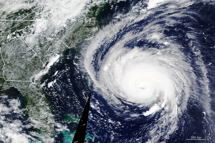
Friday, September 14th, 2018Florence nearing landfall with heavy surf and torrential rain
Friday, September 14th, 2018- Hurricane Florence has knocked out power to more than 285,000 homes and businesses statewide.
- Major structural damage has been reported to homes and businesses in Onslow County.
- Some 150 people were awaiting rescue in New Bern early Friday morning.
- A 10-foot storm surge was reported at Morehead City.
- About 12,000 people are in 126 evacuation shelters, state officials said.
NASA: How temperatures are changing the force of Florence
Thursday, September 13th, 2018As millions of people along the Atlantic Coast of the United States board up windows and evacuate before Hurricane Florence makes landfall, remote sensing researchers and forecasters are monitoring the environmental conditions fueling the powerful storm. They are assembling a suite of satellite images and data products that could aid storm preparedness and recovery efforts by federal and local partners.
As Florence approaches land, two key factors will help govern the severity of the storm: ocean temperatures and wind shear, the difference in wind speeds at upper and lower parts of a storm. Warm ocean water and low wind shear are required to sustain and intensify a hurricane.
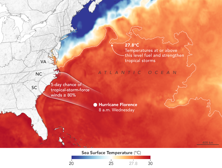
The map above shows sea surface temperatures on September 11, 2018. Meteorologists generally agree that sea surface temperatures (SSTs) should be above 27.8°C (82°F) to sustain and intensify hurricanes (although there are some exceptions). In Florence’s case, National Hurricane Center forecasters expect the storm to pass over water with temperatures well above that threshold. The data for the map were compiled by Coral Reef Watch, which blends observations from the Suomi NPP, MTSAT, Meteosat, and GOES satellites and computer models. Information about the storm track and winds come from the National Hurricane Center.
Florence will be traveling over water that is anomalously warm for this time of year, noted Marangelly Fuentes, a NASA atmospheric scientist who has been tracking the storm with models maintained by NASA’s Global Modeling and Assimilation Office (GMAO). As the storm approaches land, sea surface temperatures off of the Carolinas were between 0.5 and 1.5 degrees Celsius warmer than usual.
However, the warm coastal water is not the only reason that the Carolinas may be hit by one of the strongest hurricanes to ever make landfall at such a northerly latitude in this region.“While it is common to see storms this strong or even stronger over the ocean at this latitude,” said Gary Partyka, another atmospheric scientist with GMAO. “What set this situation apart was an unusually strong blocking high north of the storm that directed it towards the United States. Usually with storms at this latitude large-scale circulation patterns drive them to the north and east, well away from the coast.”
Forecasters have warned that life-threatening storm surges, catastrophic flooding, damaging winds, and dangerous rip currents will likely occur along the coastlines of North Carolina, South Carolina, and Virginia when the storm arrives late on September 13. There is growing concern that the presence of another atmospheric blocking ridge in the Mid-Atlantic region may cause the storm to stall and possibly move south and west toward Georgia, potentially extending the amount of time it remains over warm water and increasing the rainfall totals.
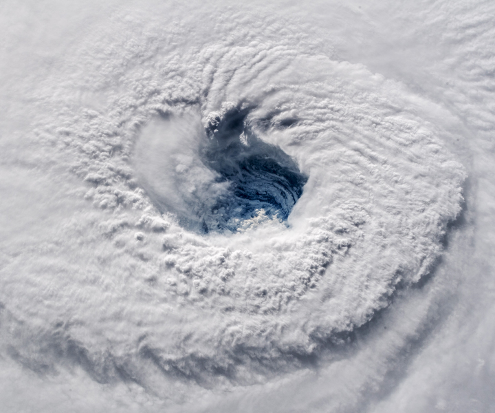
With forecasters expecting prodigious amounts of rain, NASA’s Disasters Program has mobilized a team that will use NASA sensors to monitor soil moisture, soil saturation, and rainfall rates. During and after the storm, this team will produce and disseminate information about where satellites observe floods and other effects of the storm. For more awesome, frightening views of Hurricane Florence, see this story.
NASA Earth Observatory image by Joshua Stevens, using sea surface temperature data from Coral Reef Watch and wind probabilities from the National Hurricane Center. Story by Adam Voiland.
FEMA & Florence: 9/12/18
Thursday, September 13th, 2018Situation Hurricane Florence expected to make landfall along the East Coast Friday
Preparations/Response FEMA HQ

• NRCC at Level I, 24/7 with all LNOs and ESFs
• National IMAT East-1 deployed to NC
• Region V & VIII IMATs deployed to DC to pre-stage
• Region I IMAT deployed to VA
• MERS assets deployed
• FSAs established at Ft A.P. Hill, VA and Martinsburg, WV
Region IV
• RRCC at Level II, 24/7
• LNOs and DCO/DCE deployed to NC and SC
• IMAT 1 deployed to NC
• IMAT 2 deployed to SC
• Regional HLT deployed to NHC North Carolina (FEMA-3401-EM-NC): • EOC at Full Activation;

Statewide State of Emergency declared
• Mandatory evacuations in effect for select areas; 50k evacuated out of 200k anticipated o Possible shortage of bus service due to World Equestrian Games
• US&R: Red IST, IN-TF1
• Shelters: 5 open with 258 occupants (ARC Midnight Shelter Count as of 5:46 a.m. EDT) South Carolina (FEMA-3400-EM-SC):
• EOC at Full Activation; Statewide State of Emergency declared
• Several public schools and government offices will be closed today
• Mandatory evacuations in effect for 6 counties, all other orders rescinded o Highway 521 (evacuation route) has construction projects and is down to one lane
• Shelters: 31 open with 1,385 occupants (ARC Midnight Shelter Count as of 5:46 a.m. EDT)
• US&R: FL-TF1&2, PA-TF1
• Tennessee EOC at Monitoring (to support EMAC requests)
Region III
• RRCC at Level II (day shift only) with all ESFs, DOD USCG, DHS IP, ARC; will go to Level III (night shift only) today
• LNO deployed to NRCC
• IMAT (Type III) deploying to MD
• IMAT (Type III) deployed to VA Virginia (FEMA-3403-EM-VA):
• EOC at Partial Activation; State of Emergency declared; National Guard activated
• Emergency Declaration approved September 11
• Mandatory evacuation in effect for Zone A (19 counties) in the Hampton Roads area
• Planning to open 3 state shelters by September 13 State Response
• MD EOC at Partial Activation; State of Emergency declared
• WV EOC at Full Activation
• DE EOC at Monitoring
• DC EOC at Monitoring; Mayor declared a state of emergency
• PA EOC returned to Normal Operations
Region II • NJ EOC at Monitor
USDA: Safeguarding Food, Pets, Livestock before Hurricane Florence
Thursday, September 13th, 2018USDA Urges Local Residents to Safeguard Food, Pets, Livestock before Hurricane Florence
USDA Office of Communications sent this bulletin at 09/12/2018 10:44 AM EDT
You are subscribed to USDA Office of Communications.
Release No. 0182.18
Contact: USDA Press
Email: press@oc.usda.gov
USDA Urges Local Residents to Safeguard Food, Pets, Livestock before Hurricane Florence
WASHINGTON, Sept. 12, 2018 – The U.S. Department of Agriculture (USDA) reminds rural communities, farmers and ranchers, families and small businesses in the path of Hurricane Florence that USDA has programs that provide assistance in the wake of disasters. USDA staff in the regional, state and county offices that stand ready and eager to help.
“If we know anything about American farmers, it’s that they can handle adversity. Even so, USDA is ready to help with the resources they need to be able to weather storms and recover from damages,” U.S. Secretary of Agriculture Sonny Perdue said. “As hurricanes approach, we have USDA personnel in counties throughout the nation, standing by to assist in any way possible.”
Hurricane Florence currently is forecast to make landfall Saturday morning near the border between North Carolina and South Carolina, and then travel westward through South Carolina.
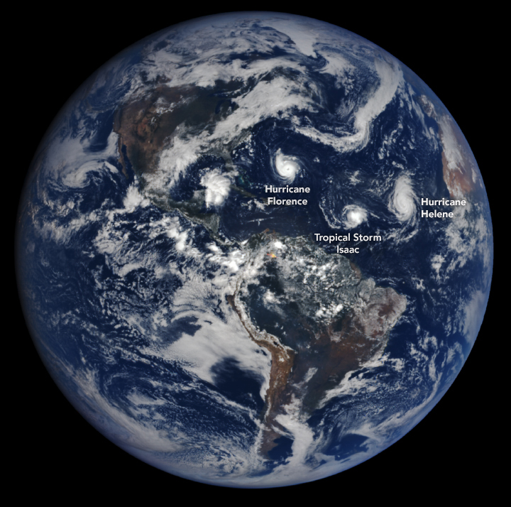
At the same time, Tropical Storm Isaac’s path may include Puerto Rico and the American Virgin Islands by Saturday morning. In the Pacific, Tropical Storm Olivia is forecast to move over the Hawaiian Islands late Tuesday into Wednesday, and Super Typhoon Mangkhut is moving away from Guam.
USDA encourages those in the path of the storms to take precautions to protect the safety of their food and animals.
Tips to best protect food safety before losing power:
- Keep appliance thermometers in both the refrigerator and the freezer to ensure temperatures remain food safe during a power outage. Safe temperatures are 40°F or lower in the refrigerator, 0°F or lower in the freezer.
- Freeze water in small plastic storage bags or containers prior to a storm. These containers are small enough to fit around the food in the refrigerator and freezer to help keep food cold.
- Freeze refrigerated items, such as leftovers, milk and fresh meat and poultry that you may not need immediately—this helps keep them at a safe temperature longer.
- Consider getting 50 pounds of dry or block ice if a lengthy power outage is possible. This amount of ice should keep a fully-stocked 18-cubic-feet freezer cold for two days.
- Group foods together in the freezer—this ‘igloo’ effect helps the food stay cold longer.
- Keep a few days’ worth of ready-to-eat foods that do not require cooking or cooling.
USDA’s Animal and Plant Health Inspection Service (APHIS) is urging everyone in the potential path of the hurricane to prepare now – not just for yourselves, but also for your pets and your livestock.
Protecting livestock during a disaster:
- Plan For Evacuation – Know how you will evacuate and where you will go. If it is not feasible to evacuate your livestock, be sure to provide adequate food and water that will last them until you can return, and a strong shelter.
- If you are planning to move livestock out of state, make sure to contact the State Veterinarian’s Office in the receiving state before you move any animals. You also may contact APHIS Veterinary Services state offices for information and assistance about protecting and moving livestock.
- Listen to Emergency Officials – Evacuate if asked to do so.
When major disasters strike, USDA has an emergency loan program that provides eligible farmers low-interest loans to help them recover from production and physical losses. USDA’s emergency loan program is triggered when a natural disaster is designated by the Secretary of Agriculture or a natural disaster or emergency is declared by the President under the Stafford Act. USDA also offers additional programs tailored to the needs of specific agricultural sectors to help producers weather the financial impacts of major disasters and rebuild their operations.
Helping producers weather financial impacts of disasters:
Livestock owners and contract growers who experience above normal livestock deaths due to specific weather events, as well as to disease or animal attacks, may qualify for assistance under USDA’s Livestock Indemnity Program.
Livestock, honeybee and farm-raised fish producers who suffer animal, feed, grazing and associated transportation cost losses due to an extreme weather event may qualify for assistance through USDA’s emergency assistance program tailored for their agricultural sectors. Producers who suffer losses to or are preventing from planting agricultural commodities not covered by federal crop insurance may be eligible for assistance under USDA’s Noninsured Crop Disaster Assistance Programs if the losses were due to natural disasters.
Helping operations recover after disasters:
USDA also can provide financial resources through its Environmental Quality Incentives Program to help with immediate needs and long-term support to help recover from natural disasters and conserve water resources.
Farmers and ranchers needing to rehabilitate farmland damaged by natural disasters can apply for assistance through USDA’s Emergency Conservation Program. USDA also has assistance available for eligible private forest landowners who need to restore forestland damaged by natural disasters through the Emergency Forest Restoration Program. USDA’s Emergency Watershed Protection Program also can help relieve imminent threats to life and property caused by flood, fires and other natural disasters that impair a watershed.
Orchardists and nursery tree growers may be eligible for assistance through USDA’s Tree Assistance Program to help replant or rehabilitate eligible trees, bushes, and vines damaged by natural disasters.
Producers with coverage through the Risk Management Agency (RMA) administered Federal crop insurance program should contact their crop insurance agent for issues regarding filing claims. Those who purchased crop insurance will be paid for covered losses. Producers should report crop damage within 72 hours of damage discovery and follow up in writing within 15 days. The Approved Insurance Providers (AIP), loss adjusters and agents are experienced and well trained in handling these types of events. As part of its commitment to delivering excellent customer service, RMA is working closely with AIPs that sell and service crop insurance policies to ensure enough loss adjusters will be available to process claims in the affected areas as quickly as possible. Please visit the RMA website – www.rma.usda.gov for more details.


![[Image of WPC QPF U.S. rainfall potential]](https://www.nhc.noaa.gov/storm_graphics/AT06/refresh/AL0618WPCQPF+gif/093211WPCQPF_sm.gif)


