Archive for the ‘Volcano’ Category
White Island: SAS soldiers recover six bodies while divers hunt for missing two Kiwi tour guides
Friday, December 13th, 2019“……
- New Zealand Defence Force have recovered six of the eight bodies of the White Island volcano victims Friday
- Two bodies could not be found because they are under water but police say they will continue the search
- Divers have been sent out to search the waters after one of the bodies was spotted in the ocean on Tuesday
- Mission started at first light despite increased chance volcano would erupt again, with high alert being issued
- Six Australians and two New Zealanders were believed to be on island when the deadly eruption happened
- Relieved families were seen hugging, crying and clapping when told bodies had been removed from island….”
After a volcanic island in New Zealand erupted, aerial searches have revealed “no signs of life” since the eruption.
Monday, December 9th, 2019A volcano on the Italian island of Stromboli erupted on Wednesday, unleashing a dramatic plume of smoke in its second explosion in less than two months.
Friday, August 30th, 2019August 27, 1883: The Krakatoa explosions threw five cubic miles of earth 50 miles into the air, created 120-foot tsunamis and killed 36,000 people.
Tuesday, August 27th, 20198/24/79AD: Mount Vesuvius erupts in southern Italy, devastating the prosperous Roman cities of Pompeii and Herculaneum and killing thousands.
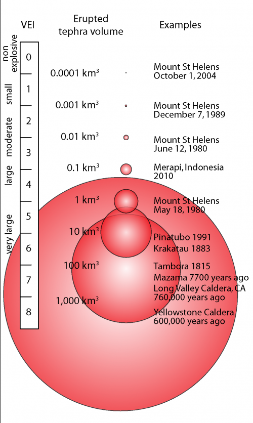
Saturday, August 24th, 2019The Volcanic Explosivity Index (VEI) & The Threat of Supervolcanoes like in Yellowstone
Friday, August 23rd, 2019California: Supervolcanic eruptions may be a future possibility
Wednesday, July 10th, 2019‘…….“The potential for damaging earthquakes, landslides, floods, tsunamis and wildfires is widely recognized in California,” another recent USGS report reads. “The same cannot be said for volcanic eruptions, even though they occur in the state about as frequently as the largest earthquakes on the San Andreas Fault.”
Of the state’s eight volcanoes, seven have been found to sit above “active” magma chambers.
Disturbingly, it finds some 200,000 people are classified as “at-risk” if an eruption was to occur. And it argues there is a 16 percent chance of such an event within the next 30 years.
Like the fault-line studies, geologists have pulled clues from California’s landscape to determine volcanic activity over the past 5,000 years.
It’s found five volcanoes – Mount Shasta, Medicine Lake, Lassen, Long Valley and Salton Buttes – have erupted during the past 3000 years. Clear Lake Volcanic Field near San Francisco – while rated as potentially of very high risk – hasn’t blown for longer…….’
Raikoke Volcano on the Kuril Islands rarely erupts. The small, oval-shaped island most recently exploded in 1924 and in 1778. The dormant period ended around 4:00 a.m. local time on June 22, 2019
Thursday, June 27th, 2019A thick plume of volcanic ash rises above the dense cloud cover in this close-up #Himawari8 view of the #Raikoke volcano's eruption. This was the volcano's first eruption since 1924. More imagery: https://t.co/wIF4txQIDW pic.twitter.com/vZExba5QDZ
— NOAA Satellites (@NOAASatellites) June 24, 2019
Unlike some of its perpetually active neighbors on the Kamchatka Peninsula, Raikoke Volcano on the Kuril Islands rarely erupts. The small, oval-shaped island most recently exploded in 1924 and in 1778.
The dormant period ended around 4:00 a.m. local time on June 22, 2019, when a vast plume of ash and volcanic gases shot up from its 700-meter-wide crater. Several satellites—as well as astronauts on the International Space Station—observed as a thick plume rose and then streamed east as it was pulled into the circulation of a storm in the North Pacific.
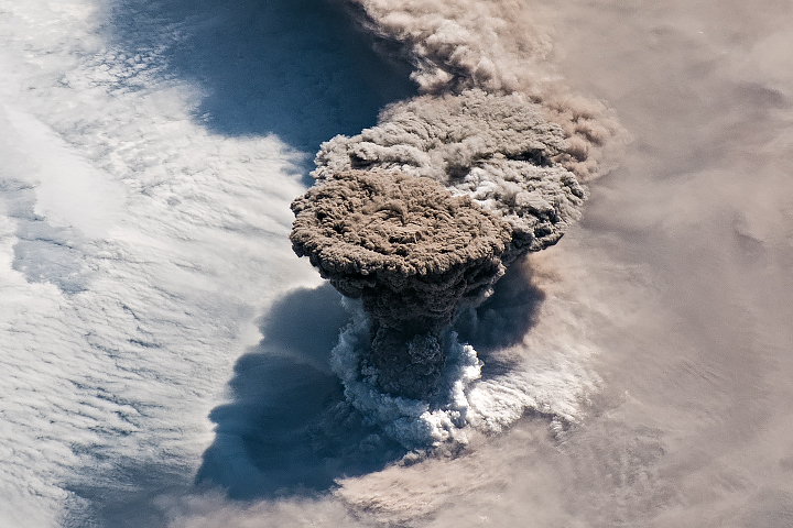
On the morning of June 22, astronauts shot a photograph (above) of the volcanic plume rising in a narrow column and then spreading out in a part of the plume known as the umbrella region. That is the area where the density of the plume and the surrounding air equalize and the plume stops rising. The ring of clouds at the base of the column appears to be water vapor.
“What a spectacular image. It reminds me of the classic Sarychev Peak astronaut photograph of an eruption in the Kuriles from about ten years ago,” said Simon Carn, a volcanologist at Michigan Tech. “The ring of white puffy clouds at the base of the column might be a sign of ambient air being drawn into the column and the condensation of water vapor. Or it could be a rising plume from interaction between magma and seawater because Raikoke is a small island and flows likely entered the water.”
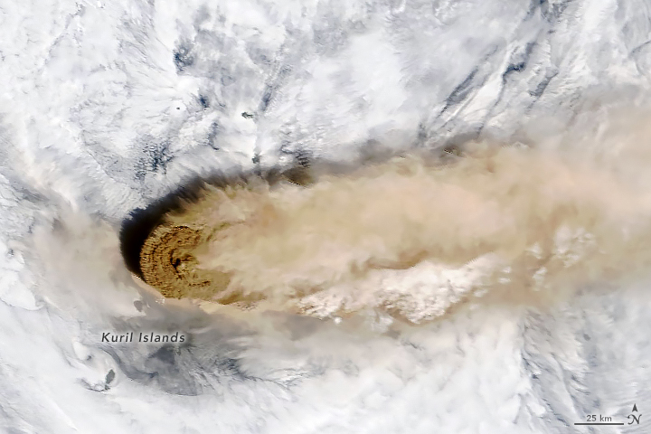
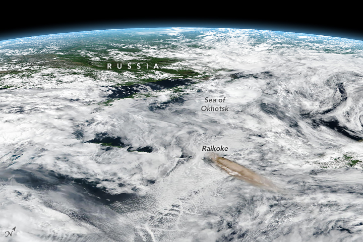
The Moderate Resolution Imaging Spectroradiometer (MODIS) on NASA’s Terra satellite acquired the second image on the morning of June 22. At the time, the most concentrated ash was on the western edge of the plume, above Raikoke. The third image, an oblique, composite view based on data from the Visible Infrared Imaging Radiometer Suite (VIIRS) on Suomi NPP, shows the plume a few hours later. After an initial surge of activity that included several distinct explosive pulses, activity subsided and strong winds spread the ash across the Pacific. By the next day, just a faint remnant of the ash remained visible to MODIS.
Since ash contains sharp fragments of rock and volcanic glass, it poses a serious hazard to aircraft. The Tokyo and Anchorage Volcanic Ash Advisory Centers have been tracking the plume closely and have issued several notes to aviators indicating that ash had reached an altitude of 13 kilometers (8 miles). Meanwhile, data from the CALIPSO satellite indicate that parts of the plume may have reached 17 kilometers (10 miles).
In addition to tracking ash, satellite sensors can also track the movements of volcanic gases. In this case, Raikoke produced a concentrated plume of sulfur dioxide (SO2) that separated from the ash and swirled throughout the North Pacific as the plume interacted with the storm.
“Radiosonde data from the region indicate a tropopause altitude of about 11 kilometers, so altitudes of 13 to 17 kilometers suggest that the eruption cloud is mostly in the stratosphere,” said Carn. “The persistence of large SO2 amounts over the last two days also indicates stratospheric injection.”
Volcanologists watch closely for plumes that reach the stratosphere because they tend to stay aloft for longer than those that remain within the troposphere. That is why plumes that reaches the stratosphere typically have the greatest effects on aviation and climate.
NASA Earth Observatory images by Joshua Stevens, using MODIS and VIIRS data from NASA EOSDIS/LANCE and GIBS/Worldview and the Suomi National Polar-orbiting Partnership. Astronaut photograph ISS059-E-119250 was acquired on June 22, 2019, with a Nikon D5 digital camera and is provided by the ISS Crew Earth Observations Facility and the Earth Science and Remote Sensing Unit, Johnson Space Center. The image was taken by a member of the Expedition 59 crew. The image has been cropped and enhanced to improve contrast, and lens artifacts have been removed. Story by Adam Voiland, with information from Erik Klemetti (Denison University), Simon Carn (Michigan Tech), and Andrew Prata (Barcelona Supercomputing Center).


