Archive for the ‘Volcano’ Category
Volcán de Fuego in Guatemala: “The volcano would grumble and make noise. We never thought it would take our things and leave us with nothing.”
Sunday, June 24th, 2018https://www.youtube.com/watch?v=dwT9yo1gRi8
https://www.youtube.com/watch?v=sWuCVdaRbBw
https://www.youtube.com/watch?v=FI3pEaHmya4
Kilauea: Current Situation (USGS HVO Status Report, June 18)
Monday, June 18th, 2018Current Situation (USGS HVO Status Report, June 18)
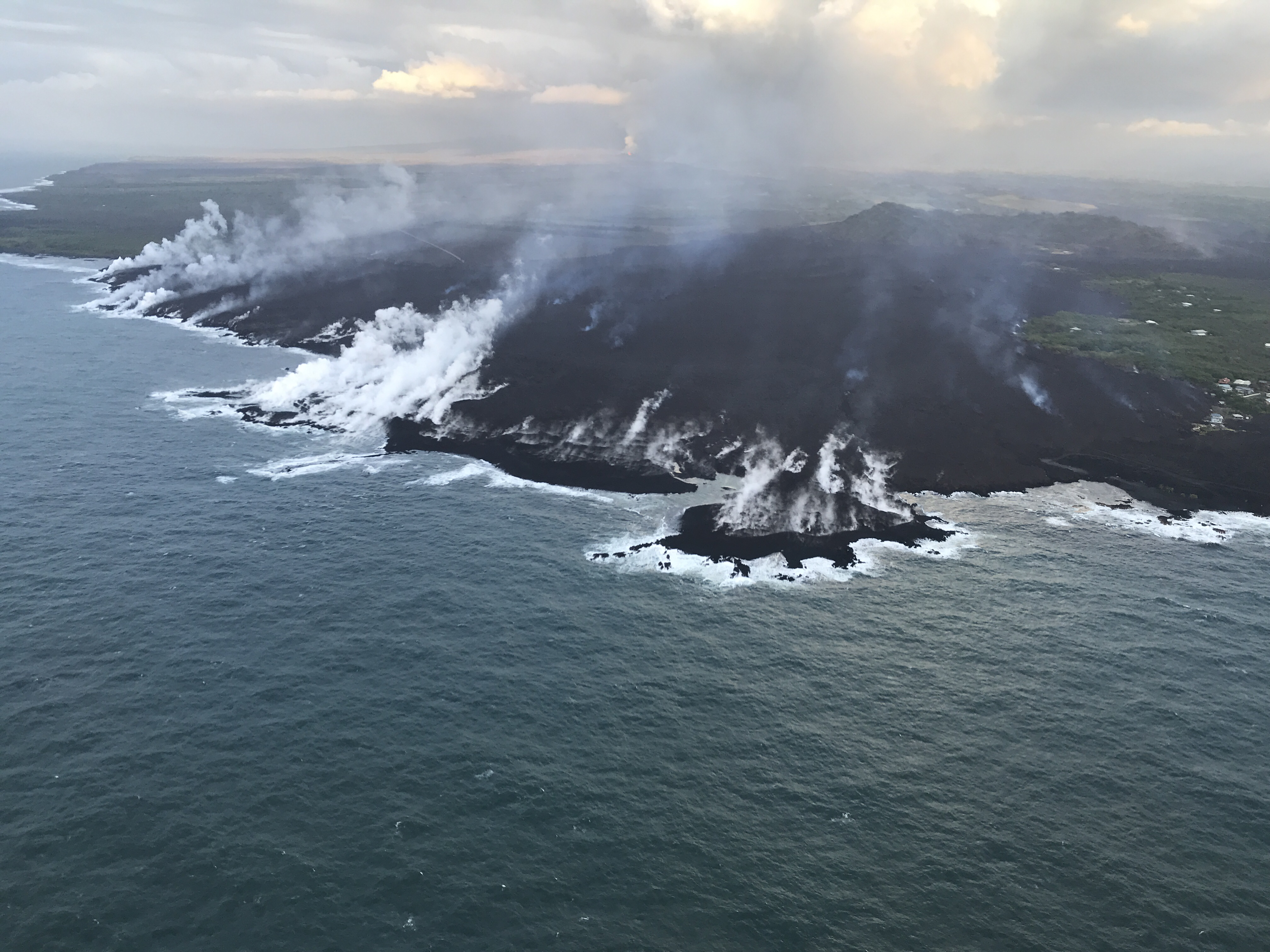
Lower East Rift Zone: Lava from Fissure 8 is flowing to the ocean, but could break out of channels and threaten the community of Nanawale (675 homes, pop. 1,384).
Ocean entry remained fairly broad with laze blown onshore. Lightweight volcanic glass continues to fall downwind; high winds may waft lighter particles to greater distances. Summit: Seismicity continues to increase, with a series of M5+ earthquakes likely caused by explosive volcanic activity over the last 48 hours. Sulfur dioxide emissions are lower than they have been, but remain at dangerous levels.
https://www.youtube.com/watch?v=A–zLc6EqrU
Impacts (DR-4366-HI SITREP, June 16)
• Injuries / Fatalities: 4 injuries / 0 fatalities (NC since May 22)
• Evacuations (Residents): 2,800 (mandatory), 150 (voluntary) (NC since June 3) • Shelters: 3 open / 114 (-6) occupants (ARC Midnight Shelter Count, June 18)
• Damage: 455 (+135) structures destroyed (192 homes)
• Power: 935 (-79) customers without power
• Transportation: 474 (-1) structures isolated by lava flows
Kīlauea Eruption – Hawai’i County, HI
Alert Level: WARNING Color Code: RED
State / Local Response
• HI EOC at Partial Activation
FEMA Response
• IA approved on June 14; DRC opened on June 15
• Region IX RWC at Steady State
NASA: Volcán de Fuego
Thursday, June 14th, 2018Fuego in Guatemala is one of Central America’s most active volcanoes. For years, the towering Volcán de Fuego has puffed continuously, punctuated by occasional episodes of explosive activity, big ash plumes, lava flows, and avalanche-like debris slides known as pyroclastic flows.
Just before noon on June 3, 2018, the volcano produced an explosive eruption that sent ash billowing thousands of meters into the air. A deadly mixture of ash, rock fragments, and hot gases rushed down ravines and stream channels on the sides of the volcano. Since these pyroclastic flows often move at speeds of greater than 80 kilometers (50 miles) per hour, they easily topple trees, homes, or anything else in their path. According to news reports, more than two dozen people were killed. As a precautionary measure, thousands of other people have been evacuated.
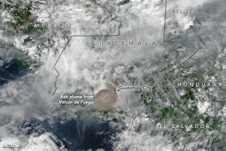
The Visible Infrared Imaging Radiometer Suite (VIIRS) on Suomi NPP acquired this image of the ash plume at 1 p.m. local time (19:00 Universal Time) on June 3, 2018, after the ash (brown) had punched through a deck of clouds. A report from the Washington Volcanic Ash Advisory Center estimated the plume’s maximum height at 15 kilometers (9 miles). Imagery from a geostationary satellite showed winds blowing the plume to the east. The eruption deposited ash on several communities surrounding the volcano, including Guatemala City, which is 70 kilometers (40 miles) to the east.
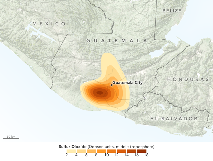
In addition to ash, the plume contains gaseous components invisible to the human eye, including sulfur dioxide (SO2). The gas can affect human health—irritating the nose and throat when breathed in—and reacts with water vapor to produce acid rain. Sulfur dioxide also can react in the atmosphere to form aerosol particles, which can contribute to outbreaks of haze and sometimes cool the climate.
Satellite sensors such as the Atmospheric Infrared Sounder (AIRS) on the Aqua satellite and the Ozone Mapping Profiler Suite (OMPS) on Suomi NPP make frequent observations of sulfur dioxide. The map above shows concentrations of sulfur dioxide in the middle troposphere at an altitude of 8 kilometers (5 miles) as detected by OMPS on June 3.
Upon seeing data collected by AIRS several hours after the eruption that showed high levels of sulfur dioxide in the upper troposphere, Michigan Tech volcanologist Simon Carn tweeted that this appeared to be the “highest sulfur dioxide loading measured in a Fuego eruption in the satellite era.”
-
References
- Discover (2018, June 4) Rocky Planet: Deadliest Eruption of 2018. Accessed June 4, 2018.
- NASA Global Sulfur Dioxide Monitoring Home Page. Accessed June 4, 2018.
- Smithsonian Institution Global Volcanism Program (2018) Fuego. Accessed June 4, 2018.
- The New York Times (2018, June 4) Guatemala’s Fuego Volcano Erupts, Killing at Least 33. Accessed June 4, 2018.
- U.S. Geological Survey Pyroclastic flows move fast and destroy everything in their path. Accessed June 4, 2018.
- Volcano Discovery (2018, June 4) Fuego volcano news & eruption update. Accessed June 4, 2018.
NASA Earth Observatory images by Joshua Stevens, using VIIRS data from the Suomi National Polar-orbiting Partnership and OMPS data from the Goddard Earth Sciences Data and Information Services Center (GES DISC). Story by Adam Voiland.
- Instrument(s):
- Suomi NPP – VIIRS
- Suomi NPP – OMPS
FEMA Sit Rep; 6-11-18 re Kilauea
Monday, June 11th, 2018Eruptions continue from the lower East Rift Zone fissure system.
Minor flows overtopping the channel levees have been observed. The ocean entry area continues to produce laze.
Volcanic gas emissions remain high.
Impacts (FEMA-4366-DR-HI COP, 11:00 p.m. EDT June 7)
Injuries / Fatalities: 4 injuries / 0 fatalities
• Evacuations: Mandatory for 2,800 residents; an additional 150 residents under voluntary evacuation in Papaya Farms Road and Waa Waa
• 475 structures isolated but potentially not impacted, due to roads being cut off
• Shelters: 3 shelters open with 131 occupants (ARC Midnight Shelter Count, June 11)
• Damage: 320 structures destroyed (130 homes)
• Power: 856 customers without power; Puna Geothermal Venture plant not accessible except by off-road vehicles and air transport; substation destroyed
• Transportation: FAA Temporary Flight Restrictions extended through August 31 State / Local Response
• HI EOC at Partial Activation; Governor declared a State of Emergency
FEMA Response
• Interim Operating Facility (IOF) established with N-IMAT East 1, a portion of N-IMAT East 2, and Bothell MERS supporting
USGS summary on Kilauea
Sunday, June 10th, 2018Kīlauea is the youngest and southeastern most volcano on the Island of Hawai‘i. Topographically Kīlauea appears as only a bulge on the southeastern flank of Mauna Loa, and so for many years Kīlauea was thought to be a mere satellite of its giant neighbor, not a separate volcano. However, research over the past few decades shows clearly that Kīlauea has its own magma-plumbing system, extending to the surface from more than 60 km deep in the earth.
In fact, the summit of Kīlauea lies on a curving line of volcanoes that includes Mauna Kea and Kohala and excludes Mauna Loa. In other words, Kīlauea is to Mauna Kea as Lō‘ihi is to Mauna Loa. Hawaiians used the word Kīlauea only for the summit caldera, but earth scientists and, over time, popular usage have extended the name to include the entire volcano.
Kīlauea is the home of Pele, the Hawaiian volcano goddess. Hawaiian chants and oral traditions tell in veiled form of many eruptions fomented by an angry Pele before the first European, the missionary Rev. William Ellis, saw the summit in 1823. The caldera was the site of nearly continuous activity during the 19th century and the early part of the 20th century. Since 1952 there have been 34 eruptions, and since January 1983 eruptive activity has been continuous along the East Rift Zone. In March 2008, a vent also opened in Halema‘uma‘u Crater at the volcano’s summit. The summit crater hosts an active lava pond and a vigorous gas plume. Kīlauea ranks among the world’s most active volcanoes and may even top the list.
ocation: Island of Hawai‘i
Latitude: 19.421° N
Longitude: 155.287° W
Elevation: 1,222 (m) 4,009 (f)
Volcano type: Shield
Composition: Basalt
Most recent eruption: Current
Nearby towns: Volcano, Pāhoa, Kalapana, Mountain View
Threat Potential: Very High *

NASA captures deadly eruption in Guatemala
Sunday, June 10th, 2018
Fuego in Guatemala is one of Central America’s most active volcanoes. For years, the towering Volcán de Fuego has puffed continuously, punctuated by occasional episodes of explosive activity, big ash plumes, lava flows, and avalanche-like debris slides known as pyroclastic flows.
Just before noon on June 3, 2018, the volcano produced an explosive eruption that sent ash billowing thousands of meters into the air. A deadly mixture of ash, rock fragments, and hot gases rushed down ravines and stream channels on the sides of the volcano. Since these pyroclastic flows often move at speeds of greater than 80 kilometers (50 miles) per hour, they easily topple trees, homes, or anything else in their path. According to news reports, more than two dozen people were killed. As a precautionary measure, thousands of other people have been evacuated.
The Visible Infrared Imaging Radiometer Suite (VIIRS) on Suomi NPP acquired this image of the ash plume at 1 p.m. local time (19:00 Universal Time) on June 3, 2018, after the ash (brown) had punched through a deck of clouds. A report from the Washington Volcanic Ash Advisory Center estimated the plume’s maximum height at 15 kilometers (9 miles). Imagery from a geostationary satellite showed winds blowing the plume to the east. The eruption deposited ash on several communities surrounding the volcano, including Guatemala City, which is 70 kilometers (40 miles) to the east.
In addition to ash, the plume contains gaseous components invisible to the human eye, including sulfur dioxide (SO2). The gas can affect human health—irritating the nose and throat when breathed in—and reacts with water vapor to produce acid rain. Sulfur dioxide also can react in the atmosphere to form aerosol particles, which can contribute to outbreaks of haze and sometimes cool the climate.
Satellite sensors such as the Atmospheric Infrared Sounder (AIRS) on the Aqua satellite and the Ozone Mapping Profiler Suite (OMPS) on Suomi NPP make frequent observations of sulfur dioxide. The map above shows concentrations of sulfur dioxide in the middle troposphere at an altitude of 8 kilometers (5 miles) as detected by OMPS on June 3.
Upon seeing data collected by AIRS several hours after the eruption that showed high levels of sulfur dioxide in the upper troposphere, Michigan Tech volcanologist Simon Carn tweeted that this appeared to be the “highest sulfur dioxide loading measured in a Fuego eruption in the satellite era.”
-
References
- Discover (2018, June 4) Rocky Planet: Deadliest Eruption of 2018. Accessed June 4, 2018.
- NASA Global Sulfur Dioxide Monitoring Home Page. Accessed June 4, 2018.
- Smithsonian Institution Global Volcanism Program (2018) Fuego. Accessed June 4, 2018.
- The New York Times (2018, June 4) Guatemala’s Fuego Volcano Erupts, Killing at Least 33. Accessed June 4, 2018.
- U.S. Geological Survey Pyroclastic flows move fast and destroy everything in their path. Accessed June 4, 2018.
- Volcano Discovery (2018, June 4) Fuego volcano news & eruption update. Accessed June 4, 2018.
NASA Earth Observatory images by Joshua Stevens, using VIIRS data from the Suomi National Polar-orbiting Partnership and OMPS data from the Goddard Earth Sciences Data and Information Services Center (GES DISC). Story by Adam Voiland.
- Instrument(s):
- Suomi NPP – VIIRS
- Suomi NPP – OMPS
Kilauea: Hundreds of homes in the Kapoho Beach Lots and Vacationland communities have been destroyed.
Thursday, June 7th, 2018https://www.youtube.com/watch?v=9CcQtmx-g0s
HAWAIIAN VOLCANO OBSERVATORY STATUS REPORT
U.S. Geological Survey
Wednesday, June 6, 2018, 2:34 PM HST (Thursday, June 7, 2018, 00:34 UTC)
KILAUEA VOLCANO (VNUM #332010)
19°25’16” N 155°17’13” W, Summit Elevation 4091 ft (1247 m)
Current Volcano Alert Level: WARNING
Current Aviation Color Code: RED

Kīlauea Volcano Lower East Rift Zone
Vigorous eruption of lava continues from the lower East Rift Zone (LERZ) fissure system in the area of Leilani Estates.
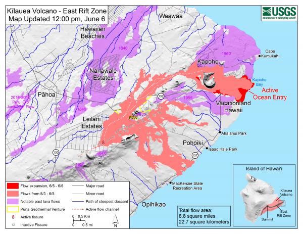
This morning, lava fountaining at Fissure 8 continued to reach heights of 150-180 feet, feeding a stable channel to the east to the ocean entry in the Kapoho Bay area. Lava is entering the ocean in the Vacationland subdivision. Vacationland has been completely covered by lava, and overnight the flow expanded north by 100 m within Kapoho Beach Lots. The lava delta that formed at Kapoho Bay extended slightly overnight.
The northern lobe of the Fissure 8 flow shows no signs of activity this morning, and there is only wispy smoke at the flow front. No other fissures are active.
Pele’s hair and other lightweight volcanic glass from high fountaining of Fissure 8 are falling downwind of the fissure and accumulating on the ground within Leilani Estates. Winds may waft lighter particles to greater distances. Residents are urged to minimize exposure to these volcanic particles, which can cause skin and eye irritation similar to volcanic ash.
The most recent map of lava flows can be found at https://volcanoes.usgs.gov/volcanoes/kilauea/multimedia_maps.html
HVO field crews are on site tracking the fountains, lava flows, and spattering from multiple fissures as conditions allow and are reporting information to Hawaii County Civil Defense.
Volcanic gas emissions remain very high from the fissure eruptions. For the next few days wind conditions may bring vog not only to the south and west sides of the Island of Hawaii, but also the island’s interior.
The ocean entry is a hazardous area. Hazards include walking on uneven, glassy lava flow surfaces and around unstable, vertical sea cliffs. Venturing too close to an ocean entry on land or the ocean exposes you to flying debris from sudden explosive interaction between lava and water. Also, the lava delta is unstable because it is built on unconsolidated lava fragments and sand. This loose material can easily be eroded away by surf, causing the new land to become unsupported and slide into the sea. In several instances, such collapses have also incorporated parts of the older sea cliff. Additionally, the interaction of lava with the ocean creates “laze”, a corrosive seawater plume laden with hydrochloric acid and fine volcanic particles that can irritate the skin, eyes, and lungs.
Magma continues to be supplied to the lower East Rift Zone. Earthquake locations have not moved farther downrift in the past few days and the number of located earthquakes remains low. Seismicity remains relatively low with numerous small magnitude earthquakes and low amplitude background tremor.
Additional ground cracking and outbreaks of lava in the area of the active fissures are possible. Residents downslope of the region of fissures should heed all Hawaii County Civil Defense messages and warnings.
USGS/HVO continues to monitor the lower East Rift Zone activity 24/7 in coordination with Hawaii County Civil Defense.
Kīlauea Volcano Summit
Earthquake activity is increasing after Tuesday morning’s small explosion, with ten M3+ earthquakes since 5 am in the Kīlauea summit area. This pattern suggests that more felt earthquakes and a small explosion are likely within the next few hours. Monitoring data indicate that subsidence at the summit and inward slumping of the rim and walls of Halema`uma`u continues.
Over the last week, sulfur dioxide emissions from the volcano’s summit have decreased, but emission rates remain high enough to impact air quality in downwind regions. Additional bursts of gas released with intermittent explosive activity are also transported downwind and may temporarily affect air quality as well.
For forecasts of where ash would fall under forecast wind conditions, please consult the Ash3D model output here: https://volcanoes.usgs.gov/observatories/hvo/activity_2018.html
Information on volcanic ash hazards and how to prepare for ash fall maybe found at http://www.ivhhn.org/information#ash (health impacts) OR https://volcanoes.usgs.gov/volcanic_ash/ (other impacts).
MORE INFORMATION
Activity Summary also available by phone: (808) 967-8862
Subscribe to these messages: https://volcanoes.usgs.gov/vns2/
Webcam images: https://volcanoes.usgs.gov/volcanoes/kilauea/multimedia_webcams.html
Photos/Video: https://volcanoes.usgs.gov/volcanoes/kilauea/multimedia_chronology.html
Lava Flow Maps: https://volcanoes.usgs.gov/volcanoes/kilauea/multimedia_maps.html
Definitions of terms used in update: https://volcanoes.usgs.gov/volcanoes/kilauea/extra/definitions.pdf
Overview of Kīlauea summit (Halemaʻumaʻu) and East Rift Zone (Puʻu ʻŌʻō ) eruptions:
https://volcanoes.usgs.gov/volcanoes/kilauea/extra/background.pdf
Summary of volcanic hazards from Kīlauea eruptions:
https://volcanoes.usgs.gov/volcanoes/kilauea/extra/hazards.pdf
Recent Earthquakes in Hawai’i (map and list):
https://volcanoes.usgs.gov/hvo/earthquakes/
Explanation of Volcano Alert Levels and Aviation Color Codes:
https://volcanoes.usgs.gov/activity/alertsystem/index.php
https://pubs.usgs.gov/fs/2006/3139/
CONTACT INFORMATION:
askHVO@usgs.gov
The Hawaiian Volcano Observatory is one of five volcano observatories within the U.S. Geological Survey and is responsible for monitoring volcanoes and earthquakes in Hawai`i.


