Archive for the ‘Weather’ Category
La Niña Makes a Quiet Return
Saturday, December 30th, 2017La Niña is the cooler sister to El Niño. La Niña draws cool water up from the depths of the eastern Pacific, energizes the easterly winds, and pushes warm surface water back toward Asia. (Note the ripples of warm water moving west across the equator.) In turn, global atmospheric circulation and jet streams shift with the changing heat and moisture supply from the vast Pacific Ocean.
During La Niña events, the weather tends to grow warmer and drier across the southern portion of North America, from California to Florida. Cooler than normal temperatures usually prevail across western Canada, Alaska, and the U.S. Pacific Northwest. Over the central and eastern Pacific Ocean, clouds and rainfall become more sporadic, while rainfall tends to increase dramatically in Indonesia and the western Pacific. Weather conditions in late 2017 seemed to fit with that pattern.
Snow wreaks havoc in Northern Ireland
Friday, December 8th, 2017“…..Snow showers will continue in Northern Ireland on Friday night, with some of them heavy in the north and east.
Snow fell across many parts of NI earlier, resulting in travel disruption. A number of schools closed, as did Belfast Zoo.
Translink has said it has had to terminate some buses along parts of their routes on Friday evening.
There are also a number of delays and cancellations to flights at both the International and Belfast City Airport…..”
https://www.youtube.com/watch?v=TcYjXccLjD4
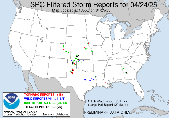
Severe thunderstorms capable of large hail, damaging winds, and a few tornadoes, will be possible from parts of the mid Mississippi Valley east-northeastward into the lower Great Lakes this afternoon into tonight. Heavy rain and local flooding are also possible. Meanwhile, heavy snow will occur in the Cascades and northern and central Rockies.
Sunday, November 5th, 2017
| Filtered Tornado Reports (CSV) (Raw Tornado CSV)(?) | |||||||
|---|---|---|---|---|---|---|---|
| Time | Location | County | State | Lat | Lon | Comments | |
| 1840 | 4 NW COMO | JAY | IN | 4042 | 8515 | BUILDING DAMAGE. SCATTERED DEBRIS IN ALL DIRECTIONS ACROSS FIELDS. ROOF GONE FROM A BARN. (IWX) | |
| 1850 | 2 W COLLEGE CORNER | JAY | IN | 4041 | 8501 | SMALL BARN DESTROYED. (IWX) | |
| 1857 | 1 ESE BOUNDARY CITY | JAY | IN | 4034 | 8490 | RESIDENTS REPORTED A SMALL TORNADO TOUCHDOWN. LOTS OF DAMAGE REPORTED. PICTURES ARE BEING TAKEN. (IWX) | |
| 1857 | CONVERSE | BLACKFORD | IN | 4039 | 8524 | LOCATION CORRECTION. RESIDENTS REPORTED A SMALL TORNADO TOUCHDOWN; BARN GONE … MISSING ROOF ON HOUSE. (IWX) | |
| 1918 | 4 WSW CASTALIA | SANDUSKY | OH | 4139 | 8288 | SANDUSKY COUNTY SHERIFF REPORTED A BEDROOM DESTROYED AT A RESIDENCE OFF STATE ROUTE 412 WEST OF THE SANDUSKY-ERIE COUNTY LINE. TREES ALSO DOWNED NEARBY. (CLE) | |
| 1938 | 1 ESE BLOOMINGVILLE | ERIE | OH | 4135 | 8270 | SPOTTER REPORTS DAMAGE TO HOMES AND POWERLINES NEAR MASON ROAD IN PERKINS TOWNSHIP. (CLE) | |
| 1940 | E CELINA | MERCER | OH | 4055 | 8457 | *** 8 INJ *** EAST SIDE OF TOWN IN THE BUSINESS DISTRICT. ESTIMATED EF1 APPROXIMATELY 200 YARDS WIDE. SEVERAL BUSINESSES DAMAGED … SOME WITH ROOFS OFF. OVER 100 VEHICL (ILN) | |
Nine dead & nearly 20 others were taken from the rig hospitalized in dire condition, many with extreme dehydration and heatstroke
Monday, July 24th, 2017- Thirty were hospitalized in all
- 17 of those rescued were being treated for injuries that were considered life-threatening


