Archive for the ‘Fires/Wildfires’ Category
At more than 443 sq. miles, the Mendocino Complex fire becomes largest wildfire in California history
Tuesday, August 7th, 2018The Mendocino Complex Fire has charred more than 254,000 acres, making it the fifth largest blaze in California’s history.
Sunday, August 5th, 2018NASA: Wildfires Blanket Western States With Smoke
Friday, August 3rd, 2018
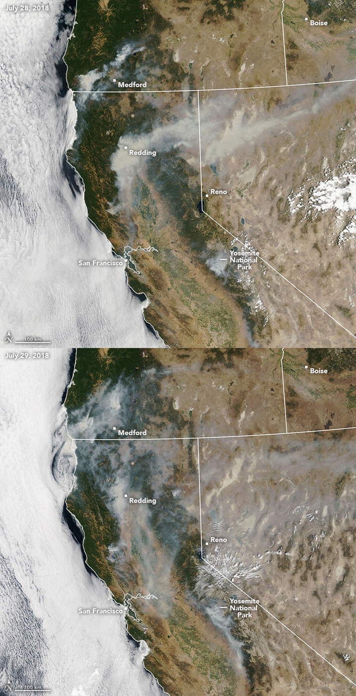
The 2018 wildfire season in North America is well under way, with blazes having burned more acres than average through the end of July. Earlier in the summer, satellite images showed smoke and burn scars from fires in western states including California and Colorado. As the calendar turns to August, smoke is now streaming from fires in nearly every western state.
The Moderate Resolution Imaging Spectroradiometer (MODIS) on NASA’s Terra and Aqua satellites acquired these natural-color images on July 28 and 29. The animation shows how winds can make smoke plumes vary daily in direction and distance from their source.
A notable amount of the smoke stems from the Carr Fire, which is burning in Shasta County near Redding, California. The fire ignited on July 23 amid warm, dry conditions. By July 30, it had burned 98,724 acres and was just 20 percent contained, according to Cal Fire. News reports noted that shifting, gusty winds and a lack of rain in the forecast could worsen the situation.
Other states also contributed to the smoke pall over the West. According to the National Interagency Fire Center, 98 large active fires were burning across the United States on July 30, having consumed 1.2 million acres. States with the largest fires counts included Oregon (16), Alaska (15), Arizona (10), Colorado (13), and California (9).
Most areas of burning land are not directly visible in satellite imagery, obscured from view by smoke and clouds. The Perry Fire in Nevada is an exception; check out these Landsat images to see how the fire advanced over the span of a day.
NASA Earth Observatory images by Lauren Dauphin, using MODIS data from LANCE/EOSDIS Rapid Response. Story by Kathryn Hansen.
Carr Fire: One hospital evacuated; neonatal patients evacuated from another & 8 intermediate care facilities fully evacuated
Tuesday, July 31st, 2018Carr Fire – Shasta County, CA
Current Situation
• Fire continues to spread in the north and south; progression into the city of Redding has slowed. Shifting winds in timber fuels combine with steep drainages below control lines are contributing to spot fires crossing lines.
• Fatalities / Injuries: 6 confirmed / 0
• Acres burned: 104k (+8,632); Containment: 23% (+6) • Structures / Homes: o Threatened: 4,012 homes (-966), 22 multiple residences, 12 commercial o Damaged: 209 structures (+44); 165 homes (+22) o Destroyed: 1,132 structures (+258); 818 homes (+161)
• Evacuations: Mandatory for approximately 35k (-4k) people
• Hospitals: o One hospital evacuated; neo-natal patients evacuated from another o Eight intermediate care facilities fully evacuated
• Shelters / Occupants: 5 open / 281 (-156) occupants (ARC Midnight Shelter Count)
• Infrastructure: o Power outages: 3k customers*; Gas outages: 250 customers o Power grid is stable with excess capacity o Trinity power plant continues operation; full grid restoration pending inspection
Carr Fire – Shasta County, CA
State / Local Response
• CA EOC at Full Activation; Southern REOC at Partial Activation (day shift only)
• Governor declared a State of Emergency for six counties
FEMA Response
• Emergency Declaration FEMA-3398-EM-CA approved July 28, 2018
• FMAG FEMA-5259-FM-CA approved July 23, 2018
• Region IX: o RWC at Steady State, continues to monitor o IMAT-2 deployed to CA EOC (supported by ESFs 1, 3, 4, 6, 7, 8, 12, & DCO) o LNOs deployed to CA EOC and Shasta County EOC • Staging Area established at Redding Municipal Airport o ISB Team and Cache deployed o Commodities prepositioned: Cots, blankets, meals, and water
The Carr Fire rampaging in the area of Redding has destroyed 818 homes, 311 outbuildings, killed 2 firefightera and 4 civilians.
Tuesday, July 31st, 2018- Now the ninth most destructive in the state’s history.
- More than 27,000 people remain evacuated because of the blaze, which has burned for more than a week.
The monstrous Carr Fire continues to grow Sunday & 7 persons are still missing
Sunday, July 29th, 2018Greece: The Greek Fire Brigade said the death toll is up to at least 80 people
Thursday, July 26th, 2018Death toll from Greek wildfires up to at least 49.
Tuesday, July 24th, 2018- The bodies of more than 20 people huddled closely together near a beach northeast of Athens.
- Greece seeking international help
- Fires on either side of Athens left lines of cars torched, charred farms and forests, and sent hundreds of people racing to beaches to be evacuated by navy vessels, yachts and fishing boats.


