Archive for the ‘Tropical cyclones’ Category
NASA: Florida Slammed by Hurricane Michael
Friday, October 12th, 2018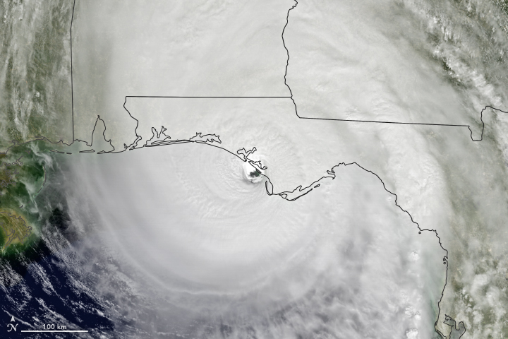
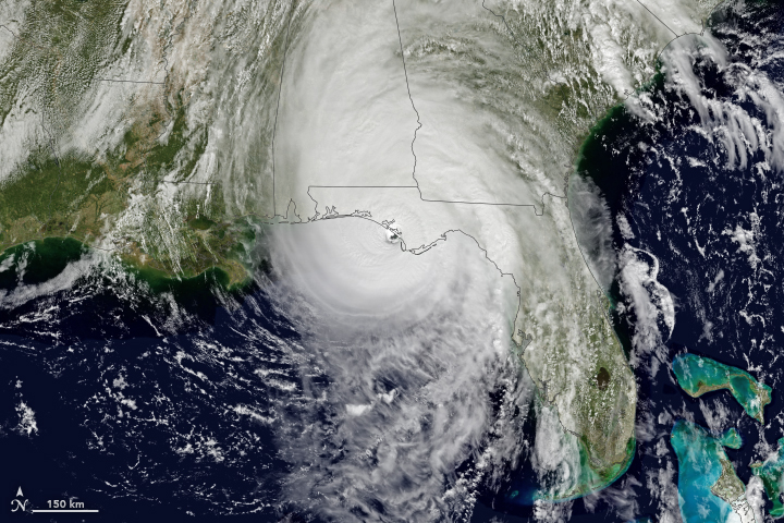
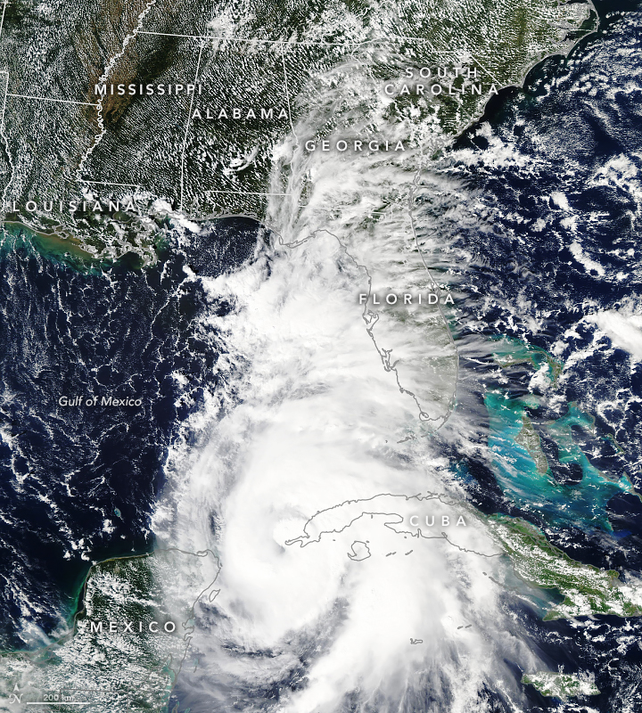
At approximately 1:30 p.m. Eastern Daylight Time (17:30 Universal Time) on October 10, 2018, Hurricane Michael made landfall near Mexico Beach, Florida. Wind speeds were estimated to be 155 miles (250 kilometers) per hour, which would make the category 4 hurricane the strongest on record to hit the Florida Panhandle. The storm has already destroyed homes and knocked out electric power in the area. Forecasters expect Michael to bring heavy winds and rain to the southeastern United States for several days.
The Geostationary Operational Environmental Satellite 16 (GOES-16) acquired data for the composite images above around 1 p.m. Eastern Time on October 10. GOES-16 data (band 2) were overlaid on a MODIS “blue marble.” GOES-16 is operated by the National Oceanic and Atmospheric Administration (NOAA); NASA helps develop and launch the GOES series of satellites.
The National Weather Service office in Tallahassee issued an extreme wind warning as the storm approached. Forecasters were expecting large storm surges—rising seawater that moves inland as it is pushed onshore by hurricane-force winds. The worst surges were expected to inundate areas between Tyndall Air Force Base and Keaton Beach with 9 to 14 feet of water on October 10.
As the storm moves inland, forecasters expect life-threatening winds to also affect parts of Alabama and Georgia. Areas as far as southeastern Virginia could see several inches over the next three days. North Carolina has declared a state of emergency as the storm forecast has it passing over areas that were affected by Hurricane Florence last month.
NASA Earth Observatory images by Joshua Stevens, using data from GOES-16. Story by Kasha Patel.
Hurricane Michael Reaches North Carolina
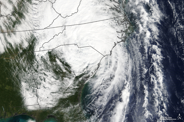
Friday, October 12th, 2018Since making landfall in Florida on October 10, 2018, Hurricane Michael has caused severe property damage and several deaths in Florida, Alabama, Georgia, South Carolina, and North Carolina. Forecasters expect the storm center will continue to track across North Carolina and Virginia, bringing the potential for life-threatening flash flooding. Michael should move into the western Atlantic Ocean by October 12.
The natural-color image above was taken on the morning of October 11, 2018, as the storm made its way into North Carolina. The image was acquired by the Moderate Resolution Imaging Spectroradiometer (MODIS) on NASA’s Terra satellite.
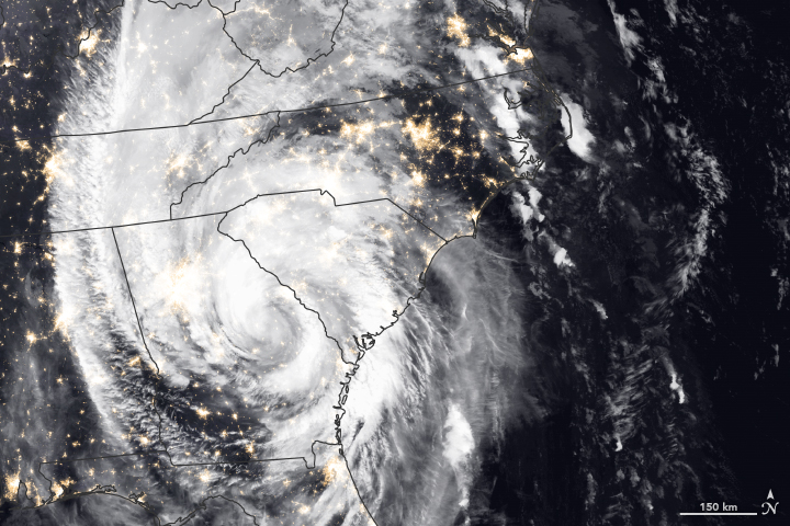
The category 4 hurricane weakened throughout October 10 and was downgraded to a tropical storm by October 11. The Visible Infrared Imaging Radiometer Suite (VIIRS) on the Suomi NPP satellite acquired data for the composite image below in the early morning hours of October 11, as the storm passed over Georgia and South Carolina. The false-color image shows infrared signals known as brightness temperature, which helps distinguish the shape and temperature of the clouds. The image was overlaid on data from the VIIRS “day-night band.”
According to news reports, the storm knocked out power to hundreds of thousands of homes and radio towers, making communication difficult. Water levels in several rivers in North Carolina and Virginia rose by several feet in a matter of hours and are expected to enter moderate to major flooding stages. The National Weather Service also warned about the potential for tornadoes in North Carolina and Virginia.
NASA Earth Observatory image by Joshua Stevens, using MODIS data from NASA EOSDIS/LANCE and GIBS/Worldview and VIIRS data from the Suomi National Polar-orbiting Partnership. Story by Kasha Patel.
Hospitals in crisis after Michael
Friday, October 12th, 2018- “…Bay Medical Center, a 300-bed hospital…..The governor had announced that all of the patients in the hospital were to be evacuated, which was expected to take 48 hours.
- And other residents of the ravaged city were still showing up asking for medical care only to be turned away……
- Some hospitals in the region closed entirely, and others evacuated their patients, but kept staff in place to run overwhelmed emergency rooms.
- In Florida, four hospitals and 11 nursing facilities were closed….
- 35 hospitals or nursing homes in that state were without electricity and operating with generators……
- Federal health officials said they were moving approximately 400 medical and public health responders into affected areas, including six disaster teams that can set up medical operations outdoors. Some were heading to an overwhelmed emergency department in Tallahassee.
- Other federal medical personnel were being assigned to search-and-rescue teams to triage people who were rescued…
- There was a rush to move around 40 people — post-heart surgery patients, critically ill septic patients, respiratory failure patients on ventilators — to safer quarters on lower floors in the central part of the building.
- Staff members and nurses had to carry some patients down stairways, fearing that the elevators had become unsafe……
- Gulf Coast Regional Medical Center said on Thursday that it was evacuating all of its approximately 130 inpatients, starting with the most critically ill. The hospital, which was running on backup generator power, had sustained roof and window damage from the storm.……“
Michael: Six deaths have been confirmed – four in Florida, one in Georgia, and one in North Carolina.
Thursday, October 11th, 2018“…..In the town of Chattahoochee, the Florida State Hospital, which is the state’s largest and oldest psychiatric hospital, was inaccessible in the wake of Michael, according to the Miami Herald. The facility’s 975 residents and 325 staffers had ample supplies, especially after food and water drops via helicopter, but the hospital lost all communication with the outside world, the report added…..”
https://www.youtube.com/watch?v=hPJ6fhQ8-Tw
Images of Michael
Wednesday, October 10th, 2018https://www.youtube.com/watch?v=GOBXJCqmuw0
https://www.youtube.com/watch?v=HQYxVHIOH-A
10/10/1780: A powerful hurricane slams the islands of the West Indies, killing more than 20,000
Wednesday, October 10th, 2018Michael on Radar: Making landfall today
Wednesday, October 10th, 2018
- “Hurricane Michael has intensified to a Category 4 major hurricane in the Gulf of Mexico.
- Michael is expected to make landfall along Florida’s northeastern Gulf Coast Wednesday.
- A Category 4 or stronger hurricane has never made landfall in the Florida Panhandle.
- Michael has maximum sustained winds of 130 mph.
- Dangerous storm surge, damaging winds and flooding rain are likely impacts from the storm.
- Hurricane warnings and storm surge warnings have been issued along the Gulf Coast of Florida.
- Tropical storm warnings and watches are posted along the Southeast coast as far north as the Outer Banks.
- Heavy rain and strong winds will spread inland across parts of the Southeast after landfall.”
Heat in the Gulf fuels Michael: NOAA
Wednesday, October 10th, 2018In September, North Carolina took a direct hit from a hurricane. Now it is Florida’s turn.
What began as a tropical disturbance in the Caribbean Sea on October 2, 2018, went on to graze the Yucatan Peninsula and then strengthen into Hurricane Michael. The storm continued on its way through the Caribbean Sea and the Gulf of Mexico.
National Hurricane Center forecasters expect the storm to make landfall in the Florida Panhandle or Big Bend region around midday on October 10. This area has faced relatively few hurricanes in the past, at least for the U.S. state that sees more landfalling hurricanes than any other.
“Only eight major hurricanes on record have passed within or near the projected landfall of Michael, and only three of those (Eloise 1975, Opal 1995, and Dennis 2005) were in the past 100 years,” noted Marangelly Fuentes, a NASA atmospheric scientist who has been tracking the storm with models maintained by NASA’s Global Modeling and Assimilation Office (GMAO). “Michael’s projected intensity at landfall is currently category 3, which is worrisome because many people living in the Panhandle have little or no experience with storms this intense.”
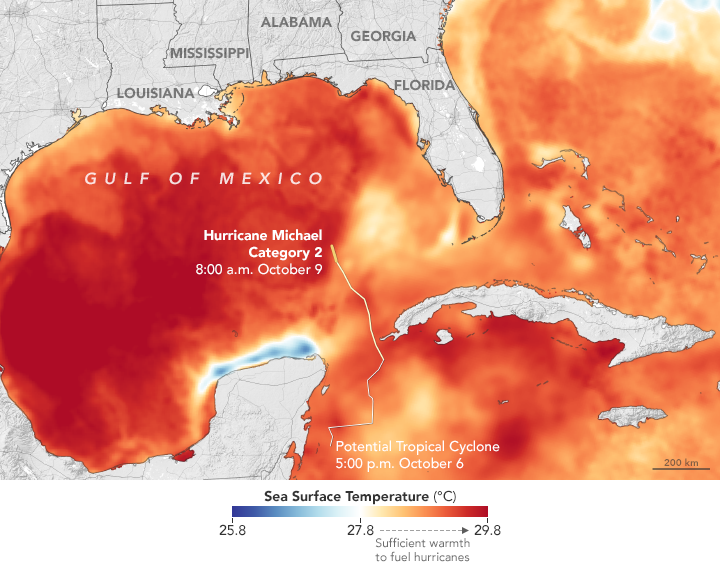
As Michael approaches land, two key factors will help govern the intensity of the storm: ocean temperatures and wind shear, the difference in wind speeds at upper and lower parts of a storm. Warm ocean water and low wind shear are required to sustain or intensify a hurricane’s strength.
Michael managed to strengthen despite facing significant westerly shear in the Caribbean Sea on October 9, something the National Hurricane Center called “most unusual.” It then passed into an area of low shear and warm ocean water on October 10, where it continued to intensify.
The map above shows sea surface temperatures on October 8-9, 2018. Meteorologists generally agree that sea surface temperatures (SSTs) should be above 27.8°C (82°F) to sustain and intensify hurricanes (although there are some exceptions). The data for the map were compiled by Coral Reef Watch, which blends observations from the Suomi NPP, MTSAT, Meteosat, and GOES satellites and computer models. Information about the storm track and winds come from the National Hurricane Center.
Unlike Hurricane Florence, which made landfall September 14 in North Carolina as a slow-moving category 1 storm, there are no indications that Michael will stall near the coastline. “The storm is fast moving, so only 6-10+ inches (15-25+ centimeters) of precipitation are forecasted to fall over the Panhandle,” said Fuentes.
However, forecasters do expect the storm to bring life-threatening winds and storm surge. On October 7, the governor of Florida declared a state of emergency and urged people in the path of the storm to evacuate.
The Moderate Resolution Imaging Spectroradiometer (MODIS) on NASA’s Aqua satellite acquired this natural-color image of Hurricane Michael on the afternoon of October 8, 2018.
NASA Earth Observatory images by Joshua Stevens and Lauren Dauphin, and sea surface temperature data from Coral Reef Watch, storm track information from Weather Underground and MODIS data from NASA EOSDIS/LANCE and GIBS/Worldview. Story by Adam Voiland.
Nat’l Hurricane Center 4AM CDT, 10/10/18 Advisory: Michael Cat. 4
Wednesday, October 10th, 2018Hurricane Michael Advisory Number 15
NWS National Hurricane Center Miami FL AL142018
400 AM CDT Wed Oct 10 2018
…EXTREMELY DANGEROUS CATEGORY 4 MICHAEL STRENGTHENS
FURTHER AS IT HEADS NORTHWARD TOWARD THE FLORIDA PANHANDLE…
…LIFE-THREATENING STORM SURGE…HURRICANE FORCE WINDS…AND HEAVY
RAINFALL EXPECTED ALONG THE NORTHEASTERN GULF COAST…
SUMMARY OF 400 AM CDT…0900 UTC…INFORMATION
———————————————-
LOCATION…28.3N 86.5W
ABOUT 140 MI…225 KM SSW OF PANAMA CITY FLORIDA
ABOUT 130 MI…215 KM SW OF APALACHICOLA FLORIDA
MAXIMUM SUSTAINED WINDS…140 MPH…220 KM/H
PRESENT MOVEMENT…N OR 360 DEGREES AT 13 MPH…20 KM/H
MINIMUM CENTRAL PRESSURE…943 MB…27.85 INCHES
WATCHES AND WARNINGS
——————–
CHANGES WITH THIS ADVISORY:
A Tropical Storm Warning is now in effect from South Santee River,
South Carolina to Surf City, North Carolina.
The Storm Surge Watch has been discontinued west of the
Okaloosa/Walton County Line Florida.
SUMMARY OF WATCHES AND WARNINGS IN EFFECT:
A Storm Surge Warning is in effect for…
* Okaloosa/Walton County Line Florida to Anclote River Florida
A Storm Surge Watch is in effect for…
* Anclote River Florida to Anna Maria Island Florida, including
Tampa Bay
A Hurricane Warning is in effect for…
* Alabama/Florida border to Suwannee River Florida
A Tropical Storm Warning is in effect for…
* Alabama/Florida border to the Mississippi/Alabama border
* Suwanee River Florida to Chassahowitzka Florida
* North of Fernandina Beach Florida to Surf City North Carolina
A Tropical Storm Watch is in effect for…
* Chassahowitzka to Anna Maria Island Florida, including Tampa Bay
* Mississippi/Alabama border to the Mouth of the Pearl River
* Surf City North Carolina to Duck North Carolina
* Pamlico and Albemarle Sounds
A Storm Surge Warning means there is a danger of life-threatening
inundation, from rising water moving inland from the coastline,
during the next 36 hours in the indicated locations. For a depiction
of areas at risk, please see the National Weather Service Storm
Surge Watch/Warning Graphic, available at hurricanes.gov. This is
a life-threatening situation. Persons located within these areas
should take all necessary actions to protect life and property from
rising water and the potential for other dangerous conditions.
Promptly follow evacuation and other instructions from local
officials.
A Hurricane Warning means that hurricane conditions are expected
somewhere within the warning area, in this case within the next
12 hours. Preparations to protect life and property should be
rushed to completion.
A Tropical Storm Warning means that tropical storm conditions are
expected somewhere within the warning area, in this case during the
next 12 hours.
A Storm Surge Watch means there is a possibility of life-
threatening inundation, from rising water moving inland from the
coastline.
A Tropical Storm Watch means that tropical storm conditions are
possible within the watch area.
Interests elsewhere across the southeastern United States should
monitor the progress of Michael.
For storm information specific to your area, including possible
inland watches and warnings, please monitor products issued by your
local National Weather Service forecast office.
DISCUSSION AND OUTLOOK
———————-
At 400 AM CDT (0900 UTC), the eye of Hurricane Michael was located
near latitude 28.3 North, longitude 86.5 West. Michael is moving
toward the north near 13 mph (20 km/h). A turn toward the north-
northeast is expected this morning, with a turn toward the northeast
expected this afternoon or tonight. A motion toward the northeast at
a faster forward speed is forecast on Thursday and Friday. On the
forecast track, the eye of Michael is expected to move ashore over
the Florida Panhandle later today, move northeastward across the
southeastern United States tonight and Thursday, and then move off
the Mid-Atlantic coast away from the United States on Friday.
Reports from an Air Force Reserve Hurricane Hunter aircraft indicate
that maximum sustained winds have increased to near 140 mph (220
km/h) with higher gusts. Michael is an extremely dangerous category
4 hurricane on the Saffir-Simpson Hurricane Wind Scale. Some
additional strengthening is possible before landfall. After
landfall, Michael should weaken as it crosses the southeastern
United States.
Hurricane-force winds extend outward up to 45 miles (75 km) from the
center and tropical-storm-force winds extend outward up to 185 miles
(295 km). NOAA buoy 42039 to the northeast of the center recently
reported sustained winds of 54 mph (85 km/h) and a wind gust of
63 mph (101 km/h).
The estimated minimum central pressure based on Hurricane Hunter
aircraft data is 943 mb (27.85 inches).
HAZARDS AFFECTING LAND
———————-
STORM SURGE: The combination of a dangerous storm surge and the
tide will cause normally dry areas near the coast to be flooded by
rising waters moving inland from the shoreline. The water has the
potential to reach the following heights above ground if peak surge
occurs at the time of high tide…
Tyndall Air Force Base FL to Keaton Beach FL…9-13 ft
Okaloosa/Walton County Line FL to Tyndall Air Force Base FL…6-9 ft
Keaton Beach FL to Cedar Key FL…6-9 ft
Cedar Key FL to Chassahowitzka FL…4-6 ft
Chassahowitzka to Anna Maria Island FL including Tampa Bay…2-4 ft
WIND: Hurricane conditions are expected within the hurricane
warning area along the U.S. Gulf Coast today, with tropical storm
conditions expected to begin during the next few hours. Hurricane
conditions will also spread well inland across portions of the
Florida Panhandle, southeastern Alabama and southwestern Georgia.
Tropical storm conditions are expected in the tropical storm warning
area during the next several hours, and are possible within the
tropical storm watch area by that time. Hurricane conditions are
possible within the hurricane watch area today.
Tropical storm conditions are expected to spread northward within
the warning area along the southeast U.S. coast beginning tonight,
and are possible in the watch area by late Thursday and Thursday
night.
RAINFALL: Michael is expected to produce the following rainfall
amounts through Friday…
Florida Panhandle and Big Bend, southeast Alabama, and portions of
southwest and central Georgia…4 to 8 inches, with isolated maximum
amounts of 12 inches. This rainfall could lead to life-threatening
flash floods.
The remainder of Georgia, the Carolinas, and southern Virginia…3
to 6 inches, with isolated maximum amounts of 8 inches. This
rainfall could lead to life-threatening flash floods.
Florida Peninsula, eastern Mid Atlantic, southern New England
coast…1-3 inches.
SURF: Swells generated by Michael are affecting the coasts of the
eastern and northern Gulf of Mexico, and will spread to portions of
the northwestern and western Gulf of Mexico coast during the next
day or so. These swells are likely to cause life-threatening surf
and rip current conditions. Please consult products from your local
weather office.
TORNADOES: A few tornadoes will be possible across parts of the
Florida Panhandle and the northern Florida Peninsula through this
afternoon. This risk will spread into parts of central and southern
Georgia and southern South Carolina this afternoon and tonight.
NEXT ADVISORY
————-
Hourly position estimates will begin at 500 AM CDT.
Next intermediate advisory at 700 AM CDT.
Next complete advisory at 1000 AM CDT.
$$
Forecaster Beven


