Archive for the ‘Tropical storms’ Category
Situation Post-Tropical Cyclone Dorian is heading towards Newfoundland, Canada and is no longer impacting the U.S.
Sunday, September 8th, 2019Lifeline All lifelines are Green
Safety and Security
• US&R: all task forces and Red IST have demobilized and are returning to home station (NRCC SLB 1:00 p.m. EDT) • NC Evacuations: • Mandatory for Dare County • Hyde County under ferry restrictions, only first responder personnel allowed to and from the island (Region IV as of 3:25 am EDT)
Food, Water, Shelter
• NC Shelters: 1 shelter open with 1 occupant (Region IV as of 7:30 a.m. EDT)
Energy
• Minimal power outages remain across impacted states (As of 7:30 am EDT. Customer outage data is provided by the Department of Energy’s EAGLE-I system. Comprehensive National coverage of all electrical service providers is not available.)
Transportation
• NC Ports: Wilmington open with restrictions; Morehead City closed, anticipate re-opening on Sep 9 (NRCC SLB as of 1:00 p.m.)
State/Local Response
• SC Governor requested a Major Disaster Declaration on Sep 5 • GA EOC at Full Activation • NC EOC at Partial Activation • TN, VA and MD EOCs at Monitoring • SC and MS EOCs returned to Normal Operations
Federal Response
• NRCC de-activated • Region III RWC returned to Steady State; RRCC de-activated o LNOs remain deployed • Region IV RRCC de-activated o LNOs deployed to SC, NC, FL and GA • IMAT Teams deployed: o Region III IMAT: demobilized and returned to home station o Region IV IMAT-1: demobilizing; IMAT-2: returned to home station o Region VII IMAT: SC; will demobilize on Sep 9 o Region VIII IMAT: NC • ISB Teams deployed to AL, GA, NC, and SC o Charlie Team at Fort A.P. Hill, VA • MERS assets deployed to NC, SC, VA, FL and GA
September 8, 1900: “……One of the deadliest hurricanes in U.S. history hits Galveston, Texas….killing more than 6,000 people……”
Sunday, September 8th, 2019FEMA SitRep, 9/7/19: Dorian’s impact
Sunday, September 8th, 2019Lifeline NC Energy lifeline is YELLOW; anticipate returning to GREEN later today as power is restored; all other lifelines remain Green

Safety and Security • US&R: Fort Bragg, NC: 1 Type I TF, 7 Type III TFs, 3 MRP-W TFs, and 1 HEPP; Ft. Jackson, SC: 1 Type 1 TF, 1 Type III TF; 1 MRP-W TF, 1 HEPP package; Columbia, SC: 1 Red IST (has begun demobilizing), 1 IST C cache, 1 IST E cache (ESF-9 Update, NRCC SLB 12:00 p.m. EDT) • Evacuations: NC –Mandatory 3 counties, voluntary 8 counties; SC evacuations lifted
Food, Water, Shelter • Shelters: NC 12 (-63) with 901 (-2,888) occupants; SC 1 (-22) with 16 (-1,339)occupants; VA 1 with 76 occupants (ARC Midnight Shelter Count as of 6:16 a.m. EDT) • Planned capacity for sheltering across SC, NC and VA is 30k Health and Medical • Fatalities / Injuries: FL 6 / 0; NC 1 / 0 (NRCC SLB as of 6:00 p.m. EDT)
Energy • SC: 30k (peak 160k) customers without power; NC: 61k (peak 235k) customers (DOE Eagle- I as of 6:45 a.m. EDT) • All cities reporting at least 90% retail fuel availability (NRCC SLB as of 6:00 a.m. EDT)
Transportation • Airports: NC and SC – all airports open • Ports: NC: Wilmington open with restrictions (NRCC SLB as of 6:00 p.m.)
Local Preparations/Response • SC Governor requested a Major Disaster Declaration on Sep 5 • NC EOC at Full Activation • VA and MD EOCs at Partial Activation • TN, MS and SC EOCs at Monitoring
Federal Preparations/Response • NRCC at Level I, day shift; Level III with select ESFs, night shift • Region III RWC at Enhanced Watch, night shift; RRCC transitioned to Level III, day shift only o LNO deployed to VA and MD • Region IV RRCC at Level I, 24/7 o LNOs deployed to SC and NC • IMAT Teams deployed: o Region III IMAT: VA EOC o Region IV IMAT-1: FL; IMAT-2: reconstituting o Region VII IMAT: SC o Region VIII IMAT: NC • ISB Teams deployed to AL, GA, NC, and SC o Charlie Team at Fort A.P. Hill, VA • MERS assets deployed to NC, SC, VA, FL and GA


Typhoon Lingling
Saturday, September 7th, 2019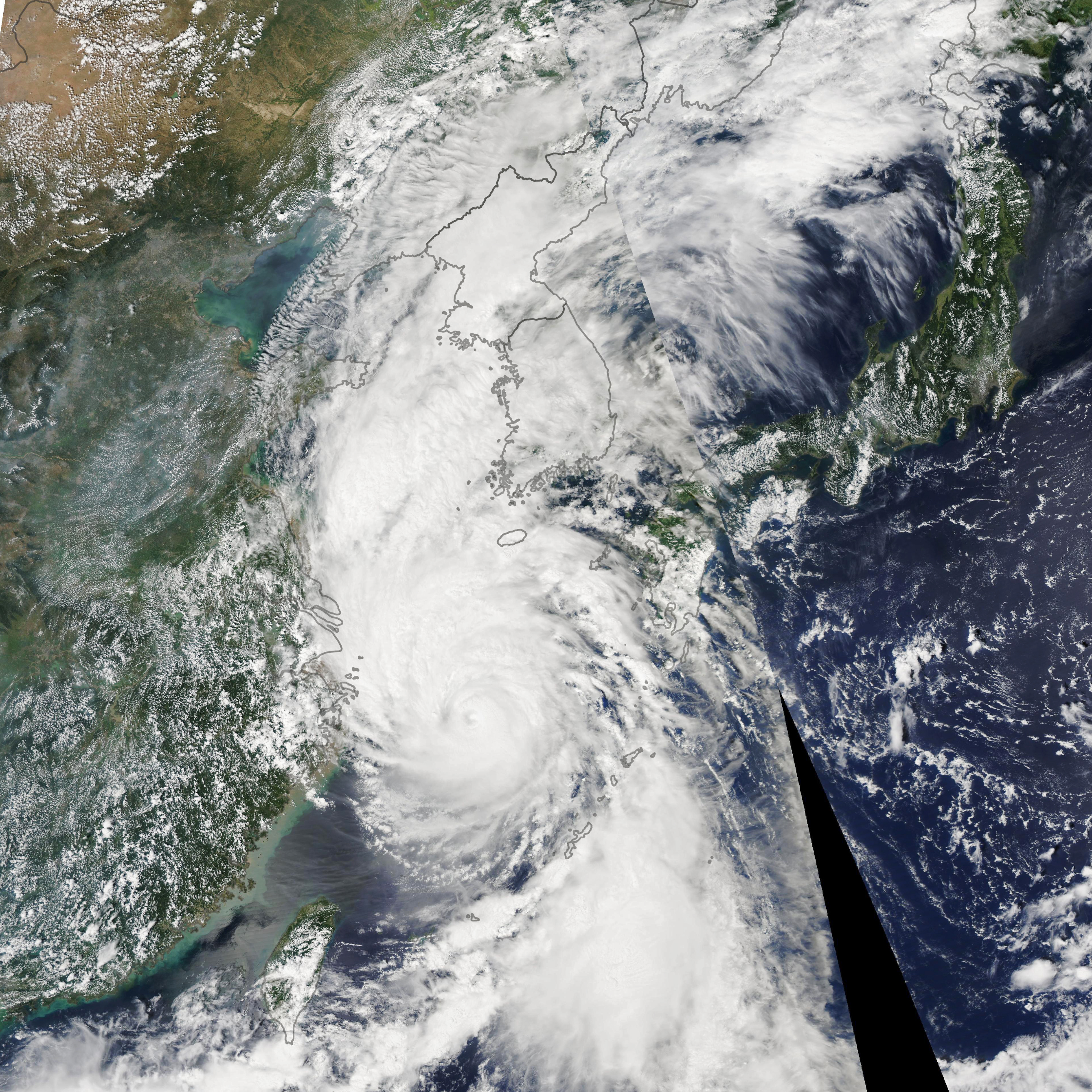
“…….With maximum sustained winds of around 160 kilometers (95 miles) per hour, the typhoon is now headed toward South and North Korea.
The Moderate Resolution Imaging Spectroradiometer (MODIS) on NASA’s Aqua satellite acquired this image of the typhoon on September 6, 2019. The storm was moving north at 40 kilometers (25 miles) per hour and is expected to reach the Yellow Sea on September 7. It is then forecasted to make landfall in North Korea, according to the Japan Meteorological Agency.
The typhoon is expected to weaken as its outer bands interact with land on South Korea, but forecasters still expect torrential rainfall and damaging winds. Forecasters predict around 75 to 150 millimeters (3 to 6 inches) of rainfall and a storm surge, both of which may cause flooding and landslides.
Typhoon Lingling is the thirteenth tropical cyclone (typhoon or tropical storm) in the North Pacific this year. However, the Korean Peninsula typically sees just one landfalling storm per year…..”
NASA Earth Observatory image by Lauren Dauphin, using MODIS data from NASA EOSDIS/LANCE and GIBS/Worldview. Story by Kasha Patel.
NASA: Dorian skirts the eastern shoreline
Friday, September 6th, 2019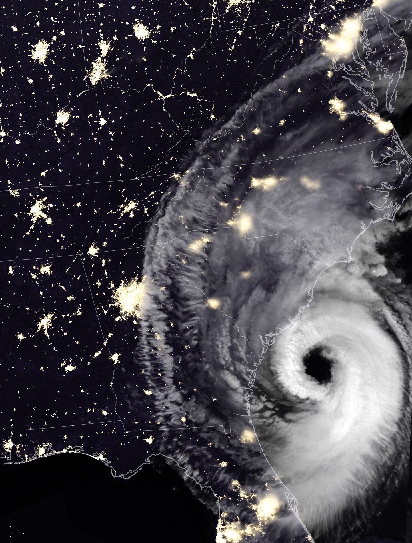
After devastating the Bahamas and grazing Florida and Georgia, Hurricane Dorian rebounded and raked the coast of South Carolina with strong winds, heavy rains, and a storm surge. Wind, falling trees, and flooding damaged power infrastructure in coastal areas of the southeast U.S.
The Visible Infrared Imaging Radiometer Suite (VIIRS) on the Suomi NPP satellite captured this nighttime composite image as the storm approached the coast at 3:42 a.m. Eastern Time (07:42 UTC) on September 5, 2019. At the time, Dorian packed maximum sustained winds of 115 miles (185 kilometers) per hour and was moving north at 8 miles per hour.
The VIIRS sensor observed thick cloud bands circulating around Dorian’s large eye, the part of the storm with mostly calm weather and the lowest atmospheric pressure. Hurricane eyes average about 20 miles (32 kilometers); the National Hurricane Center reported Dorian’s eye had a diameter of 50 miles (80 kilometers) around the time this image was acquired. Thinner clouds—part of the storm’s higher-level outflow—extended well inland across Georgia, South Carolina, and North Carolina.
The VIIRS image was captured by the sensor’s day-night band, which detects light in a range of wavelengths from green to near-infrared and uses filtering techniques to observe signals such as gas flares, city lights, and reflected moonlight. Infrared observations from VIIRS were used to enhance the visibility of clouds. Optical MODIS satellite data was layered into the image to make it easier to distinguish between ocean and land surfaces.

It is not possible to identify the locations of power outages based on the VIIRS night light image alone. However, as of 2 p.m. on September 5, several utility companies and Poweroutages.us were reporting more than 240,000 outages in South Carolina. The hardest hit area was Charleston County, where companies were reporting more than 130,000 outages.
In the coming days, forecasters expect Dorian to move near or over the coast of North Carolina and then toward New England and Nova Scotia.
NASA Earth Observatory images by Joshua Stevens, using VIIRS data from the Suomi National Polar-orbiting Partnership, and power outage data courtesy of PowerOutage.us. Story by Adam Voiland.